Wantsum Channel — The Wantsum Channel is the name given to a now silted up watercourse separating the Isle of Thanet and what was the mainland of the English county of Kent. The river Wantsum is now little more than a drainage ditch lying between Reculver and the… … Wikipedia
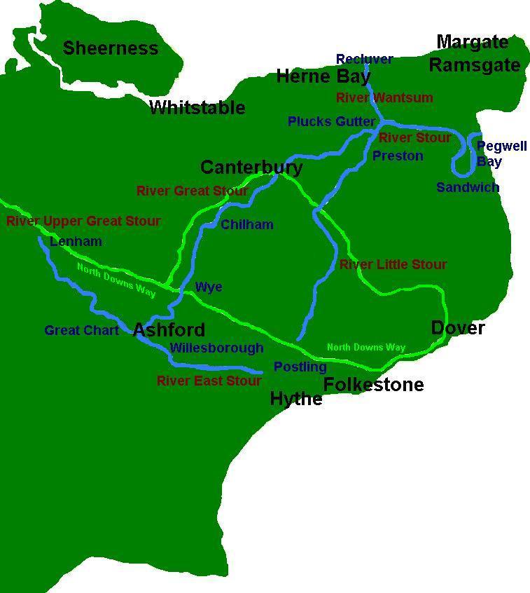
River Stour, Kent — Infobox River river name = River Stour image size = caption = River Stour and Tributaries origin = Postling and Lenham mouth = Pegwell Bay basin countries = length = elevation = mouth elevation = discharge = watershed = The River Stour… … Wikipedia
River Great Stour — Infobox River river name = River Great Stour image size = caption = River Stour and Tributaries origin = Ashford TR 01539 42793 Coord|51.14890|0.88020|display=inline|format=dms mouth = River Stour TR 26943 63444… … Wikipedia
River Great Stour — Río Great Stour (River Great Stour) Mapa del River Stour y sus afluentes. País que atraviesa … Wikipedia Español
River Stour (Kent) — Flusssystem des River Stour im Osten Kents Eine der vielen Wassermühlen entlang d … Deutsch Wikipedia
Isle of Thanet — The Isle of Thanet lies at the most easterly point of Kent, England. Archaeological remains testify to the fact that ancient peoples lived here. Its position close to Continental Europe meant that it was an ideal invasion place. Today it is a… … Wikipedia
Rivers of Kent — There are four rivers draining the county of Kent, England. River Medway This is the main river, whose catchment area covers almost 25% of the county. The detailed map has a diagram of that catchment area, which includes its main tributaries: the … Wikipedia
Sarre Penn — is a tributary of the River Stour in Kent, England, joining with the River Wantsum near Sarre, where it is known locally as the Fishbourne Stream . [ [http://www.kent.gov.uk/NR/rdonlyres/C076B52E 9D6A 4CD5 B135 F3EC29F3FEF3/1112/crabandwinkle.pdf … Wikipedia
Grazing marsh — is the term used in the British Isles for flat, marshy grassland in polders. It consists of large grass fields separated by fresh or brackish ditches, and is often important for its wildlife.HistoryGrazing marsh was created from Medieval times by … Wikipedia
St. Nicholas-at-Wade — infobox UK place country = England official name= St. Nicholas at Wade static static image caption=The Street, St. Nicholas at Wade population = 782 (Civil Parish)2001 Census: Key Statistics, Parish Profile, St. Nicholas at Wade CP] shire… … Wikipedia