Mill River (Connecticut)

Mill River (Connecticut)
Not to be confused with the Mill River (Fairfield, Connecticut) or the Rippowam River in Stamford, Connecticut
Mill River, Hamden, Connecticut. Sleeping Giant Mountain in background. Photo by Geoff Fox.
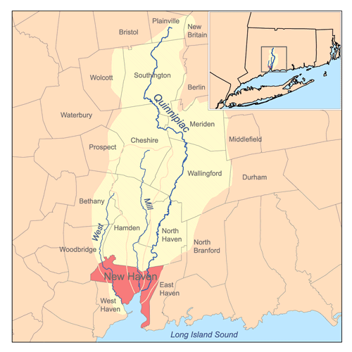
Map showing the Mill River and other rivers draining to New Haven Harbor, with their combined watersheds.

The Mill River is a river in the U.S. state of Connecticut.[1]

The river starts in the town of Cheshire, flows through Hamden and New Haven, and discharges into New Haven Harbor on Long Island Sound. The river's length is 17.4 miles (28.0 km).[2] The river is dammed in southern Hamden to form Lake Whitney, which is operated as a reservoir by the South Central Connecticut Regional Water Authority.

A mill for grinding corn was built on a Quinnipiack ford near East Rock in 1642. By 1780 there were eight mills. In time the river provided power for Eli Whitney's gun factory, now the Eli Whitney Museum.

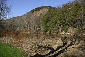
Mill River passes through Sleeping Giant State Park in northern Hamden and East Rock Park below Lake Whitney in Hamden. These are among the river's reaches that remain undeveloped and are popular spots for fishing and hiking.

English Station, an abandoned power plant, lies on Ball Island in the New Haven terminus of the river.

References

  1. ^ Mill River Basin: 01196620 Mill River near Hamden, page 168 in U.S. Geological Survey Water Resources Data, Connecticut, Water Year 2005
  2. ^ U.S. Geological Survey. National Hydrography Dataset high-resolution flowline data. The National Map, accessed April 1, 2011

Further reading

  • 1998. The Streets of New Haven - The Origin of Their Names, (2nd ed.) ISBN 0-943143-02-0

Coordinates: 41°25′15″N 72°54′12″W / 41.42083°N 72.90333°W / 41.42083; -72.90333


Wikimedia Foundation. 2010.

Игры ⚽ Нужен реферат?

Look at other dictionaries:

  • Mill River — may refer to: Streams in Canada Mill River (Prince Edward Island) in the United States Mill River (Connecticut), a river in Cheshire, Hamden, and New Haven, Connecticut Mill River (Fairfield, Connecticut), a river in the town of Fairfield,… …   Wikipedia

  • Mill River Historic District — U.S. National Register of Historic Places U.S. Historic district …   Wikipedia

  • Mill River (Springfield, Massachusetts) — The Mill River is a 1.25 mile (2.01 km) long tributary of the Connecticut River in Springfield, Massachusetts. It flows from Watershops Pond (also known as Lake Massasoit) to its confluence with the Connecticut River. It is referred to as… …   Wikipedia

  • Mill River (neighborhood) — Coordinates: 41°18′25″N 72°54′36″W / 41.307°N 72.910°W / 41.307; 72.910 Mill River is a primarily industrial …   Wikipedia

  • Mill River (Fairfield, Connecticut) — The Mill River is a 16.3 mile (26.2 km) river in the town of Fairfield, Connecticut. It flows into Long Island Sound at Southport harbor.[1] Dams on the Mill River form the Easton, Hemlock, and Samp Mortar Lake Reservoirs and control… …   Wikipedia

  • Mill-River-Talsperre — Die Mill River Talsperre (Mill River Dam, Williamsburg Dam) in den Williamsburg Hills bei Williamsburg in Massachusetts, USA, versagte am 16. Mai 1874. Der gestaute Fluss war der Mill River (Mill Creek), ein Zufluss des Connecticut River. In dem… …   Deutsch Wikipedia

  • Mill River (Northampton, Massachusetts) — The Mill River is a 13.5 mile long (21.7 km)[1] tributary of the Connecticut River arising in the western hilltowns of Hampshire County, Massachusetts. It is notable for dropping in elevation, along with its West Branch, more than 700 feet… …   Wikipedia

  • Mill River (Hampshire County, Massachusetts) — The Mill River is a tributary of the Connecticut River arising in the Berkshires in Hampshire County, Massachusetts. It is notable for dropping in elevation more than 700 feet over 15 miles. History Dozens of mills were built along the Mill River …   Wikipedia

  • Connecticut River — Einzugsgebiet des Flusses Daten …   Deutsch Wikipedia

  • Connecticut River Greenway State Park — consists of a number of separate state land holdings in the Pioneer Valley of western Massachusetts. The park includes critical wildlife and plant habitat as well as areas providing public access to the Connecticut River. The Department of… …   Wikipedia

Share the article and excerpts

Direct link
Do a right-click on the link above
and select “Copy Link”