- Don Carlos, Bukidnon
-
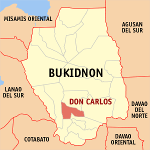
Municipality of Don Carlos Map of Bukidnon showing the location of Don Carlos, Bukidnon
Country Philippines Region Region X Province Bukidnon Districts 3rd District Barangays 29 Incorporated (town) June 18, 1966 Government - Mayor Felix S. Manzano - Vice Mayor Jude D. Palmada Area - Total 157.02 km2 (60.63 sq mi) Elevation 500 m (1 640.42 ft) Population (2000) - Total 55,495 - Density 354/km2 (915/sq mi) Time zone PST (UTC+8) ZIP code 8712 Area code(s) 88 Don Carlos is a 1st class municipality in the province of Bukidnon, Philippines. According to the 2000 census, it has a population of 55,495 people in 10,713 households.
Contents
History
The first person of this place before was Datu Andarol and Ba-e Mahanu are the parents of Datu ‘Mangginayun’.Datu Andarol was a ruler and a great leader of the manobo tribe in his place Minduso(Don Carlos). This place are very forest before and no one can tresspass his juristdiction without his permission. They got children in their time of living. They are Born, Die and burried in this place. When the time of Datu Manginayun Sr was come, every one needs to have a name. So he got the name Datu ‘Manginayun’ Antonio Sagandilan Sr. He was got married to Ba-e Antonina Manlayuan. Datu ‘Manginayun’ Antonio Sagandilan Sr was also a great leader like his father. He implement the law and settle the problems like murder case. He also lead the wedding ceremonies, doraise and the tribal community. The first popular spanish stranger that come to our grandfather is Thomas Sandoval. He ask for a parsel of land that he want to borrow,he want to make it a ricefield and Datu ‘Manginayun’ Antonio Sagandilan Sr give him. He offer an agreement that every croppings he will give in return, even any product. As the time goes by, there is new spanish that come and again ask Datu ‘Manginayun’ Antonio Sagandilan Sr to borrow a land to make a ranches, he is Elizalde.
Pantel-pantilan, Migtutugop, Mulita river Squash mountain and Tugas falls, are area borrowed by Elizalde before and all this native name has a meaning for them and only the “Manobo” can translate it to other language,especially the elders.
Before, the Don Carlos place was not have a name yet. Only the Ramag (Breakfast) known now as the municipality of Maramag. Datu Manginayun Antonio Sagandilan jr the son of Datu ‘Manginayun’ Antonio Sagandilan Sr was born on March 17,1917 at “Miuvan”(Sinangguyan), his parent register him at Maramag because only this place is already civilized on their time. When World WarII was started in the Philippines. Datu Manginayun Antonio Sagandilan jr was hired as USAFE army,his wife and parents was nothing to do about his decision. He was also a Corporal before. Later on, when the World WarII was ended, Datu ‘Manginayun’ Antonio Sagandilan Sr was died and buried in this place. Not of the war but because of old age.
Datu Manginayun Antonio Sagandilan jr inherited the leadership of his tribe as a Datu . He became counselor before on his tribe, they called it now a barangay captain. In his time of service, Senyora Meding Fortich personally visit Datu Manginayun Antonio Sagandilan jr . She want him to change the name of “Miuvan”(Sinangguyan) to Don Carlos as a remembrance of his living in the land of Sagandilan. But Datu Manginayun Antonio Sagandilan jr did not allow her to change the entire place because this place is very memorable and valuable to him. He only allow her just the place beyond “miuvan” the place “Bot-bot”, this place don’t have permanent name. sometimes they called it “minduso”. Senyora Meding was so happy and so thankful for the permission of Datu Manginayun Antonio Sagandilan jr. Meanwhile Senyora Meding Fortich was held the celebration and innaguration in a ritual way as an official baptism of the place named Don Carlos. The sacred place of the Sagandilan ancestor before is the Pinamaloy Lake. Even before the migrant came, the pinamaloy lake is already their sacred and ritual place that down to Datu Manginayun Antonio Sagandilan jr inherited until now. This place is located at Menduso(Don Carlos). They even know until now the name of each river in this place and they also know the boundaries of the land properties owned by their ancestor. they also know where is the salted water spring that their grandparents cooked and became stone salt. They don’t even need to go to kagay-an to buy a sack of salt before. they also know the area where you can make a kettle because of its clay soil.The grandchildren of Sagandilan inherit not only the land but also the costumes and tradition of their tribe. This place was very memorable for the Sagandilan even though they do not owned it now because of the migrant that owned this place.
Geography
Location
Don Carlos is situated in the southern part of the province. It is located 61 km south of the City of Malaybalay, 161 km from Cagayan de Oro City, 180 km from the City of Cotabato, 160 km from Davao and 1,575 km from south of Manila. The town is bounded by the municipalities of Maramag in the north, Kitaotao in the south, Quezon in the east, Pangantucan and Kadingilan in the west. The town is known for its famous landmark — Lake Pinamaloy.
Soil Type
There are 3 types of soil that cover the municipality. Theses soils, which are generally clayey, are Kidapawan Clay, Adtuyon Clay and Macolod Clay.
Topography
The terrain of the municipality of Don Carlos is generally flat except the mountain range on the eastern part of the municipality. The highest elevation is 700 meters above sea level and 300 meters below sea level.
Slope
Flat to gently sloping areas ranging in slope 0-8% is the most prevalent terrain in the municipality, which covers 198.96 km² (93.09%) of the total land area of the municipality. Moderately sloping to undulating lands ranging in slope 8-18% occupies approximately 7.65 km². Rolling to moderately steep lands, 18-30% covers 4.19 km² of land. An area with slope above 30% covers 2920.09 km².
Climate
The municipality's climate falls under the third type. Climate under this type experience rainy season in the months of April to September. The latest data from the DA shows that the months July to November registered the highest average annual rainfall that reached its peak in the month of July at 642 mm.
Economy
Commerce & Trade
Commercial activities in the municipality of Don Carlos pass through a network of various commercial establishments that scatter all over the municipality. Sari-sari stores dominate these establishments with heavy concentration in barangay centers, especially in barangay Don Carlos Sur.
Based on CY 2000 records of the Municipal Treasurer's Office (MTO), the municipality of Don Carlos had a total of 350 commercial establishments, majority of these commercial establishments are engaged in retailing, merchandising, food and beverage, catering and servicing.
Agriculture
Don Carlos is an agricultural municipality. It is endowed with vast tracks of fertile agricultural lands coupled with a favorable climate. Many people in the area are greatly dependent on the produce of the land. Being the main source of income of the municipality, agriculture utilizes about 149.5894 km² of land, representing 70% of the total land area of the municipality for the production of various crops.
In terms of production, in the year 1998, rice yielded 3,156.60 metric tons both in irrigated and rainfed farms. White and yellow corn production accounted to 39,086.10 metric tons covering 66.98 km² representing 11.78% to agricultural area. sugarcane production as second major crop next to corn, covers a physical area of 50 km² representing 33.42% with a total production of 21,000 metric tons.
The cash crops include leafy green vegetables, fruits, legumes and root crops.Coconut, sugarcane, banana, jackfruit, cacao and rubber comprise the commercial crops. Commercial crops cover 24.4194 km² and has a total production 2,523.75 metric tons.
Tourism
The Municipality of Don Carlos is naturally endowed with scenic vistas that have strong potentials as tourist attractions. These are the undeveloped Lake Pinamaloy in Barangay Pinamaloy; the Sinangguyan and Kahulugan Waterfalls in Barangay Sinangguyan; and the amazing Linking Caves and Spring in Barangay San Antonio East.
Lake Pinamaloy Lake Pinamaloy has an approximate area of 0.6 km². It is considered as landmark and a tourist attraction, thus a development plan has been prepared and was submitted to the Department of Tourism as a blueprint of the program.
Sinangguyan and Kahulugan Falls Combined to the scenic spot of the municipality is the Sinangguyan and Kahulugan falls, which both have the approximate height of 20 to 25 meters.
Linking Caves and Spring Located in San Antonio East, the amazing Linking Caves and the Spring added beauty and wonder to the place. Reason enough that a proposal has been made to develop its nature into a swimming pool.
Evidently, these tourist sites are enriched with their innate physical features. Efforts would be done to exploit these potentials to extensive promotions in order to draw investors and encourage development.
Barangays
Don Carlos is politically subdivided into 29 barangays.
- Calao Calao
- Cabadiangan
- Bocboc
- Buyot
- Don Carlos Norte
- Embayao
- Kalubihon
- Kasigkot
- Kawilihan
- Kiara
- Kibatang
- Mahayahay
- Manlamonay
- Maraymaray
- Mauswagon
- Minsilagan
- New Nongnongan (Masimag)
- New Visayas
- Old Nongnongan
- Pinamaloy
- Don Carlos Sur (Pob.)
- Pualas
- San Antonio East
- San Antonio West
- San Francisco
- San Nicolas (Banban)
- San Roque
- Sinangguyan
- Bismartz
External links
Municipalities Baungon • Cabanglasan • Damulog • Dangcagan • Don Carlos • Impasug-ong • Kadingilan • Kalilangan • Kibawe • Kitaotao • Lantapan • Libona • Malitbog • Manolo Fortich • Maramag • Pangantucan • Quezon • San Fernando • Sumilao • TalakagComponent cities Malaybalay • ValenciaCategories:- Municipalities of Bukidnon
Wikimedia Foundation. 2010.