- Manukan, Zamboanga del Norte
-
Municipality of Manukan
Bayan ng Manukan— Municipality — Municipality of Manukan 
SealMap of Zamboanga del Norte showing the location of Municipality of Manukan.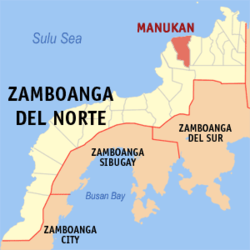 Location in the Philippines
 Municipality of Manukan
Coordinates: 8°32′N 123°06′E / 8.533°N 123.1°ECoordinates: 8°32′N 123°06′E / 8.533°N 123.1°E Country  Philippines
Region Western Mindanao (Region IX) Province [Zamboanga del Norte]] District 2nd District of Zamboanga del Norte Founded June16, 1951 Barangays 22 Government - Mayor - Vice-Mayor Population (2007) - Total 33,129 Time zone PHT (UTC+8) ZIP Code 7110 Area code(s) 065 Spoken languages Manukan(Filipino: Manukan, Subanon: Banukan) is a municipality in the province of Zamboanga del Norte in the Zamboanga Peninsula in the island of Mindanao, Philippines. A 3rd class municipality with population of 33,129[1]. It is located 38 kilometers west of Dipolog City, the provincial capital, and 282 kilometers westward to Zamboanga City, the regional capital. It is composed of a total of 22 barangays (smallest political subdivision) including the Central Poblacion where the municipal seat of power is located. Nine of the barangays are along the national highway and the rest are mountain barangays, being three or more kilometers away from the national highway that runs mostly along the coast of the municipality.
History
During the Pre-Spanish era this town was inhabited by Subanon. During the Spanish colonization, Manukan was a barrio part of Dapitan (now City of Dapitan). In the creation of municipality of Katipunan, this barrio was become a barangay Banukan. Chickens where plenty and perdominand breeds that supply the northern part of Mindanao come from this town. "Manukan" word means poultry farm. As population and economic stability improve. Birth of Municipality of Manukan was inaugurated on June16, 1951 by the virtue of Republic Act 655, duly sign by President Elpidio Quirino. In 1952, the barrios of Manukan, Lipras, Dipane, Linay, Mate, Sirongan, Libuton, Disakan, Siparok, Ponot, and Manawan of Katipunan were formed into the town of Manukan.[2]
Sitio Libuton became a barangay in 1954.[3]
Lipras was renamed Villa Ramos in 1957.[4]
Highway Barangays: east to west: San Antonio, Villa Ramos, Don Jose Aguirre, Linay, East Poblacion, Central Poblacion, Punta Blanca, Bogatong, Upper Disakan.
Mountain Barangays: Saluyong, Lupasang, Dipane, Gupot, Lingatongan, Meses, Mate, Libuton, Serongan, Pangandaw, Patagan, Palaranan, Suisayan.
References
- ^ "National Statistical Coordination Board". http://www.nscb.gov.ph/activestats/psgc/municipality.asp?muncode=097207000®code=09&provcode=72. Retrieved 2011-08-04.
- ^ "An Act Creating the Municipality of Manukan in the Province of Zamboanga". LawPH.com. http://lawph.com/statutes/ra655.html. Retrieved 2011-04-09.
- ^ "An Act to Create the Barrio of Libuton in the Municipality of Manucan, Province of Zamboanga Del Norte". LawPH.com. http://lawph.com/statutes/ra1109-creating-the-barrio-of-libuton,-manucan,-zamboanga-del-norte.html. Retrieved 2011-04-11.
- ^ "An Act Changing the Name of Barrio Lipras, Municipality of Manukan, Province of Zamboanga Del Norte, to Villa Ramos". LawPH.com. http://lawph.com/statutes/ra1667.html. Retrieved 2011-04-12.
External links
Municipalities Bacungan • Baliguian • Godod • Gutalac • Jose Dalman • Kalawit • Katipunan • La Libertad • Labason • Liloy • Manukan • Mutia • Piñan • Polanco • President Manuel A. Roxas • Rizal • Salug • Sergio Osmeña Sr. • Siayan • Sibuco • Sibutad • Sindangan • Siocon • Sirawai • TampilisanComponent cities Categories:- Municipalities of Zamboanga del Norte


Wikimedia Foundation. 2010.