- Buluan, Maguindanao
Infobox Settlement
official_name = Buluan, Maguindanao
other_name =
native_name =
nickname =
settlement_type =
motto =
imagesize =
image_caption =
flag_size =
image_
seal_size = 100px
image_shield =
shield_size =
city_
citylogo_size =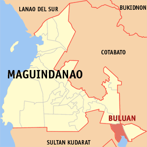
mapsize =
map_caption = Map ofMaguindanao showing the location of Buluan
mapsize1 =
map_caption1 =
pushpin_
pushpin_label_position =
pushpin_map_caption =
pushpin_mapsize =
subdivision_type = Country
subdivision_name =Philippines
subdivision_type1 = Region
subdivision_name1 =Autonomous Region in Muslim Mindanao
subdivision_type2 = Province
subdivision_name2 =Maguindanao
subdivision_type3 = Districts
subdivision_name3 = Lone district of Maguindanao
subdivision_type4 =Barangays
subdivision_name4 = 7
government_type =
leader_title = Mayor
leader_name = Datu Ibrahim G. Mangudadatu
leader_title1 =
leader_name1 =
established_title = Established
established_date =August 18 ,1947
established_title2 =
established_date2 =
established_title3 =
established_date3 =
area_magnitude =
unit_pref =
area_footnotes =
area_total_km2 =
area_land_km2 =
area_water_km2 =
area_total_sq_mi =
area_land_sq_mi =
area_water_sq_mi =
area_water_percent =
area_urban_km2 =
area_urban_sq_mi =
area_metro_km2 =
area_metro_sq_mi =
population_as_of = 2007
population_footnotes =
population_note =
population_total = 33,702
population_density_km2 =
population_density_sq_mi =
population_metro =
population_density_metro_km2 =
population_density_metro_sq_mi =
population_urban =
population_density_urban_km2 =
population_density_urban_sq_mi =
timezone = PST
utc_offset = +8
timezone_DST =
utc_offset_DST =
latd=6 |latm=43 |lats= 1|latNS=N
longd=124 |longm=46 |longs= 59|longEW=E
elevation_footnotes =
elevation_m = 14
elevation_ft =
postal_code_type = ZIP code
postal_code = 9616
area_code = 64
blank_name =
blank_info =
blank1_name =
blank1_info =
website = [http://www.buluan.gov.ph/ www.buluan.gov.ph]
footnotes = Buluan is a municipality in the province of Maguindanao,Philippines .Barangays
Buluan is politically subdivided into 7
barangay s. [cite web|url= http://www.nscb.gov.ph/activestats/psgc/municipality.asp?muncode=153803000®code=15&provcode=38|title= PSGC Interactive: Municipality/City: BULUAN|accessdate= 2008-05-19|author= National Statistical Coordination Board|date= |]
* Digal
* Lower Siling
* Maslabeng
* Poblacion
* Popol
* Talitay
* Upper SilingHistory
Buluan used to comprise a vast area surrounding
Lake Buluan when it was created as one of the municipalities ofCotabato onAugust 8 ,1947 by Executive Order No. 82 of Pres.Manuel Roxas . [cite web|url= http://www.coa.gov.ph/1999_AAR/Local_Govt/ARMM/Buluan99_es.htm|title= Executive Summary of the 1999 Annual Audit Report on the Municipality of Buluan|accessdate= 2008-05-19|author= Commission on Audit|date= |] OnAugust 3 ,1951 , the municipality ofTacurong was created out of its southwestern portion. [cite web|url= http://www.nscb.gov.ph/ru12/OVERVIEW/tacurong.htm|title= Brief Overview of Tacurong City|accessdate= 2008-05-19|author= National Statistical Coordination Board - Region XII|date= |] In1961 , its southeastern portion was separated to form the municipality ofColumbio , [cite web|url= http://www.columbio.gov.ph/|title= Glimpse of Columbio|accessdate= 2008-05-19|author= Commission on Audit|date= 2004-06-02|] six years later its southern portion was made into the municipality of Lutayan. [cite web|url= http://www.chanrobles.com/republicacts/republicactno4868.html|title= Republic Act No. 4868|accessdate= 2008-05-19|author= Chan Robles Virtual Law Library|date= 1998-07-19|] It was made part of the province ofMaguindanao onNovember 22 ,1973 , [cite web|url= http://www.chanrobles.com/presidentialdecrees/presidentialdecreeno341.html|title= Presidential Decree No. 341|accessdate= 2008-05-18|author= Chan Robles Virtual Law Library|date= 1998-07-19|] at the same time ceding its western coast of Lake Buluan to create the municipality of President Quirino, [cite web|url= http://www.chanrobles.com/presidentialdecrees/presidentialdecreeno339.html|title= Presidential Decree No. 339|accessdate= 2008-05-18|author= Chan Robles Virtual Law Library|date= 1998-07-19|] which was made part ofSultan Kudarat province. Its northern portion was made into the municipality of Gen. S.K. Pendatun onApril 7 ,1991 . [cite web|url= http://www.census.gov.ph/census2000/p153800.html|title= Census 2000 Final Counts|accessdate= 2008-05-19|author= National Statistics Office|date= 2001-04-23|] Its area was further divided onDecember 30 ,2006 , when two more municipalities were created out of its territory namely: Mangudadatu and Pandag, losing 8 barangays to each of the two new towns, [cite web|url= http://www.nscb.gov.ph/factsheet/pdf07/fs2_07.asp|title= 2007 Factsheet - Did you know that... ARMM now has six provinces|accessdate= 2008-05-19|author= National Statistical Coordination Board|date= 2007-03-26|] effectively losing its Lake Buluan coastline to the former. {|align="left"
Philippine Census
title= Population Census
1903=
1918=
1939=
1948=
1960=
1970=
1975=
1980=
1990=
1995= 20611
2000= 29841
2007= 32310
estimate=
estyear=
estref=
footnote= 1995 and 2000 figures exclude population of
areas now part ofMangudadatu andPandag .References
Wikimedia Foundation. 2010.