- 1852 Atlantic hurricane season
Infobox hurricane season
Basin=Atl
Year=1852
Track=1852 Atlantic hurricane season summary.jpg
First storm formed=August 19 ,1852
Last storm dissipated=October 11 ,1852
Strongest storm name=#1 –
Strongest storm winds=100
Average wind speed=1
Total storms=5
Total hurricanes=5
Total intense=1
Da
Inflated=0
Fatalities=100+ direct
five seasons=1850, 1851, 1852, 1853, 1854 The 1852 Atlantic hurricane season was one of only five Atlantic hurricane seasons in which every knowntropical cyclone attained hurricane status.cite web|author=Hurricane Research Division |year=2008|title=Best Track of Atlantic tropical cyclones (1851–2007)|publisher=National Oceanic and Atmospheric Administration|accessdate=2008-06-13|url=http://www.aoml.noaa.gov/hrd/hurdat/easyhurdat_5107.html] Five tropical cyclones were reported during the season, which lasted from late August through the middle of October; these dates fall within the range of most Atlantic tropical cyclone activity, and none of the cyclones coexisted with another. Though there were officially five tropical cyclones in the season, hurricane scholar Michael Chenoweth assessed two of the cyclones as being the same storm. There may have been other unconfirmed tropical cyclones during the season, as meteorologistChristopher Landsea estimated that up to six storms were missed each year from the official database; this estimate was due to small tropical cyclone size, sparse ship reports, and relatively unpopulated coastlines. [cite web|author=Chris Landsea |year=2007|title=Counting Atlantic Tropical Cyclones Back to 1900|publisher=American Meteorological Society|accessdate=2007-07-23|url=http://www.aoml.noaa.gov/hrd/Landsea/landsea-eos-may012007.pdf|format=PDF]Every tropical cyclone in the season was of hurricane status, or with winds at or exceeding 74 mph (119 km/h). In only five other seasons did every cyclone attain hurricane status; those years were 1858, 1866, 1884, 1929, and 1930. All five cyclones affected land; the strongest was the first storm, which caused severe damage and loss of life when it made landfall near the border between
Mississippi andAlabama . The second storm of the season struckPuerto Rico , where it caused over 100 deaths, primarily from flooding. In the middle of September, the third storm moved across Florida with strong wind gusts and light rainfall, and a week later the fourth storm passed over or north of the Lesser andGreater Antilles . The last storm hit the Florida Panhandle, though damage was less than expected.torms
Hurricane One
Infobox Hurricane Small
Basin=Atl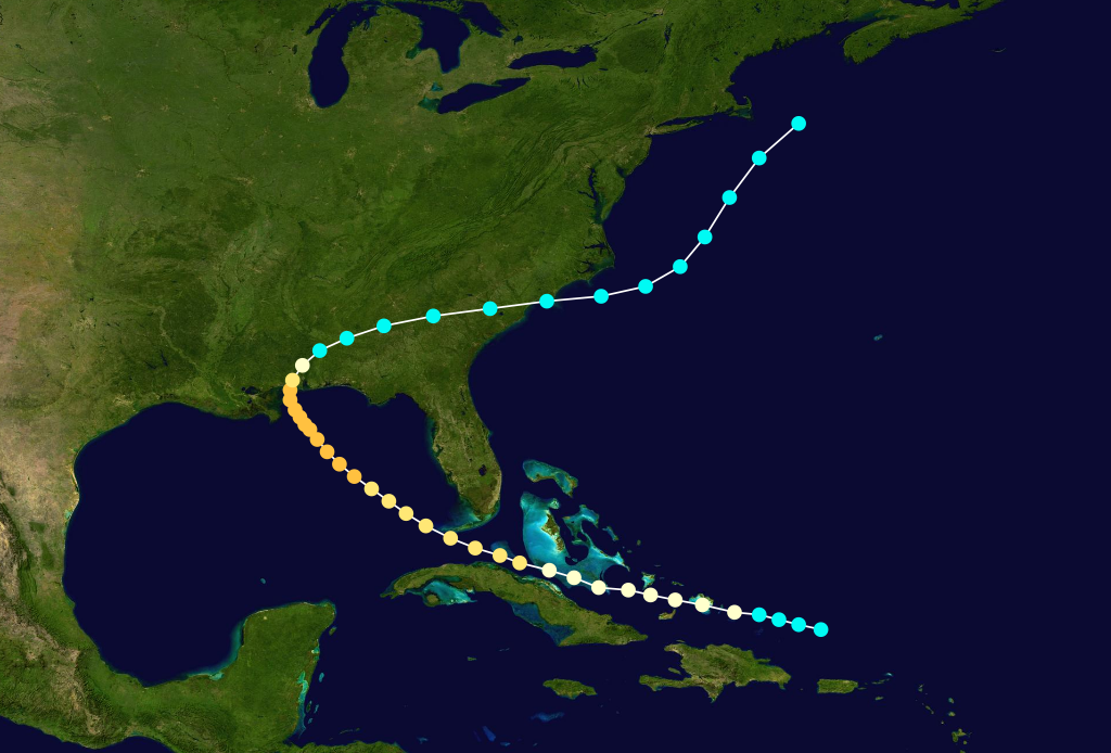
Formed=August 19
Dissipated=August 30
1-min winds=100
Pressure=961The first tropical cyclone of the year, also known as the "Great Mobile Hurricane of 1852", was first observed onAugust 19 about 140 mi (230 km) north ofPuerto Rico . It moved on a west-northwest motion before passing through theBahamas as it attained hurricane status onAugust 20 . After paralleling the northern coast ofCuba , the storm passed between theDry Tortugas andKey West, Florida onAugust 22 , and two days later it is estimated the hurricane attained peak winds of 115 mph (185 km/h). The storm slowed onAugust 25 before turning northward, and early onAugust 26 it made landfall nearPascagoula, Mississippi at peak strength, and the hurricane rapidly weakened to tropical storm status as it accelerated east-northeastward. OnAugust 28 it emerged into the Atlantic Ocean fromSouth Carolina , and after turning to the northeast, it was last observed onAugust 30 about 130 mi (200 km) southeast ofCape Cod .In the
Florida Keys , rough waves forced several ships ashore, leaving some damaged. [cite news|author=New York Daily Times|date=1852-09-03|title=Key West Hurricane Dispatch|accessdate=2008-06-17|url=http://www.thehurricanearchive.com/Viewer.aspx?] Strong waves created four new channels in the
Chandeleur Islands , and the storm's passage also destroyed the island lighthouse; the three keepers were found three days later. Two schooners were also washed ashore along Cat Island. [cite web|author=David M. Roth |year=1998|title=Louisiana Hurricane History: Late 19th Century|publisher=Lake Charles, Louisiana National Weather Service|accessdate=2008-06-17|url=http://www.srh.noaa.gov/lch/research/lalate19hu.php] The hurricane produced an estimatedstorm tide of 12 feet (3.7 m) inMobile, Alabama , where strong winds damaged much of the city, leaving the majority of the houses destroyed. Trees were downed up to 30 miles (50 km) inland,cite news|author=New York Daily Times|date=1852-08-31|title=From the South: The Gale in Mobile, Alabama|accessdate=2008-06-17|url=http://query.nytimes.com/mem/archive-free/pdf?_r=1&res=9F0CE2DE1231E13BBC4852DFBF668389649FDE&oref=slogin] and coastal areas were flooded. Damage along the coastline was estimated at around $1 million (1852 USD, $26 million 2008 USD), and several lives were lost. [cite news|author=Weekly Wisconsin|date=1852-08-29|title=Destructive Storm at Mobile|accessdate=2008-06-17|url=http://www.thehurricanearchive.com/Viewer.aspx?] While crossing the southeastern United States, the storm brought light rainfall but moderately strong winds; in
Charleston, South Carolina , the storm destroyed several bridges and crop fields.Hurricane Two
Infobox Hurricane Small
Basin=Atl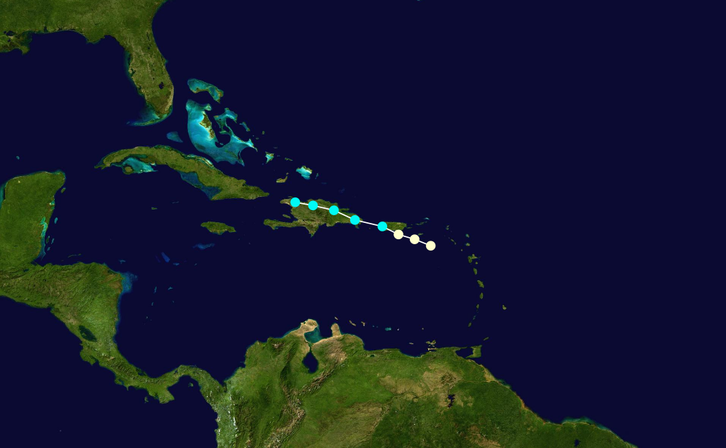
Formed=September 5
Dissipated=September 6
1-min winds=70
Pressure=Early onSeptember 5 , a hurricane was first observed about 65 mi (110 km) southeast ofChristiansted, United States Virgin Islands . One meteorologist assessed the hurricane as being located nearAntigua onSeptember 3 . Tracking steadily west-northwestward, it quickly moved ashore nearPonce, Puerto Rico with winds estimated at 80 mph (130 km/h). After crossing southwestern Puerto Rico, the hurricane emerged into theMona Passage as a tropical storm. Late onSeptember 5 it made landfall on easternDominican Republic ; it quickly weakened over Hispaniola, dissipating onSeptember 6 over the northwestern portion of the island. An assessment by scholar Michael Chenoweth in 2006 indicated this storm was the same as the next hurricane, with it continuing northwestward and ultimately reaching theGulf of Mexico .cite web|author=Michael Chenoweth|year=2006|title=A Reassessment of Historical Atlantic Basin Tropical Cyclone Activity, 1700-1855|publisher=Hurricane Research Division|accessdate=2008-05-25|url=http://www.aoml.noaa.gov/hrd/hurdat/Chenoweth/chenoweth06.pdf|format=PDF] Due to not being considered the same cyclone in the official hurricane database, this hurricane and the following hurricane are listed separately.The cyclone is known as the "San Lorenzo hurricane", due to its impact in Puerto Rico.cite web|author=
Hurricane Research Division |year=2008|title=Documentation of Atlantic Tropical Cyclones Changes in HURDAT|publisher=National Oceanic and Atmospheric Administration|accessdate=2008-06-14|url=http://www.aoml.noaa.gov/hrd/hurdat/metadata_master.html] There, the passage of the storm caused severe flooding, which destroyed large quantities of crops and damaged several roads. Storm damage was heaviest between Guayanilla and Mayagüez.cite web|author=Orlando Perez|year=1970|title=Notes on the Tropical Cyclones of Puerto Rico|publisher=National Weather Service|accessdate=2008-06-14|format=PDF|url=http://www.aoml.noaa.gov/hrd/data_sub/perez_11_20.pdf] More than 100 people were killed in Puerto Rico, [cite web|author=Edward N. Rappaport and Jose Fernandez-Partagas|year=1995|title=The Deadliest Atlantic Tropical Cyclones, 1492-1996|publisher=National Hurricane Center|accessdate=2008-06-14|url=http://www.nhc.noaa.gov/pastdeadlyapp1.shtml?] many of which due to flooding.Hurricane Three
Infobox Hurricane Small
Basin=Atl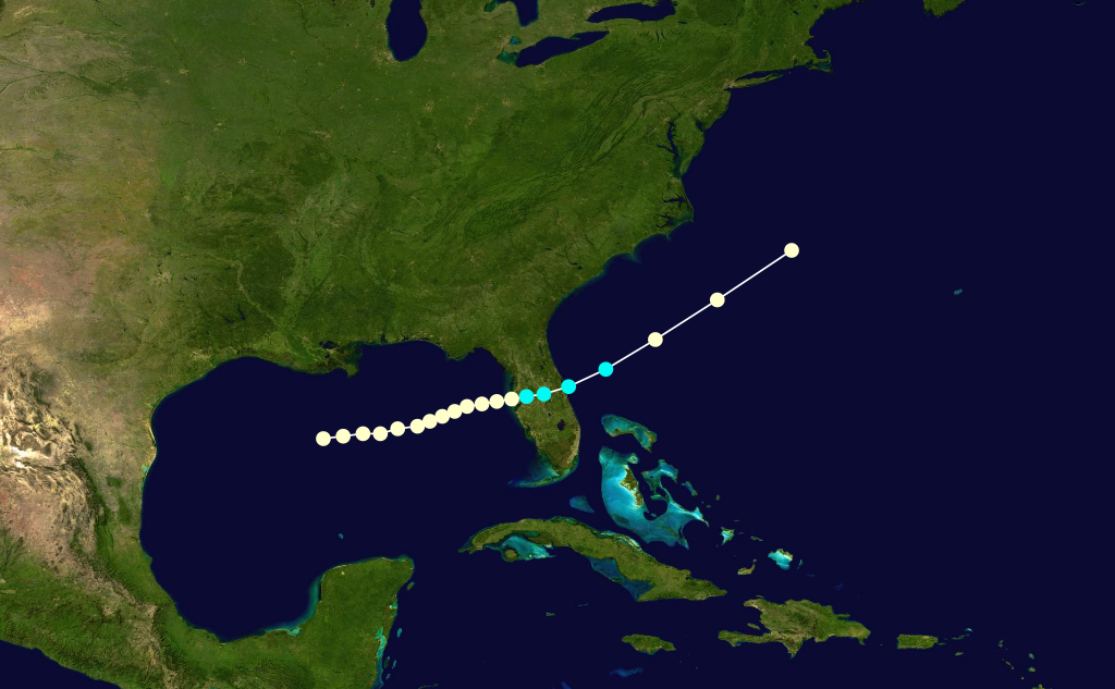
Formed=September 9
Dissipated=September 13
1-min winds=70
Pressure=985A hurricane was located in the centralGulf of Mexico onSeptember 9 , potentially the same hurricane as the previous storm. It tracked generally eastward toward the coast of Florida, with its hurricane intensity estimation based on two ship reports. At about 0000 UTC onSeptember 12 , it moved ashore nearClearwater, Florida as a minimal hurricane, with an estimated minimum barometric central pressure of 985 mbar. Accelerating east-northeastward while crossing the state, the cyclone emerged into the Atlantic Ocean as a weakened tropical storm before regaining hurricane status onSeptember 13 . Later that day, it was last observed about 250 mi (400 km) east-southeast ofCape Hatteras .A post in
Fort Meade, Florida reported at least 0.55 in (14 mm) of rainfall during the storm's passage. The hurricane was considered "violent", and gusts were estimated to have reached hurricane force. Rough seas and strong easterly winds beached a vessel near St. Augustine.cite web|author=Al Sandrik &Chris Landsea |year=2003|title=Chronological Listing of Tropical Cyclones affecting North Florida and Coastal Georgia 1565-1899|publisher=Hurricane Research Division |accessdate=2008-06-15|url=http://www.aoml.noaa.gov/hrd/Landsea/history/index.html]Hurricane Four
Infobox Hurricane Small
Basin=Atl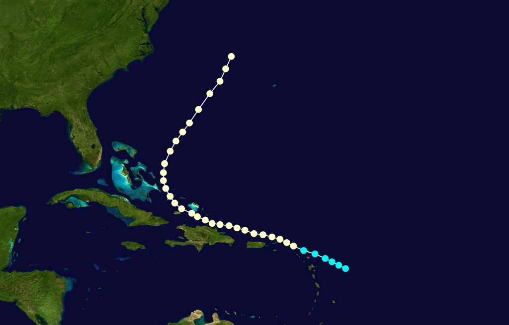
Formed=September 22
Dissipated=September 30
1-min winds=80
Pressure=OnSeptember 22 , a tropical storm was located about 200 mi (330 km) east ofGuadeloupe . With a steady west-northwest path, the storm moved across the northernLesser Antilles onSeptember 23 , during which it intensified into a hurricane. It passed a short distance north ofPuerto Rico and theDominican Republic as it reached its peak intensity of 90 mph (150 km). Late onSeptember 26 the hurricane turned northwestward, bringing it through theTurks and Caicos Islands and easternBahamas . Recurving north-northeastward, the cyclone moved into open waters, and was last classified as a tropical cyclone onSeptember 30 about 390 mi (630 km) east ofCape Hatteras . However, one hurricane researcher assessed the hurricane as lasting untilOctober 3 , with the cyclone turning eastward and dissipating near theAzores .Hurricane Five
Infobox Hurricane Small
Basin=Atl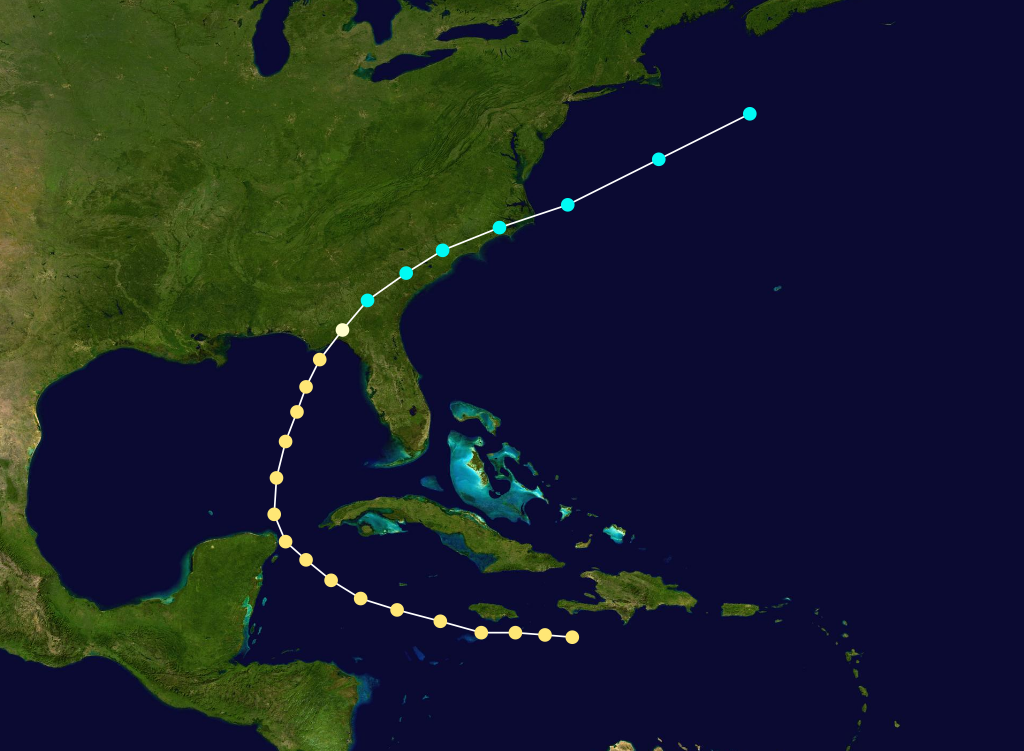
Formed=October 6
Dissipated=October 11
1-min winds=90
Pressure=969A moderately strong hurricane with winds of 105 mph (165 km/h) was first spotted onOctober 6 east ofJamaica . Passing a short distance south of the island, the hurricane tracked northwestward and brushed theYucatán Peninsula before turning north-northeastward into theGulf of Mexico . Late onOctober 9 , it made landfall a short distance east ofApalachicola, Florida at peak winds with an estimated pressure of 969 mbar. [cite web|author=Hurricane Research Division |year=2008|title=Continental U.S. Hurricanes: 1851 to 1920|accessdate=2008-06-18|url=http://www.aoml.noaa.gov/hrd/hurdat/usland1851-1920.html] Rapidly weakening to tropical storm status, the cyclone continued northeastward and emerged into the Atlantic Ocean from North Carolina onOctober 11 . Later that day, it was last observed about 250 mi (400 km) southeast of Cape Cod.Heavy damage was reported in Jamaica. Upon making landfall in Florida, the hurricane produced a 7 ft (2 m)
storm tide , and in Georgia, hurricane force winds extended into the southwestern portion of the state, while tropical storm force winds occurred along the coastline. In the state, moderate winds damaged trees and roofs, though the destruction was less than anticipated.ee also
*
List of Atlantic hurricane seasons
*List of Atlantic hurricanes References

Wikimedia Foundation. 2010.