Nanboku Line (Sendai)

Nanboku Line (Sendai)
The Sendai City Subway logo
Sendai City Subway Line
Legend
km Station
End station
14.8 Tomizawa

The Sendai City Subway Line (or Sendai City Underground Nanboku Line (仙台市営地下鉄南北線 Sendai shiei chikatetsu nanbokusen?) as it is officially known) is a subway line in Sendai, Miyagi Prefecture, Japan. It connects Izumi-chūō Station in Izumi-ku, Sendai, with Tomizawa Station in Taihaku-ku, Sendai. This 1067 mm gauge line is 14.8 km long has 17 stations and runs on 1500 volt underground overhead electric system. The name Nanboku means north-south, which is the general direction that the track runs.

The Nanboku Line was the world's first public train to use fuzzy logic to control its speed, and is often used as an example in university courses on the subject of neural networks. This system (developed by Hitachi)[1] accounts for the relative smoothness of the starts and stops when compared to other trains, and is 10% more energy efficient than human-controlled acceleration[2].


Contents

History

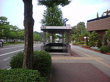
An entrance leading down to Dainohara Station
  • 1981 - Construction Started
  • July 15, 1987 - From Yaotome Station to Tomizawa Station opened.
  • July 15, 1992 - Line extended from Yaotome Station to Izumi-Chūō Station.
  • March 11, 2011 - Damaged in the 2011 Tōhoku earthquake and tsunami and subsequently shut down for repairs.
  • April 29, 2011 - Line reopenes after repair works were finished.[3]


Nanboku Line Station List

Station Name Japanese Distance from previous station Distance from Tomizawa Coordinates Transfers Location
Tomizawa 富沢 N/A 0.0 km 38°12′51″N 140°52′14″E / 38.214167°N 140.870556°E / 38.214167; 140.870556 (Tomizawa Station) Taihaku-ku, Sendai
Nagamachi-Minami 長町南 1.5 km 1.5 km 38°13′29″N 140°52′36″E / 38.224722°N 140.876667°E / 38.224722; 140.876667 (Nagamachi-Minami Station)
Nagamachi 長町 0.9 km 2.4 km 38°13′35″N 140°53′08″E / 38.226389°N 140.885556°E / 38.226389; 140.885556 (Nagamachi Station) Tōhoku Main Line, Jōban Line
Nagamachi-Itchōme 長町一丁 0.7 km 3.1 km 38°14′03″N 140°53′15″E / 38.234167°N 140.8875°E / 38.234167; 140.8875 (Nagamachi-Itchōme Station)
Kawaramachi 河原町 0.8 km 3.9 km 38°14′28″N 140°53′16″E / 38.241111°N 140.887778°E / 38.241111; 140.887778 (Kawaramachi Station) Wakabayashi-ku, Sendai
Atagobashi 愛宕橋 0.9 km 4.8 km 38°14′51″N 140°52′54″E / 38.2475°N 140.881667°E / 38.2475; 140.881667 (Atagobashi Station)
Itsutsubashi 五橋 0.6 km 5.4 km 38°15′07″N 140°52′52″E / 38.251944°N 140.881111°E / 38.251944; 140.881111 (Itsutsubashi Station) Aoba-ku, Sendai
Sendai 仙台 0.9 km 6.3 km 38°15′37″N 140°52′55″E / 38.260278°N 140.881944°E / 38.260278; 140.881944 (Sendai Station) Tōhoku Shinkansen, Tōhoku Main Line, Senzan Line, Senseki Line (at Aoba-dōri Station), Jōban Line
Hirose-dōri 広瀬通 0.6 km 6.9 km 38°15′46″N 140°52′33″E / 38.262778°N 140.875833°E / 38.262778; 140.875833 (Hirose-dōri Station)
Kōtōdai-Kōen 勾当台公園 0.6 km 7.5 km 38°15′59″N 140°52′17″E / 38.266389°N 140.871389°E / 38.266389; 140.871389 (Kōtōdai-Kōen Station)
Kita-Yobanchō 北四番丁 0.7 km 8.2 km 38°16′20″N 140°52′08″E / 38.272222°N 140.868889°E / 38.272222; 140.868889 (Kita-Yobanchō Station)
Kita-Sendai 北仙台 1.2 km 9.4 km 38°16′54″N 140°52′09″E / 38.281667°N 140.869167°E / 38.281667; 140.869167 (Kita-Sendai Station) Senzan Line
Dainohara 台原 1.1 km 10.5 km 38°17′19″N 140°52′43″E / 38.288611°N 140.878611°E / 38.288611; 140.878611 (Dainohara Station)
Asahigaoka 旭ヶ丘 1.0 km 11.5 km 38°17′45″N 140°53′01″E / 38.295833°N 140.883611°E / 38.295833; 140.883611 (Asahigaoka Station)
Kuromatsu 黒松 0.8 km 12.3 km 38°18′11″N 140°53′11″E / 38.303056°N 140.886389°E / 38.303056; 140.886389 (Kuromatsu Station) Izumi-ku, Sendai
Yaotome 八乙女 1.3 km 13.6 km 38°18′47″N 140°53′03″E / 38.313056°N 140.884028°E / 38.313056; 140.884028 (Yaotome Station)
Izumi-Chūō 泉中央 1.2 km 14.8 km 38°19′23″N 140°52′50″E / 38.323056°N 140.880556°E / 38.323056; 140.880556 (Izumi-Chūō Station)

Rolling stock

  • 1000 series

See also

References

  1. ^ Andrew Pollack (April 2, 1989). "Fuzzy Computer Theory: How to Mimic the Mind?". The New York Times. http://query.nytimes.com/gst/fullpage.html?res=950DE5DF133EF931A35757C0A96F948260&sec=&spon=&pagewanted=print. Retrieved 2007-10-31. 
  2. ^ Philip Elmer-DeWitt (September 25, 1989). "Time For Some Fuzzy Thinking". Time. http://www.time.com/time/magazine/article/0,9171,958640,00.html. Retrieved 2007-10-31. 
  3. ^ Kyodo News, "Sendai subway to fully resume operation April 29, earlier than planned", 6 April 2011.

External links


Wikimedia Foundation. 2010.

Игры ⚽ Поможем написать реферат

Look at other dictionaries:

  • Sendai Station (Miyagi) — infobox japan station namerom=Sendai name= 仙台 imagesize= caption= Sendai Station pref= Miyagi city= Sendai ward= Aoba town= village= district= address= jaloc= 宮城県仙台市青葉区中央1丁目 postal= open= 1887 close= oldname= presentname= station number= operator …   Wikipedia

  • Sendai Subway — The nihongo|Sendai Subway|仙台市営地下鉄|Sendai shiei Chikatetsu consists of one line, the Nanboku Line. Construction of a second line, the Tōzai Line, began in 2004 with a planned opening date of 2015. The Sendai City Transportation Bureau operates the …   Wikipedia

  • Sendai City Transportation Bureau — nihongo|Sendai City Transportation Bureau|仙台市交通局|Sendai shi Kōtsūkyoku is a public organization of transportation in Sendai, Japan. The organization operates subways and buses. It was founded in 1926.Transportations*Sendai City Bus **Loople… …   Wikipedia

  • Sendai Gymnasium — nihongo|Sendai Gymnasium|仙台市体育館|Sendai shi Taiikukan is an indoor sporting arena located in Sendai, Miyagi, Japan. The capacity of the arena is 7,000. It hosted preliminary round games for the Basketball World Championship 2006, and is also the… …   Wikipedia

  • North–South Line — The North–South Line may refer to several different railway lines: The North–South Line of the KTM Intercity service in Malaysia The North South MRT Line of the Mass Rapid Transit in Singapore The North/South Line (Amsterdam metro) of the… …   Wikipedia

  • Namboku Line — can refer to one of several Japanese railway lines. The name literally means North South Line . The following lines exist:*Namboku Line (Osaka) (Kita Osaka Kyuko Railway) *Namboku Line (Kobe) (Kobe Rapid Railway) *Namboku Line (Sapporo) (Sapporo… …   Wikipedia

  • Aoba-ku, Sendai — nihongo|Aoba ku|青葉区 is one of five wards of Sendai, the largest city in the Tōhoku region of Japan. Aoba ku encompasses 302.28km² and had a population of 282,903 as of August 12005.Government, transportation, and commerceThe Miyagi Prefecture… …   Wikipedia

  • Kita-Sendai Station — nihongo|Kita Sendai Station|北仙台駅|Kita Sendai eki is a station on the JR Senzan Line and the Sendai Subway Nanboku Line in Aoba ku, Sendai, Miyagi Prefecture, Japan. The subway and JR lines are not directly connected, however, the distance between …   Wikipedia

  • Senseki Line — The nihongo|Senseki Line|仙石線|Senseki sen is a rail line in Miyagi Prefecture, Japan. Part of the East Japan Railway Company (JR East) system, it runs from Aoba dōri Station in Sendai to Ishinomaki Station in Ishinomaki, and provides access to the …   Wikipedia

  • Taihaku-ku, Sendai — nihongo|Taihaku ku|太白区 is a ward located in Sendai in Miyagi, Japan.As of 2005, the ward has an estimated population of 223,530 and the density of 979.49 persons per km sup2;. The total area is 228.21 km².TransportationTrain stations* JR East… …   Wikipedia

Share the article and excerpts

Direct link
Do a right-click on the link above
and select “Copy Link”