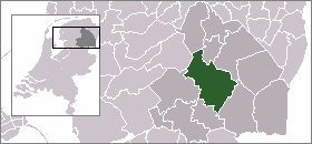
- Midden-Drenthe
-
Midden-Drenthe — Municipality — 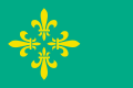
Flag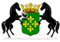
Coat of arms
Coordinates: 52°52′N 6°31′E / 52.867°N 6.517°ECoordinates: 52°52′N 6°31′E / 52.867°N 6.517°E Country Netherlands Province Drenthe Area(2006) - Total 345.82 km2 (133.5 sq mi) - Land 341.53 km2 (131.9 sq mi) - Water 4.29 km2 (1.7 sq mi) Population (1 January, 2007) - Total 33,571 - Density 98/km2 (253.8/sq mi) Source: CBS, Statline. Time zone CET (UTC+1) - Summer (DST) CEST (UTC+2) Midden-Drenthe (
 pronunciation (help·info)) is a municipality in the northeastern Netherlands. The municipality was created in 1998, in a merger of the former municipalities of Beilen, Smilde, and Westerbork. Between 1998 and 2000, the name of the municipality was Middenveld.
Population centres
Balinge, Beilen, Bovensmilde, Brunsting, Bruntinge, Drijber, Elp, Eursinge, Garminge, Hijken, Hijkersmilde, Holthe, Hoogersmilde, Hooghalen, Laaghalen, Laaghalerveen, Lieving, Makkum, Mantinge, Nieuw-Balinge, Oranje (Drenthe), Orvelte, Smalbroek, Smilde, Spier, Terhorst, Westerbork, Wijster, Witteveen, Zuidveld and Zwiggelte.
The village of Westerbork gives its name to the Westerbork deportation and (later) concentration camp, located about 7 km north of the village, in the forests of Hooghalen.
The Westerbork Synthesis Radio Telescope (WSRT) array was installed near the site of the camp in 1969.
External links
Aa en Hunze · Assen · Borger-Odoorn · Coevorden · De Wolden · Emmen · Hoogeveen · Meppel · Midden-Drenthe · Noordenveld · Tynaarlo · Westerveld

See also: Netherlands · Provinces · Municipalities Categories:- Municipalities of Drenthe
- Drenthe geography stubs


Wikimedia Foundation. 2010.