- Mystic, Iowa
-
Mystic, Iowa — City — Location of Mystic, Iowa
Coordinates: 40°46′43″N 92°56′42″W / 40.77861°N 92.945°WCoordinates: 40°46′43″N 92°56′42″W / 40.77861°N 92.945°W Country USA State  Iowa
IowaCounty Appanoose Area – Total 2.9 sq mi (7.6 km2) – Land 2.9 sq mi (7.6 km2) – Water 0.0 sq mi (0.0 km2) Elevation 899 ft (274 m) Population (2000) – Total 588 – Density 200.7/sq mi (77.5/km2) Time zone Central (CST) (UTC-6) – Summer (DST) CDT (UTC-5) ZIP code 52574 Area code(s) 641 FIPS code 19-55200 GNIS feature ID 0459427 Mystic is a city in Appanoose County, Iowa, United States. The population was 588 at the 2000 census.
Contents
History
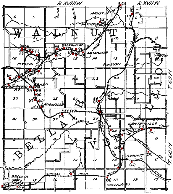
 Map of the Mystic and Brazil area from 1908, showing the railroads and shipping coal mines (shown in red) of the region. Mystic and Brazil are in the upper left quadrant. Smaller mines that did not ship by rail are not shown.
At the end of the 19th century, "the valley of Walnut Creek was one continuous mining camp, known under different names, Jerome, Diamond, Mystic, Clarksdale, Rathbun and Darby" (later known as Darbyville).[1] A. M. Elgin opened the first coal mine in the Mystic area in 1857, about 1.5 miles north of Mystic on Little Walnut Creek. The Mystic coal seam was exposed on the surface there, and drifts were opened and abandoned over the next few decades until the hills were honeycombed with mines.
In 1858, Isaac Fuller opened a large mine in Mystic, shipping coal for domestic use in nearby Centerville. In 1887, the Chicago, Milwaukee and St. Paul Railway built a line through Mystic, leading to an explosive growth in mining.[2] By 1893, there were 14 mines in Mystic and 2 in Brazil, just to the south. [3] It is noteworthy that the terms brass, brazzle and brazil are English dialect terms for pyrite or to coal seams with significant pyrite content[4] and that a shale layer not far above the Mystic coal seam in Mystic and Brazil contains significant pyrite.[5]
Local Assembly 3335 of the Knights of Labor was based in Brazil and had a membership of 75 in 1884.[6] The miners of Mystic and Brazil joined the United Mine Workers in 1898. By 1902, Local 201 in Brazil had 220 members and Local 634 in Mystic had 569 members.[7] By 1912, Local 201 had 370 members and Locals 239 and 634 in Mystic had a combined membership of 851.[8] The total UMWA membership in 1912 represents about 1/4 of the entire population.
In 1914, the Lodwick Brothers Coal Company of Mystic produced over 100,000 tons of coal, ranking among the top 24 coal producers in the state.[9]
Geography
Mystic's longitude and latitude coordinates
in decimal form are 40.778616, −92.944933. [10]
Mystic is located in the valley of Walnut Creek, about 4 miles southwest of its confluence with the Chariton River.According to the United States Census Bureau, the city has a total area of 2.9 square miles (7.5 km2), all of it land.
Demographics
Historical populations Census Pop. %± 1890 875 — 1900 1,758 100.9% 1910 2,663 51.5% 1920 2,796 5.0% 1930 1,953 −30.2% 1940 1,822 −6.7% 1950 1,233 −32.3% 1960 761 −38.3% 1970 696 −8.5% 1980 665 −4.5% 1990 545 −18.0% 2000 588 7.9% Total Population of Iowa's Incorporated Places 1850–2000 As of the census[11] of 2000, there were 588 people, 236 households, and 159 families residing in the city. The population density was 200.7 people per square mile (77.5/km²). There were 273 housing units at an average density of 93.2 per square mile (36.0/km²). The racial makeup of the city was 99.15% White, 0.17% Native American, and 0.68% from two or more races.
There were 236 households out of which 32.2% had children under the age of 18 living with them, 55.1% were married couples living together, 7.6% had a female householder with no husband present, and 32.6% were non-families. 25.8% of all households were made up of individuals and 10.6% had someone living alone who was 65 years of age or older. The average household size was 2.49 and the average family size was 2.99.
In the city the population was spread out with 25.3% under the age of 18, 6.1% from 18 to 24, 30.1% from 25 to 44, 24.8% from 45 to 64, and 13.6% who were 65 years of age or older. The median age was 37 years. For every 100 females there were 101.4 males. For every 100 females age 18 and over, there were 109.0 males.
The median income for a household in the city was $25,568, and the median income for a family was $29,063. Males had a median income of $26,964 versus $18,500 for females. The per capita income for the city was $11,846. About 22.3% of families and 22.9% of the population were below the poverty line, including 25.2% of those under age 18 and 15.7% of those age 65 or over.
References
- ^ H. Foster Bain, Geology of Appanoose County, Iowa Geological Survey Annual Report, 1895 Conway, Des Moines, 1896; page 389.
- ^ James H. Lees, History of Coal Mining in Iowa, Chapter III of Annual Report, 1908, Iowa Geological Survey, 1909, pages 534–535.
- ^ Sixth Biennial Report of the State Mine Inspector to the Governor of the State of Iowa for the Two Years Ending June 30, 1893, Ragsdale, Des Moines, 1893 ,page 11.
- ^ Julia A. Jackson, James Mehl and Klaus Neuendorf, Glossary of Geology, American Geological Institute, 2005; page 82.
- ^ H. Foster Bain, Geology of Appanoose County, Iowa Geological Survey Annual Report, 1895 Conway, Des Moines, 1896; page 389.
- ^ Part III, Labor Organizations: Knights of Labor, First Biennial Report of the Bureau of Labor Statistics for the State of Iowa, Geo. E. Roberts, Des Moines, 1885; page 55.
- ^ Trade Unions in Iowa – Table No. 1, Mine Workers of America, United, Tenth Biennial Report of the Bureau of Labor Statistics for the State of Iowa, 1901–1902, Murphy, Des Moines, 1903; page 232.
- ^ Tally Sheet, Proceedings of the 23rd Annual Convention of the United Mine Workers of America Jan. 16 – Feb. 2, 1912, Indianapolis; Volume 2, pages 180A-182A.
- ^ Frederick E. Saward, The Coal Trade, 1915, page 65.
- ^ "US Gazetteer files: 2010, 2000, and 1990". United States Census Bureau. 2011-02-12. http://www.census.gov/geo/www/gazetteer/gazette.html. Retrieved 2011-04-23.
- ^ "American FactFinder". United States Census Bureau. http://factfinder.census.gov. Retrieved 2008-01-31.
External links
- City-Data Comprehensive statistical data and more about Mystic
Municipalities and communities of Appanoose County, Iowa Cities Centerville | Cincinnati | Exline | Moravia | Moulton | Mystic | Numa | Plano | Rathbun | Udell | Unionville

Townships Categories:- Populated places in Appanoose County, Iowa
- Cities in Iowa

Wikimedia Foundation. 2010.