- Mystic Valley Parkway
-
Mystic Valley Parkway, Metropolitan Park System of Greater Boston MPS
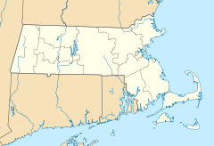

Location: Arlington, Medford, Somerville, and Winchester, Massachusetts Coordinates: 42°25′47″N 71°7′49″W / 42.42972°N 71.13028°WCoordinates: 42°25′47″N 71°7′49″W / 42.42972°N 71.13028°W Area: 22 acres (8.9 ha) Built: 1936 Architect: Charles Eliot; Olmsted Brothers Governing body: State (Department of Conservation and Recreation) MPS: Metropolitan Park System of Greater Boston MPS NRHP Reference#: 05001529[1] Added to NRHP: January 18, 2006 Mystic Valley Parkway is a short parkway in Arlington, Medford, Somerville, and Winchester, Massachusetts. It is listed on the National Register of Historic Places, and forms part of Route 16.
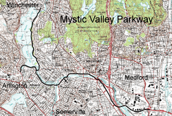
The parkway runs roughly north-south from the Middlesex Fells in Winchester, down the Aberjona River valley, and along the east side of the Mystic Lakes into Medford. This section follows the path of the old Middlesex Canal. It then crosses the Mystic River into Arlington (sharing a bridge with Massachusetts Route 60), and curves to follow the river as it runs east-west through Arlington. A short branch also runs along the southern shore of the Lower Mystic Lake from Route 60 where it ends at a junction with U.S. Route 3 and Massachusetts Route 2A. It meets the Alewife Brook Parkway (and joins with Massachusetts Route 16) at a rotary near where Alewife Brook empties into the Mystic, and then continues to generally follow the course of the Mystic River downstream, crossing it several times before ending at the Revere Beach Parkway where both meet Massachusetts Route 28.
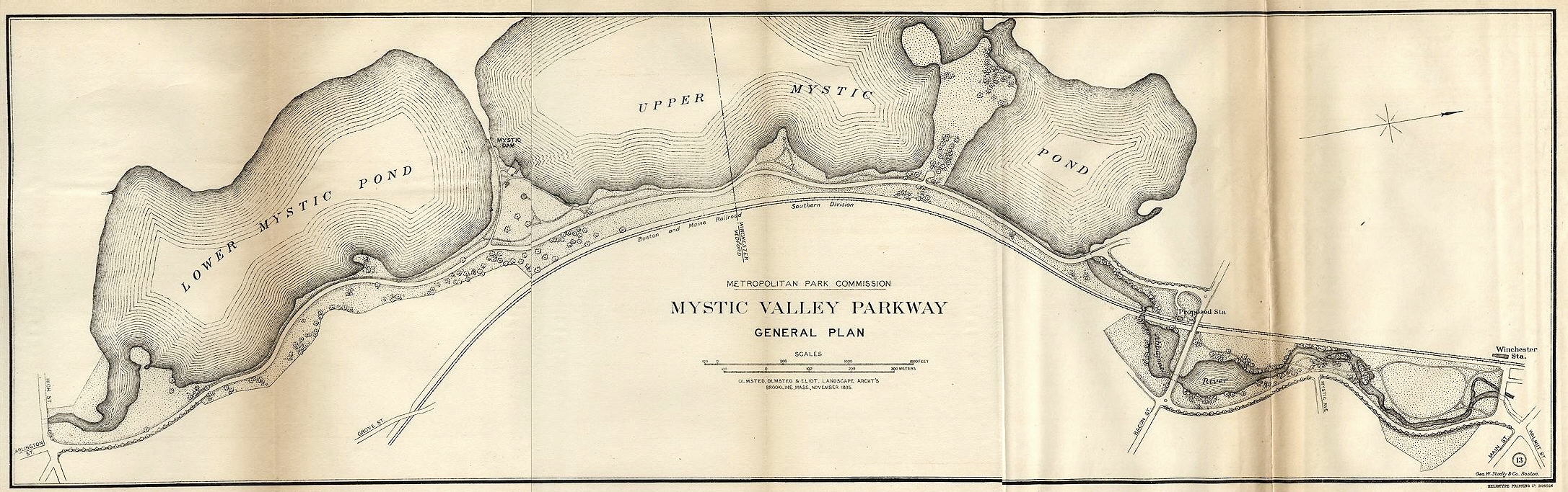
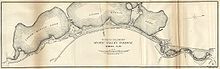 The Olmsted plan of the original parkway, 1895.
The parkway, with surrounding landscape, forms part of Boston's Metropolitan Park District, established in 1893. The parkway itself was designed in 1894-1895 by the Olmsted Brothers, the noted landscape architects, with Charles Eliot taking a lead role. It was originally created as one section of a web of pleasure roads designed for their aesthetics, as part of a comprehensive plan for green spaces in and around Boston.
It now forms part of the Metropolitan Park System of Greater Boston, and on January 18, 2006, was added to the National Register of Historic Places as a historic district.
References
- ^ "National Register Information System". National Register of Historic Places. National Park Service. 2009-03-13. http://nrhp.focus.nps.gov/natreg/docs/All_Data.html.
- Charles Eliot, "The Boston Metropolitan Reservations", The New England magazine, Volume 21, Issue 1, September 1896.
- William B. de las Casas, "The Boston Metropolitan Park System", Annals of the American Academy of Political and Social Science, Vol. 35, No. 2, Public Recreation Facilities (March, 1910), pp. 64–70.
- Charles William Eliot, Charles Eliot: Landscape Architect, Houghton, Mifflin, 1902.
U.S. National Register of Historic Places Topics Lists by states Alabama • Alaska • Arizona • Arkansas • California • Colorado • Connecticut • Delaware • Florida • Georgia • Hawaii • Idaho • Illinois • Indiana • Iowa • Kansas • Kentucky • Louisiana • Maine • Maryland • Massachusetts • Michigan • Minnesota • Mississippi • Missouri • Montana • Nebraska • Nevada • New Hampshire • New Jersey • New Mexico • New York • North Carolina • North Dakota • Ohio • Oklahoma • Oregon • Pennsylvania • Rhode Island • South Carolina • South Dakota • Tennessee • Texas • Utah • Vermont • Virginia • Washington • West Virginia • Wisconsin • WyomingLists by territories Lists by associated states Other Metropolitan Park System of Greater Boston Coastal reservations Belle Isle Marsh • Boston Harbor Islands • Castle Island • Dorchester Shores • Fort Revere Park • Lynn Shore • Nahant Beach • Nantasket Beach • Quincy Shore • Revere Beach • Rumney Marsh • Webb Memorial State Park • Weymouth Back RiverRiver reservations Alewife Brook • Charles River • Chestnut Hill • Cutler Park • Elm Bank • Hemlock Gorge • Mystic River • Neponset River • Pope John Paul II Park • Squantum Point Park • Upper Charles RiverWoodland reservations Beaver Brook • Blue Hills • Breakheart • Hammond Pond • Middlesex Fells • Quincy Quarries • Southwest Corridor Park • Stony Brook • Wilson MountainHeritage state parks Lynn Heritage State Park • Roxbury Heritage State ParkParkways and roads Alewife Brook Parkway · Arborway · Blue Hills Parkway · Blue Hills Reservation Parkways · Charles River Reservation Parkways · Day Boulevard · Fells Connector Parkways · Fenway · Fresh Pond Parkway · Furnace Brook Parkway · Hammond Pond Parkway · Hull Shore Drive · Jamaicaway · Lynn Fells Parkway · Memorial Drive · Morrissey Boulevard · Mystic Valley Parkway · Nahant Beach Boulevard · Nantasket Avenue · Park Drive · Quincy Shore Drive · Revere Beach Parkway · Riverway · Soldiers Field Road · Stony Brook Reservation Parkways · Storrow Drive · Truman Parkway · VFW Parkway · West Roxbury Parkway • Winthrop Parkway • Winthrop Shore DriveCategories:- Historic districts in Massachusetts
- Parkways in Massachusetts
- Transportation in Middlesex County, Massachusetts
- Roads on the National Register of Historic Places in Massachusetts
- Buildings and structures in Arlington, Massachusetts
- Buildings and structures in Somerville, Massachusetts
- Buildings and structures in Winchester, Massachusetts

Wikimedia Foundation. 2010.