- Geography of Mauritius
-
Mauritius Native name: Maurice
Nickname: The Star and Key of the Indian Ocean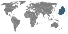
Location of Mauritius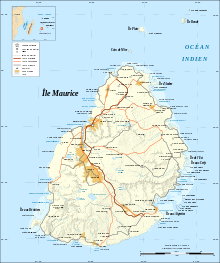
Geography Location Indian Ocean Coordinates 20°17′S 57°33′E / 20.283°S 57.55°E Archipelago Mascarene Islands Area 2,030 km2 (784 sq mi) Highest elevation 828 m (2,717 ft) Highest point Piton de la Petite Rivière Noire Country MauritiusLargest city Port Louis (pop. 147,688) Demographics Population 1,264,866 (as of 2007) Density 616 /km2 (1,595 /sq mi) Ethnic groups Indo-Mauritian 68%, Mauritian Creole people 27%, Sino-Mauritian 3%, Franco-Mauritian 2% Contents
Climate
The local climate is tropical, modified by southeast trade winds; there is a warm, dry winter from May to November and a hot, wet, and humid summer from November to May. Anti-cyclones affect the country during May to September. Cyclones affect the country during November-April. Hollanda (1994) and Dina (2002) were the worst two last cyclones to have affected the island.
Statistics
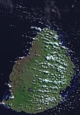 Satellite image of Mauritius
Location: Southern Africa, island in the Indian Ocean, east of Madagascar Geographic coordinates: 20°17′S 57°33′E / 20.283°S 57.55°E
Map references: World
Area (includes Agalega Islands, Cargados Carajos Shoals (Saint Brandon), and Rodrigues):
total: 2,040 km²
land: 2,030 km²
water: 10 km²Area - comparative: almost 11 times the size of Washington, D.C.
Land boundaries: 0 km
Coastline: 177 km
Maritime claims:
continental shelf: 200 nmi (370.4 km; 230.2 mi) or to the edge of the continental margin
exclusive economic zone: 200 nmi (370.4 km; 230.2 mi)
territorial sea: 12 nmi (22.2 km; 13.8 mi)Terrain: small coastal plain rising to discontinuous mountains encircling central plateau
Elevation extremes:
lowest point: Indian Ocean 0 m
highest point: Piton de la Petite Rivière Noire 828 mNatural resources: arable land, fish
Land use:
arable land: 49.26%
permanent crops: 2.96%
permanent pastures: 3%
forests and woodland: 22%
other: 23% (1993 est.)Irrigated land: 200 km² (1998 est.)
Natural hazards: cyclones (November to April); almost completely surrounded by reefs that may pose maritime hazards
Environment - current issues: water pollution, degradation of coral reefs
Environment - international agreements:
party to: Biodiversity, Climate Change, Climate Change-Kyoto Protocol, Desertification, Endangered Species, Environmental Modification, Hazardous Wastes, Law of the Sea, Marine Life Conservation, Nuclear Test Ban, Ozone Layer Protection, Ship Pollution, Wetlands
signed, but not ratified: none of the selected agreementsGeography - note: The main island, from which the country derives its name, is of volcanic origin and is almost entirely surrounded by coral reefs
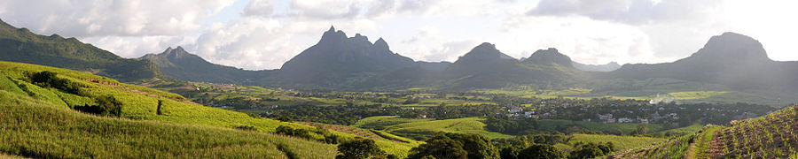

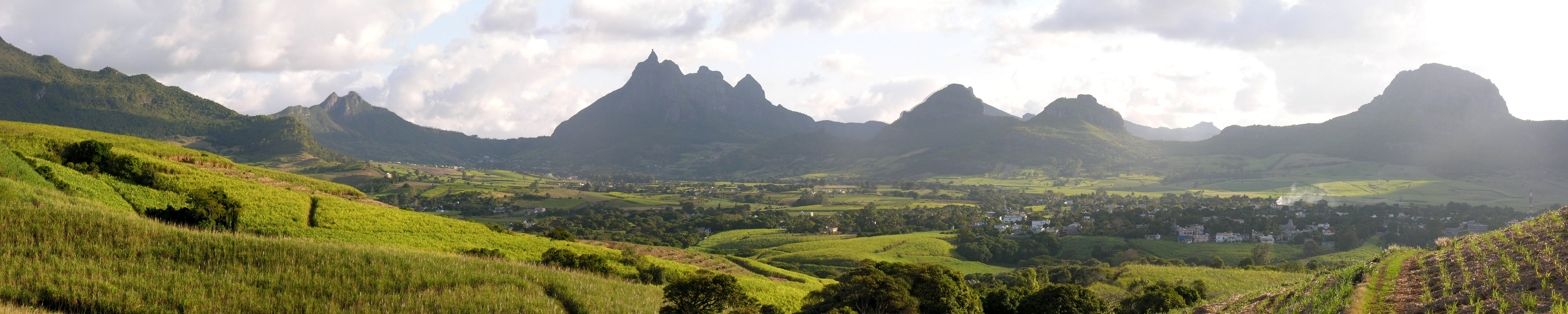
Landscape near Les Mariannes. Extreme points
This is a list of the extreme points of Mauritius, the points that are farther north, south, east or west than any other location.
- Northern-most point – Tappe à Terre, North Island, Agalega Islands
- Eastern-most point – Trou d’Argent, Rodrigues Island
- Southern-most point - Le Gris Gris, Savanne District, Mauritius
- Western-most point - North West Point, North Island, Agalega Islands
See also
- Mauritius
- Mauritius Travel Information (english)
Links to related articles  Mauritius topics
Districts Black River · Flacq · Grand Port · Moka · Pamplemousses · Plaines Wilhems · Port Louis · Rivière du Rempart · Savanne
Dependencies and
territoriesTerritorial claims Politics and
governmentEconomy People Religion Culture Other topics Sovereign
states- Algeria
- Angola
- Benin
- Botswana
- Burkina Faso
- Burundi
- Cameroon
- Cape Verde
- Central African Republic
- Chad
- Comoros
- Democratic Republic of the Congo
- Republic of the Congo
- Côte d'Ivoire (Ivory Coast)
- Djibouti
- Egypt
- Equatorial Guinea
- Eritrea
- Ethiopia
- Gabon
- The Gambia
- Ghana
- Guinea
- Guinea-Bissau
- Kenya
- Lesotho
- Liberia
- Libya
- Madagascar
- Malawi
- Mali
- Mauritania
- Mauritius
- Morocco
- Mozambique
- Namibia
- Niger
- Nigeria
- Rwanda
- São Tomé and Príncipe
- Senegal
- Seychelles
- Sierra Leone
- Somalia
- South Africa
- South Sudan
- Sudan
- Swaziland
- Tanzania
- Togo
- Tunisia
- Uganda
- Zambia
- Zimbabwe
States with limited
recognition- Sahrawi Arab Democratic Republic
- Somaliland
Dependencies and
other territories- Canary Islands / Ceuta / Melilla / Plazas de soberanía (Spain)
- Madeira (Portugal)
- Mayotte / Réunion (France)
- Saint Helena / Ascension Island / Tristan da Cunha (United Kingdom)
- Western Sahara
Climate of Africa Sovereign
states- Algeria
- Angola
- Benin
- Botswana
- Burkina Faso
- Burundi
- Cameroon
- Cape Verde
- Central African Republic
- Chad
- Comoros
- Democratic Republic of the Congo
- Republic of the Congo
- Côte d'Ivoire (Ivory Coast)
- Djibouti
- Egypt
- Equatorial Guinea
- Eritrea
- Ethiopia
- Gabon
- The Gambia
- Ghana
- Guinea
- Guinea-Bissau
- Kenya
- Lesotho
- Liberia
- Libya
- Madagascar
- Malawi
- Mali
- Mauritania
- Mauritius
- Morocco
- Mozambique
- Namibia
- Niger
- Nigeria
- Rwanda
- São Tomé and Príncipe
- Senegal
- Seychelles
- Sierra Leone
- Somalia
- South Africa
- South Sudan
- Sudan
- Swaziland
- Tanzania
- Togo
- Tunisia
- Uganda
- Zambia
- Zimbabwe
States with limited
recognition- Sahrawi Arab Democratic Republic
- Somaliland
Dependencies and
other territories- Canary Islands / Ceuta / Melilla / Plazas de soberanía (Spain)
- Madeira (Portugal)
- Mayotte / Réunion (France)
- Saint Helena / Ascension Island / Tristan da Cunha (United Kingdom)
- Western Sahara
Categories:


Wikimedia Foundation. 2010.