- Geography of Togo
-
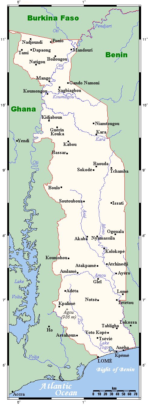
 Map of Togo
 Satellite image of Togo
Togo is a small Sub-Saharan nation comprising a long strip of land in West Africa. Togo's geographic coordinates are a latitude of 8° north and a longitude of 1°10′ east. It is bordered by three countries: Benin to the east, with 644 km (400 mi) of border; Burkina Faso to the north, with 126 km (78 mi) of border; and Ghana, with 877 km (545 mi) of border. To the south Togo has 56 km (35 mi) of coastline along the Bight of Benin of the Gulf of Guinea in the North Atlantic Ocean. Togo stretches 579 km (360 mi) north from the Gulf and is only 160 km (99 mi) wide at the broadest point. In total, Togo has an area of 56,785 km2 (21,925 sq mi), of which 54,385 km2 (20,998 sq mi) is land and 2,400 km2 (927 sq mi) is water.
The country consists primarily of two savanna plains regions separated by a southwest–northeast range of hills (the Chaîne du Togo).
Togo is commonly divided into six geographic regions. In the south are low-lying sandy beaches. The coastal region is narrow and followed by tidal flats and shallow lagoons. There are also a number of lakes, the largest of which is Lake Togo.
Further north lies the Ouatchi Plateau. This plateau is about 30 kilometres (19 mi) wide and located at an altitude of 60 to 90 metres (197 to 295 ft) above sea level. Terre de Barre is another name for this region, in use because of the reddish leached soil which is rich in iron. This southern area of Togo has been categorised by the World Wildlife Fund as part of the Guinean forest-savanna mosaic ecoregion.
Northeast of the Ouatchi Plateau lies a tableland. At its highest this region is about 500 metres (1,640 ft) above sea level. The area is drained by the Mono River and its tributaries, including the Ogou River.
To the west and the southwest of the tableland lie the Togo Mountains. These mountains run across the central region of Togo, ranging from the southwest to the northeast. The mountain range reaches into Benin where it is known as the Atakora Mountains and Ghana where it is known as the Akwapim Hills. The highest mountain in Togo is Mount Agou with a height of 986 metres (3,235 ft).
North of the Togo Mountains lies a sandstone plateau through which the Oti River flows. The vegetation is characterized by savanna. The River Oti which drains the plateau is one of the main tributaries of the River Volta.
In the far northwest of Togo lies a higher region which is characterized by its rocks: granite and gneiss. The cliffs of Dapaong (Dapango) are located in this part of Togo.
Contents
Land use
- Natural resources: phosphates, limestone, marble, arable land
- Land use:
- arable land: 32%
- permanent crops: 7%
- permanent pastures: 4%
- forests and woodland: 17%
- other: 34% (1993 est.)
- Natural hazards: hot, dry Harmattan wind can reduce visibility in north during winter; periodic droughts.
Climate
The climate is generally tropical with average temperatures ranging from 27.5 °C (81.5 °F) on the coast to about 30 °C (86 °F) in the northernmost regions, with a dry climate and characteristics of a tropical savanna. To the south there are two seasons of rain (the first between April and July and the second between (September and November), even though the average rainfall is not very high. The climate is tropical and humid for seven months while the dry desert winds of the harmatten blow south from November to March, bringing cooler weather.
Environment
Current issues:
- deforestation attributable to slash-and-burn agriculture and the use of wood for fuel
- recent droughts affecting agriculture
International agreements: Togo is party to: Biodiversity, Climate Change, Desertification, Endangered Species, Law of the Sea, Marine Dumping, Nuclear Test Ban, Ozone Layer Protection, Ship Pollution (MARPOL 73/78), Tropical Timber 83, Tropical Timber 94, Wetlands
Extreme points
This is a list of the extreme points of Togo, the points that are farther north, south, east or west than any other location.
- Northern-most point – the tripoint with Ghana and Burkina Faso, Savanes Region
- Eastern-most point – unnamed location on the border with Benin in the Mono river immediately west of the Beninese town of Grand-Popo, Maritime Region
- Southern-most point – the point at which the border with Ghana enters the Atlantic Ocean, Maritime Region
- Western-most point - the tripoint with Ghana and Burkina Faso, Savanes Region
Sovereign
states- Algeria
- Angola
- Benin
- Botswana
- Burkina Faso
- Burundi
- Cameroon
- Cape Verde
- Central African Republic
- Chad
- Comoros
- Democratic Republic of the Congo
- Republic of the Congo
- Côte d'Ivoire (Ivory Coast)
- Djibouti
- Egypt
- Equatorial Guinea
- Eritrea
- Ethiopia
- Gabon
- The Gambia
- Ghana
- Guinea
- Guinea-Bissau
- Kenya
- Lesotho
- Liberia
- Libya
- Madagascar
- Malawi
- Mali
- Mauritania
- Mauritius
- Morocco
- Mozambique
- Namibia
- Niger
- Nigeria
- Rwanda
- São Tomé and Príncipe
- Senegal
- Seychelles
- Sierra Leone
- Somalia
- South Africa
- South Sudan
- Sudan
- Swaziland
- Tanzania
- Togo
- Tunisia
- Uganda
- Zambia
- Zimbabwe
States with limited
recognition- Sahrawi Arab Democratic Republic
- Somaliland
Dependencies and
other territories- Canary Islands / Ceuta / Melilla / Plazas de soberanía (Spain)
- Madeira (Portugal)
- Mayotte / Réunion (France)
- Saint Helena / Ascension Island / Tristan da Cunha (United Kingdom)
- Western Sahara
Climate of Africa Sovereign
states- Algeria
- Angola
- Benin
- Botswana
- Burkina Faso
- Burundi
- Cameroon
- Cape Verde
- Central African Republic
- Chad
- Comoros
- Democratic Republic of the Congo
- Republic of the Congo
- Côte d'Ivoire (Ivory Coast)
- Djibouti
- Egypt
- Equatorial Guinea
- Eritrea
- Ethiopia
- Gabon
- The Gambia
- Ghana
- Guinea
- Guinea-Bissau
- Kenya
- Lesotho
- Liberia
- Libya
- Madagascar
- Malawi
- Mali
- Mauritania
- Mauritius
- Morocco
- Mozambique
- Namibia
- Niger
- Nigeria
- Rwanda
- São Tomé and Príncipe
- Senegal
- Seychelles
- Sierra Leone
- Somalia
- South Africa
- South Sudan
- Sudan
- Swaziland
- Tanzania
- Togo
- Tunisia
- Uganda
- Zambia
- Zimbabwe
States with limited
recognition- Sahrawi Arab Democratic Republic
- Somaliland
Dependencies and
other territories- Canary Islands / Ceuta / Melilla / Plazas de soberanía (Spain)
- Madeira (Portugal)
- Mayotte / Réunion (France)
- Saint Helena / Ascension Island / Tristan da Cunha (United Kingdom)
- Western Sahara
 Togo topics
History Politics Geography Economy and infrastructure Demographics and society Culture Languages · MusicCategories:

Wikimedia Foundation. 2010.