- Maryland Route 331
-
Maryland Route 331
Rhodesdale Vienna Road, East New Market Rhodesdale Road, Shiloh Church Hurlock Rd, Waddells Corner Road, East New Market Ellwood Road, Dover Bridge Road, Dover Road 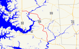
Route information Maintained by MDSHA Length: 28.74 mi[1][2][3] (46.25 km) Major junctions South end:  US 50 in Vienna
 MD 14 in Rhodesdale
 MD 392 in Hurlock
 MD 307 in Hurlock
 MD 16 near Hurlock
 MD 318 near Preston
MD 16 in Preston MD 578 in Bethlehem
North end: US 50 in EastonLocation Counties: Dorchester, Caroline, Talbot Highway system Maryland highway system
Interstate • US • State • Minor • Former • Turnpikes←  MD 330
MD 332  →
→Maryland Route 331 is a 28.74-mile (46.25 km) state highway on the Eastern Shore of Maryland in the United States. The route runs from Vienna in Dorchester County northwest to Easton in Talbot County, intersecting U.S. Route 50 at both ends. MD 331 is a two-lane undivided road most of its length that passes mostly through agricultural areas. The road also passes through the communities of Hurlock and Preston along the way. It encounters several routes during its journey, including Maryland Route 14 near Rhodesdale and Maryland Route 16 in the Preston area, both of which the route forms concurrencies with. In addition, the route also intersects with Maryland Route 392 and Maryland Route 307 in Hurlock and with Maryland Route 318 near Preston.
Most of present-day MD 331 was designated as part of U.S. Route 213 in 1926 when the U.S. Highway System was established. By 1940, US 213 was moved to a new alignment that crossed the Choptank River at Cambridge on a bridge built in 1935 and MD 331 was designated to run from Vienna to Easton. Both ends of MD 331 have been shortened since, with the southernmost portion of MD 331 curtailed following the completion of the US 50 bypass of Vienna by the 1990s and the northern terminus of the route cut back to US 50 in 2004 when the state-maintained portion of Dover Road to Dover Street in Easton was turned over to the city.
Contents
Route description
Dorchester County
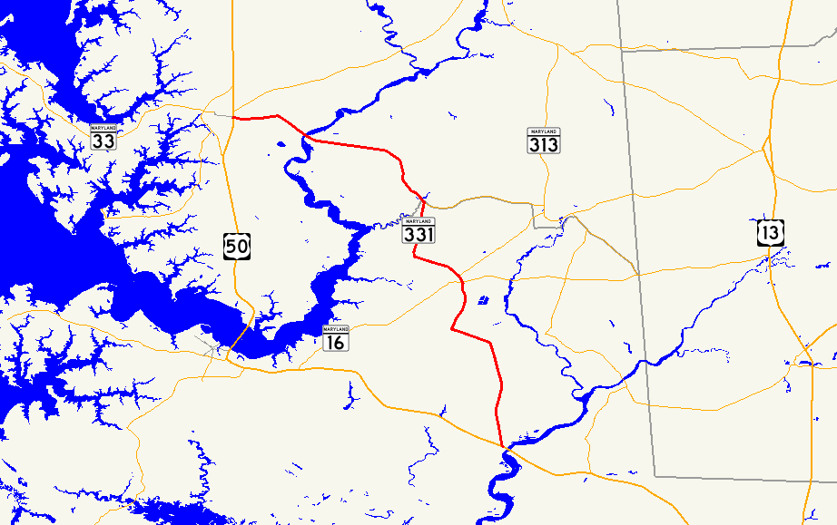
Maryland Route 331 begins at an interchange with U.S. Route 50 in Vienna, Dorchester County, a short distance west of the Nanticoke River. From this interchange, the route heads north on Rhodesdale Vienna Road, a two-lane undivided road with a 50 mph (80 km/h) speed limit.[1][4] It passes through wooded areas, with a set of power lines and an abandoned railroad line located along the east side of the road.[4] MD 331 continues into farmland, with some rural residences alongside the road, before it approaches Reids Grove, where Maryland Route 819 (Reids Grove Road) loops to the west of MD 331.[1][4] Past Reids Grove, the route continues through a mix of woodland and farmland, still paralleling the power lines and the abandoned railroad.[4] MD 331 reaches Rhodesdale, where it intersects Maryland Route 14 (Rhodesdale Eldorado Road). At this intersection, the route makes a left turn to run concurrent with MD 14 along East New Market Rhodesdale Road, heading west through Rhodesdale as a 30 mph (48 km/h) road. The road leaves Rhodesdale and heads into farmland as a 50 mph (80 km/h) road again. MD 331 splits from MD 14 by turning north on Shiloh Church Hurlock Road at an intersection.[1][4] Along Shiloh Church Hurlock Road, MD 331 passes a few residences before heading through more farm fields.[4]
Before the road enters Hurlock, the speed limit decreases to 40 mph (64 km/h).[1] In Hurlock, MD 331 heads into residential areas and the speed limit drops further to 30 mph (48 km/h) before the road crosses Jackson Street, where it becomes Main Street. It passes more residences before intersecting Maryland Route 392 (Delaware Avenue). Past MD 392, the speed limit lowers to 25 mph (40 km/h) as the road passes more homes before it heads into the downtown area of Hurlock, where it crosses a Maryland and Delaware Railroad line and Maryland Route 307 (Broad Street). Past this intersection, MD 331 heads northwest on Academy Street past numerous homes as the speed limit increases to 30 mph (48 km/h) and then to 40 mph (64 km/h) as the road leaves Hurlock. Upon leaving Hurlock, the road becomes Waddells Corner Road and the speed limit climbs to 50 mph (80 km/h) again as it heads into farmland.[1][4] The road turns to the west and continues through agricultural areas with intermittent residences.[4] It comes to an intersection with Maryland Route 16 (East New Market Ellwood Road), where MD 331 makes a right turn to head north along with MD 16.[1][4] MD 16 and MD 331 head north through a mix of woods and farms with some residences. The road continues through rural areas with an increasing number of residences as it approaches the Preston area. The road intersects the western terminus of Maryland Route 318 (Preston Road) near a car dealership. Past this intersection, MD 16 and MD 331 continue northwest on Preston Road.[1][4]
Caroline and Talbot counties
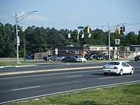 The northern terminus of MD 331 in Easton as viewed from eastbound US 50.
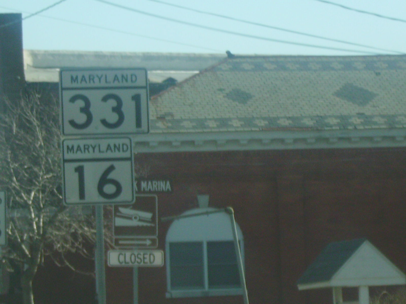
The road crosses the Hunting Creek into Caroline County. Before entering Preston, Maryland Route 817 loops off to the west of MD 16 and MD 331 on Linchester Road. Past MD 817, the road enters Preston, where it becomes Main Street, passing by residences and some businesses as a 25 mph (40 km/h) road. The route intersects Maryland Route 324 (Maple Avenue) before reaching the center of town, where MD 16 splits from MD 331 by heading northeast on Harmony Road. Past this intersection, the route passes more residences before leaving Preston, where it becomes 50 mph (80 km/h) Dover Bridge Road.[2][4] It heads north into rural areas of woods and farms with some residences along the road.[4] The road turns to the northwest and intersects Tanyard Road. MD 331 turns west and continues to the residential community of Bethlehem, where the speed limit decreases to 30 mph (48 km/h) and it intersects Maryland Route 578 (Bethlehem Road). Past Bethlehem, the road becomes a 50 mph (80 km/h) road again and continues past many rural residences.[2][4]
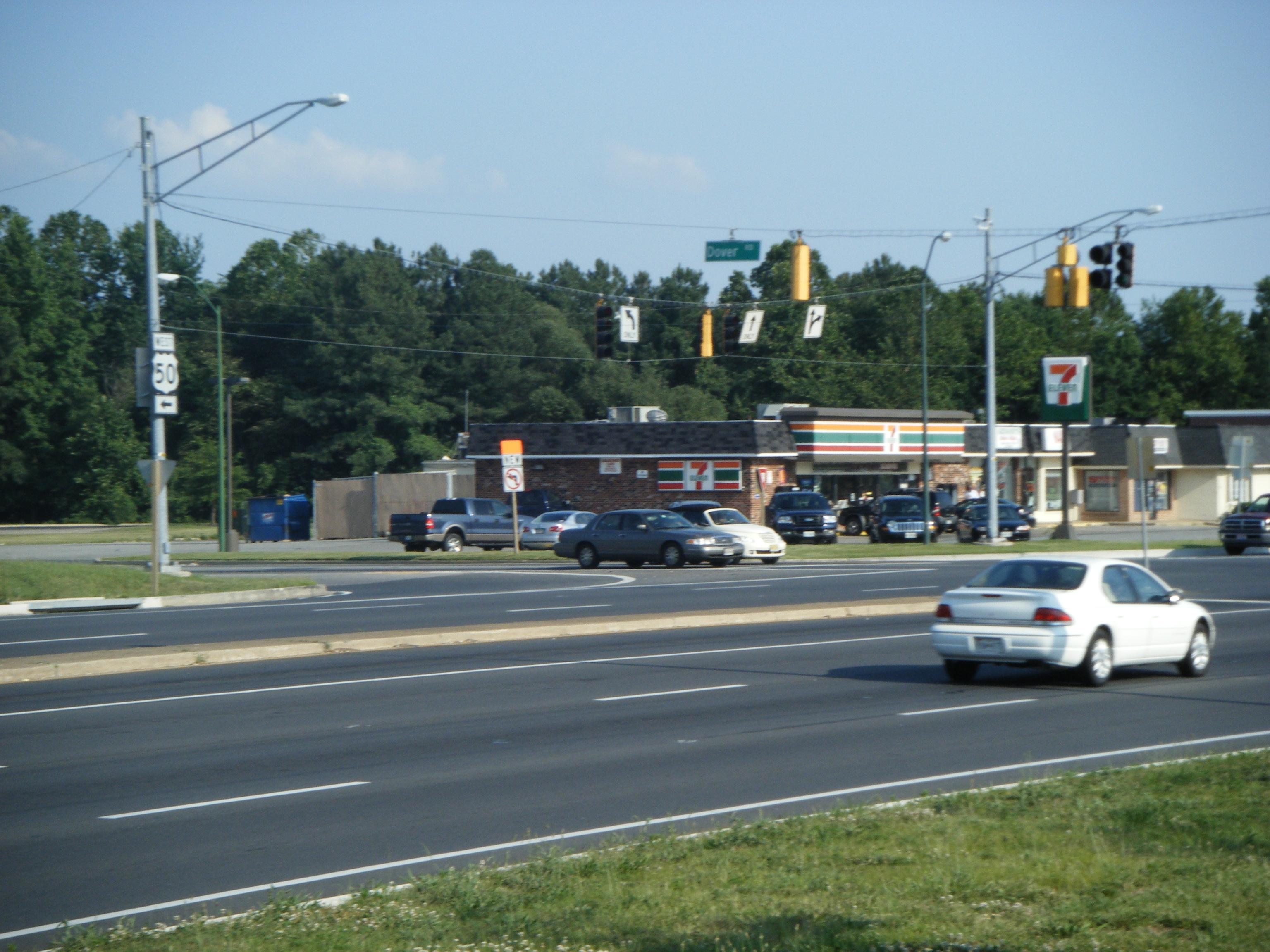
MD 331 enters wetlands as it approaches the Choptank River, which it crosses into Talbot County on the Dover Bridge, a swing bridge. Upon entering Talbot County, the route becomes Dover Road and continues to the northwest through a mix of woodland and farmland.[3][4] It turns to the west with the number of residences increasing as it approaches Easton.[4] Upon reaching Easton, the speed limit decreases to 40 mph (64 km/h) and then to 30 mph (48 km/h) as MD 331 heads into commercial and industrial areas. The route ends at the intersection with US 50 (Ocean Gateway), where Dover Road continues west as a local road toward downtown Easton.[3][4]
History
Original MD 331
MD 331 was originally assigned to the Easton–Trappe Road in southern Talbot County, one of the original state roads designated for improvement by the Maryland State Roads Commission in 1909.[5][6] The Easton–Trappe Road followed present-day MD 565 north from Trappe. At Peach Blossom Creek, the old highway is overlaid by US 50 and MD 322. The old alignment of MD 331 reappears as Washington Street in Easton, ending at Dover Street, where the main highway of the Eastern Shore that would later be designated US 213 turned north onto Washington Street.[7] MD 331 was paved from Easton in 1915 and reached Trappe by 1919.[8][9][10] The state highway was extended south to Cambridge when the first Choptank River Bridge opened in December 1935. On the Cambridge side of the bridge, a dual highway was constructed south to MD 16.[11][12]
Present MD 331
MD 331 from Rhodesdale to Easton was one of the original state roads marked for improvement in 1909. In 1910, the only paved sections of the highway were the approaches to Dover Bridge in both Talbot County and Caroline County.[6] The state road was paved from Hurlock to Shiloh Church in 1912, from Easton to Waddell's Corner in 1913 and 1914, from Waddell's Corner to Hurlock in 1915, and within Hurlock in 1916.[8][9] When the U.S. Highway System was organized in 1926, the state road became part of US 213.[13][7]
The first section of the Vienna–Rhodesdale highway was 2 miles (3.2 km) of pavement south from Rhodesdale that was completed by 1923.[14] The remainder of the highway was under construction by 1924, with another 2 miles (3.2 km) section of the road completed north from Vienna by 1927.[15][7] The gap between Vienna and Rhodesdale was filled in 1928.[16] When the Nanticoke River Bridge at Vienna was completed in 1931, US 213 was rerouted between Mardela Springs and Rhodesdale to pass through Vienna.[5][17] A new Dover Bridge, replacing a bridge built in the 19th century, was completed in 1932.[5][18][19] In 1939, the original MD 331 and US 213 swapped routes; US 213 also assumed MD 344 between Vienna and MD 16 at Mount Holly.[20]
MD 331 has seen little change since 1939. MD 331 and MD 16 were realigned around Ellwood and Linchester around 1960.[21][22] MD 331's southern terminus was truncated at its newly constructed interchange with US 50 in Vienna in 1991 shortly after US 50 bypassed Vienna.[23] MD 331's northern terminus has been rolled back twice in Easton. The state highway was rolled back from Washington Street to Park Street in 1983.[24] MD 331 was truncated at US 50 in 2004.[25]
Junction list
County Location Mile
[1][2][3]Roads intersected Notes Dorchester Vienna 0.00 US 50 (Ocean Gateway) – Cambridge, Salisbury, Ocean CityInterchange, southern terminus of MD 331 Reids Grove 2.73-2.90  MD 819 (Reids Grove Road)
Loop to west of MD 331 Rhodesdale 5.92  MD 14 east (Rhodesdale Eldorado Road) to MD 313 north – Eldorado
South end of MD 14 overlap 7.96 MD 14 west (East New Market Rhodesdale Road) – East New MarketNorth end of MD 14 overlap Hurlock 10.91 MD 392 (Delaware Avenue) to MD 30711.37 MD 307 north (Broad Street)13.82 MD 16 west (East New Market Ellwood Road) – East New MarketSouth end of MD 16 overlap 17.14 MD 318 east (Preston Road) – FederalsburgCaroline Preston 17.36-17.78  MD 817 (Linchester Road)
Loop to west of MD 16/MD 331 18.33  MD 324 south (Maple Avenue) – Choptank
18.40 MD 16 east (Harmony Road) – Harmony, DentonNorth end of MD 16 overlap Bethlehem 21.81 MD 578 north (Bethlehem Road) – Harmony24.78 Dover Bridge over Choptank River Talbot Easton 28.74 US 50 (Ocean Gateway)Northern terminus of MD 331 References
- ^ a b c d e f g h i "Highway Location Reference: Dorchester County" (PDF). Maryland State Highway Administration. 2009. http://sha.maryland.gov/Location/2009_DORCHESTER.pdf. Retrieved 2010-10-21.
- ^ a b c d "Highway Location Reference: Caroline County" (PDF). Maryland State Highway Administration. 2009. http://www.marylandroads.com/Location/2009_CAROLINE.pdf. Retrieved 2010-10-21.
- ^ a b c d "Highway Location Reference: Talbot County" (PDF). Maryland State Highway Administration. 2009. http://sha.maryland.gov/Location/2009_TALBOT.pdf. Retrieved 2010-10-21.
- ^ a b c d e f g h i j k l m n o p Google, Inc. Google Maps – overview of Maryland Route 331 (Map). Cartography by Google, Inc. http://maps.google.com/maps?f=d&source=s_d&saddr=US+50+and+MD+331+vienna,+md&daddr=38.646372,-75.892181+to:US+50+and+MD+331+easton,+md&geocode=&hl=en&mra=dpe&mrcr=0&mrsp=1&sz=11&via=1&sll=38.622235,-75.883942&sspn=0.237116,0.439453&ie=UTF8&ll=38.671573,-75.952606&spn=0.473905,0.878906&t=h&z=10. Retrieved 2009-04-29.
- ^ a b c Report of the State Roads Commission of Maryland. 1931-1934. Baltimore: Maryland State Roads Commission. 1934-12-28. pp. 19, 41, 46. http://www.archive.org/details/reportofstateroa1931mary. Retrieved 2010-10-05.
- ^ a b Maryland Geological Survey. Map of Maryland (Map) (1910 ed.).
- ^ a b c Maryland Geological Survey. Map of Maryland: Showing State Road System and State Aid Roads (Map) (1927 ed.).
- ^ a b Report of the State Roads Commission of Maryland. 1912-1915. Baltimore: Maryland State Roads Commission. May 1915. pp. 108, 110, 114, 124, 126. http://www.archive.org/details/annualreportsofs1912mary. Retrieved 2010-10-05.
- ^ a b Report of the State Roads Commission of Maryland. 1916-1919. Baltimore: Maryland State Roads Commission. January 1920. pp. 48, 52. http://www.archive.org/details/annualreportsofs1916mary. Retrieved 2010-10-05.
- ^ Maryland Geological Survey. Map of Maryland: Showing State Road System and State Aid Roads (Map) (1921 ed.).
- ^ Report of the State Roads Commission of Maryland. 1935-1936. Baltimore: Maryland State Roads Commission. 1936-12-04. pp. 61, 68. http://www.archive.org/details/reportofstateroa1935mary. Retrieved 2010-10-05.
- ^ Maryland State Roads Commission. Map of Maryland Showing State Road System (Map) (1936 ed.).
- ^ Bureau of Public Roads (1926). United States System of Highways (Map). http://en.wikipedia.org/wiki/Image:1926us.jpg. Retrieved 2010-10-05.
- ^ Maryland Geological Survey. Map of Maryland: Showing State Road System and State Aid Roads (Map) (1923 ed.).
- ^ Report of the State Roads Commission of Maryland. 1924-1926. Baltimore: Maryland State Roads Commission. January 1927. pp. 25–26, 100. http://www.archive.org/details/annualreportsofs1924mary. Retrieved 2010-10-05.
- ^ Maryland Geological Survey. Map of Maryland: Showing State Road System and State Aid Roads (Map) (1928 ed.).
- ^ Maryland Geological Survey. Map of Maryland Showing State Road System: State Aid Roads and Improved County Road Connections (Map) (1933 ed.).
- ^ "NBI Structure Number: 100000200023010". National Bridge Inventory. http://nationalbridges.com/nbi_record.php?StateCode=24&struct=100000200023010. Retrieved 2010-10-05.
- ^ "Dover Bridges". Choptank River Heritage Center. http://www.riverheritage.org/Riverguide/sites/html/dover_bridges.html. Retrieved 2009-05-01.
- ^ Maryland State Roads Commission. General Highway Map: State of Maryland (Map) (1939 ed.).
- ^ "NBI Structure Number: 100000050014020". National Bridge Inventory. http://nationalbridges.com/nbi_record.php?StateCode=24&struct=100000050014020. Retrieved 2010-10-05.
- ^ Maryland State Roads Commission. Maryland: Official Highway Map (Map) (1960 ed.).
- ^ Maryland State Highway Administration. Maryland: Official Highway Map (Map) (1991 ed.).
- ^ Maryland State Highway Administration. Maryland: Official Highway Map (Map) (1983-84 ed.).
- ^ "Highway Location Reference: Talbot County" (PDF). Maryland State Highway Administration. 2004. http://www.marylandroads.com/Location/2004_TALBOT.pdf. Retrieved 2010-10-05.
External links
Roads in Caroline County, Maryland State highways 
Roads in Dorchester County, Maryland State highways 
U.S. Highways Roads in Talbot County, Maryland State highways 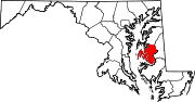
U.S. Highways Categories:- State highways in Maryland
- Roads in Caroline County, Maryland
- Roads in Dorchester County, Maryland
- Roads in Talbot County, Maryland


Wikimedia Foundation. 2010.