- Maryland Route 662
-
Maryland Route 662
Sections of MD 662 highlighted in red, from south to north: MD 662C, MD 662B, and MD 662Route information Maintained by MDSHA MD 662C Length: 6.10 mi[1] (9.82 km) South end: Dead end in Easton North end:  US 50 in Longwoods
MD 662B Length: 2.16 mi[1] (3.48 km) South end: US 50 in LongwoodsNorth end: US 50 in SkiptonMD 662 Length: 4.43 mi[1][2] (7.13 km) South end: US 50 near SkiptonMajor
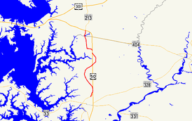
junctions: MD 213 in Wye Mills
North end: US 50 near Wye MillsLocation Counties: Talbot, Queen Anne's Highway system Maryland highway system
Interstate • US • State • Minor • Former • Turnpikes←  MD 661
MD 663  →
→Maryland Route 662 (MD 662) is a collection of state highways in the U.S. state of Maryland. These highways are sections of old alignment of U.S. Route 50 (US 50) between Easton and Wye Mills in Talbot County and Queen Anne's County. MD 662C runs from Easton to Longwoods. MD 662B runs from Longwoods to Skipton. MD 662 runs from Skipton to Wye Mills. MD 662A is an unsigned ramp at the northern end of MD 662. MD 662D is an unsigned connector along MD 662C. The three main sections of MD 662 were designated in 1948 following the construction of US 50's bypasses of Easton and Wye Mills. MD 662C was extended south in Easton in the late 1990s.
Contents
Route description
MD 662C and MD 662B
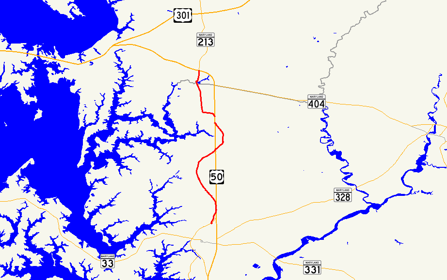
MD 662C is the designation for Centreville Road and Longwoods Road, a 6.10-mile (9.82 km) section of the old alignment of US 50 on the eastbound side of the federal highway between Easton and Longwoods. The state highway begins as Centreville Road at a dead end in an industrial area adjacent to Easton Airport. MD 662C immediately intersects Airpark Drive (unsigned MD 322B), which is used to access MD 322 (Easton Parkway) and Washington Street, the main north–south street through the center of Easton.[1][3] The state highway continues north between US 50 on the east and the airport on the west. At the northeast corner of the airport property, MD 662C intersects Airport Road, which provides access to the airport to the west and US 50 and MD 309 to the east.[3] The state highway's name changes to Longwoods Road.[1] After passing a 0.04 miles (0.064 km) connector to US 50, unsigned MD 662D, the highway veers away from US 50 through farmland, passing All Saints' Church.[4][1][3] MD 662C crosses Potts Mill Creek before passing through the hamlet of Longwoods.[1][3] After passing Probasco Landing Road, the state highway reaches its northern terminus at US 50 opposite the southern terminus of MD 662B.[1]
MD 662B is the designation for Old Skipton Road, a 2.16 mi (3.48 km) section of the old alignment of US 50 on the westbound side of the federal highway between Longwoods and Skipton. The state highway begins at US 50 opposite the northern terminus of MD 662C. MD 662C heads northeast and passes between residences on large lots before entering a forested area and crossing Skipton Creek. The highway veers north and then northwest, crossing another creek and passing through the hamlet of Skipton before reaching its northern terminus at US 50.[1][5]
MD 662
MD 662 is the designation for Old Wye Mills Road and Wye Mills Road, a 4.43 mi (7.13 km) section of the old alignment of US 50 on the eastbound side of the federal highway between Skipton and Wye Mills. The state highway begins at US 50 as Old Wye Mills Road a short distance north of the northern terminus of MD 662B. MD 662 heads north and west, crossing Mill Creek, before turning north through a mix of residences and farmland.[1][6] The state highway enters the unincorporated village of Wye Mills, where it passes Old Wye Church and Wye Oak State Park, which contains the remains of the Wye Oak. MD 662 meets the west end of MD 404 (Queen Annes Highway) before crossing the Wye East River, a tributary of the Wye River, and entering Queen Anne's County.[6] MD 213 (College Drive) splits to the north as MD 662, now named Wye Mills Road, veers to the northwest.[2][6] MD 662 passes Chesapeake College before reaching its northern terminus at US 50.[6] The ramp from eastbound US 50 to southbound MD 662 is unsigned MD 662A, which is 0.08 mi (0.13 km) in length.[2][7]
History
The three mainline sections of MD 662 comprise the original alignment of US 213 from Easton to Wye Mills and of MD 404 north of Wye Mills.[8] MD 662 was assigned in 1948 to those segments when Easton and Wye Mills were bypassed with a straighter highway that in 1949 became part of an extended US 50.[9][10] MD 662C's southern terminus was originally north of Airport Road where it merged with US 50.[11] MD 662C was extended south parallel to US 50 by 1999.[12] MD 662A has existed since at least 1999, while MD 662D was assigned in 2009.[13][1]
Junction list
MD 662C and MD 662B
MD 662C and MD 662B are entirely in Talbot County.
Location Mile
[1]Destinations Notes Easton 0.00 Dead end Southern terminus of MD 662C 0.02 Airpark Drive to  MD 322 (Easton Parkway) to US 50 / Washington Street
Airpark Drive east is unsigned MD 322B 1.30 Airport Road to  MD 309 (Black Dog Alley) / US 50
Longwoods 6.10 US 50 (Ocean Gateway) – Easton, Bay BridgeNorthern terminus of MD 662C; southern terminus of MD 662B 0.00 Skipton 2.16 US 50 (Ocean Gateway) – Easton, Bay BridgeNorthern terminus of MD 662B MD 662
County Location Mile
[2][1]Destinations Notes Talbot Skipton 0.00 US 50 (Ocean Gateway) – Easton, Bay BridgeSouthern terminus of MD 662 Wye Mills 2.98  MD 404 east (Queen Annes Highway) – Queen Anne, Denton
Queen Anne's 3.11 MD 213 north (College Drive) – Centreville4.43 US 50 (Ocean Gateway) – Easton, Bay BridgeNorthern terminus of MD 662 References
- ^ a b c d e f g h i j k l m "Highway Location Reference: Talbot County" (PDF). Maryland State Highway Administration. 2009. http://www.marylandroads.com/Location/2009_TALBOT.pdf. Retrieved 2010-10-05.
- ^ a b c d "Highway Location Reference: Queen Anne's County" (PDF). Maryland State Highway Administration. 2009. http://www.marylandroads.com/Location/2009_QUEENANNES.pdf. Retrieved 2010-10-05.
- ^ a b c d Google, Inc. Google Maps – Maryland Route 662C (Map). Cartography by Google, Inc. http://maps.google.com/maps?f=d&source=s_d&saddr=Centreville+Rd&daddr=longwoods,+md+to:MD-662+N%2FOld+Skipton+Rd&hl=en&geocode=FeT2TwIdSFR3-w%3BFUjtUAIdwR93-ynJgWeFKWu4iTFI0jYdxfIhAA%3BFfwjUQIdlmV3-w&mra=ls&sll=38.871556,-76.060753&sspn=0.015269,0.038581&ie=UTF8&t=h&z=12. Retrieved 2010-06-09.
- ^ Google, Inc. Google Maps – Maryland Route 662D (Map). Cartography by Google, Inc. http://maps.google.com/maps?f=d&source=s_d&saddr=Unknown+road&daddr=Unknown+road&geocode=FTRHUAIdbGd3-w%3BFVJHUAIdfGp3-w&hl=en&mra=ls&sll=38.815494,-76.059283&sspn=0.003837,0.009645&ie=UTF8&t=h&z=20. Retrieved 2010-10-05.
- ^ Google, Inc. Google Maps – Maryland Route 662B (Map). Cartography by Google, Inc. http://maps.google.com/maps?f=d&source=s_d&saddr=MD-662+N%2FOld+Skipton+Rd&daddr=MD-662+N%2FOld+Wye+Mills+Easton+Rd+to:MD-662+N%2FOld+Skipton+Rd&hl=en&geocode=FQYkUQIdhmZ3-w%3BFU9mUQId8IF3-w%3BFRCNUQIdVmR3-w&mra=ls&sll=38.885515,-76.05782&sspn=0.030533,0.077162&ie=UTF8&ll=38.885488,-76.057491&spn=0.030533,0.077162&t=h&z=14. Retrieved 2010-06-09.
- ^ a b c d Google, Inc. Google Maps – Maryland Route 662 (Map). Cartography by Google, Inc. http://maps.google.com/maps?f=d&source=s_d&saddr=MD-662+S%2FOld+Wye+Mills+Rd&daddr=MD-662+S%2FOld+Wye+Mills+Rd+to:MD-662+S%2FWye+Mills+Rd&hl=en&geocode=FZanUQIdAmN3-w%3BFQMNUgId2Cd3-w%3BFQZ3UgIdcOh2-w&mra=ls&sll=38.957106,-76.083755&sspn=0.015251,0.038581&ie=UTF8&t=h&z=13. Retrieved 2010-06-09.
- ^ Google, Inc. Google Maps – Maryland Route 662A (Map). Cartography by Google, Inc. http://maps.google.com/maps?f=d&source=s_d&saddr=Unknown+road&daddr=Unknown+road&hl=en&geocode=FSV5UgIdh-R2-w%3BFQB2UgIdNeh2-w&mra=ls&sll=38.958841,-76.092371&sspn=0.003813,0.009645&ie=UTF8&t=h&z=19. Retrieved 2010-06-09.
- ^ Maryland State Roads Commission. Maryland: Official Highway Map (Map) (1946-47 ed.).
- ^ Maryland State Roads Commission. Maryland: Official Highway Map (Map) (1948 ed.).
- ^ Maryland State Roads Commission. Maryland: Official Highway Map (Map) (1949 ed.).
- ^ Maryland State Highway Administration. Maryland: Official Highway Map (Map) (1997 ed.).
- ^ Maryland State Highway Administration. Maryland: Official Highway Map (Map) (1999-2000 ed.).
- ^ "Highway Location Reference: Talbot County" (PDF). Maryland State Highway Administration. 1999. http://www.marylandroads.com/Location/1999_TALBOT.pdf. Retrieved 2010-10-05.
External links
Roads in Queen Anne's County, Maryland State highways 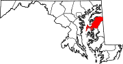
U.S. Highways Roads in Talbot County, Maryland State highways 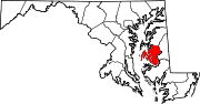
U.S. Highways Categories:- State highways in Maryland
- Roads in Queen Anne's County, Maryland
- Roads in Talbot County, Maryland


Wikimedia Foundation. 2010.