- Maryland Route 302
-
Maryland Route 302
Route information Maintained by MDSHA Length: 10.21 mi[1][2] (16.43 km) Major junctions West end:  US 301 west of Barclay
 MD 454 in Templeville
East end:  DE 11 east of Templeville
Location Counties: Queen Anne's, Caroline Highway system Maryland highway system
Interstate • US • State • Minor • Former • Turnpikes←  MD 301
MD 303  →
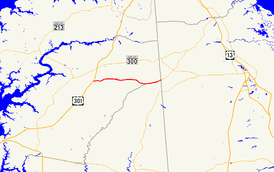
→Maryland Route 302 (MD 302) is a state highway in the U.S. state of Maryland. Known for most of its length as Barclay Road, the state highway runs 10.21 miles (16.43 km) from U.S. Route 301 (US 301) west of Barclay east to the Delaware state line east of Templeville, where the highway continues east as Delaware Route 11 (DE 11). MD 302 follows the Queen Anne's–Caroline county line for part of its length near Templeville. The county line road is considered to be in Caroline County for maintenance purposes.[3] MD 302 was first paved in Barclay in the early 1920s and from Templeville to the state line in the late 1920s. The gap between Barclay and Templeville was filled in the late 1930s. MD 302 was extended west toward Church Hill in the late 1940s and to US 301 in the mid 1960s.
Contents
Route description
MD 302 begins at an intersection with US 301 (Blue Star Memorial Highway) about midway between Church Hill and Barclay. Hall Road continues west as a county highway toward Church Hill. MD 302 heads east as two-lane Barclay Road through farmland. The state highway crosses Red Lion Branch just before entering the town of Barclay, where the highway's name changes to Church Street. MD 302 crosses the Centreville Branch of the Northern Line of the Maryland and Delaware Railroad and intersects MD 313 (Goldsboro Road). The state highway becomes Barclay Road again upon leaving the town limits and passes through a mix of farmland and forest.[1][4] The state highway runs atop the Queen Anne's–Caroline county line starting just before the intersection with Woodyard Road. MD 302 passes through the town of Templeville, where the highway intersects MD 454 (Crown Stone Road). East of the town, shortly after crossing Beaver Dam Ditch, MD 302 reaches its eastern terminus at the Delaware state line. The highway continues east as DE 11 (Arthursville Road) toward Hartly.[2][4]
History
The first section of MD 302 was about 1 mile (1.6 km) east from MD 313 in Barclay paved in 1923.[5] A second, unconnected section was completed between Templeville and the Delaware state line in 1930.[6][7] The gap between Barclay and Templeville was filled in 1939.[8][9] MD 302 was extended west about 2 miles (3.2 km) toward Church Hill in 1949.[10][11] The state highway reached its present length when it was extended to US 301 in 1966.[12]
Junction list
MD 302 follows the Queen Anne's–Caroline county line from just west of Woodyard Road near Templeville and the Delaware state line. The county line portion is considered to be in Caroline County for maintenance purposes.[3]
County Location Mile
[1][2]Intersection Notes Queen Anne's 0.00 Hall Road west – Church Hill Western terminus US 301 (Blue Star Memorial Highway) – Bay Bridge, WilmingtonBarclay 3.48  MD 313 (Goldsboro Road) – Sudlersville, Goldsboro
Caroline Templeville 9.10 MD 454 south (Crown Stone Road) – Marydel, Dover10.21 DE 11 north (Arthursville Road) – Hartly, DEEastern terminus; Delaware state line 1.000 mi = 1.609 km; 1.000 km = 0.621 mi References
- ^ a b c "Highway Location Reference: Queen Anne's County" (PDF). Maryland State Highway Administration. 2009. http://www.marylandroads.com/Location/2009_QUEENANNES.pdf. Retrieved 2010-09-28.
- ^ a b c "Highway Location Reference: Caroline County" (PDF). Maryland State Highway Administration. 2009. http://www.marylandroads.com/Location/2009_CAROLINE.pdf. Retrieved 2010-09-28.
- ^ a b "Roads Maintained by District 2 - Caroline County". Maryland State Highway Administration. http://www.sha.maryland.gov/Index.aspx?PageId=479. Retrieved 2010-09-28.
- ^ a b Google, Inc. Google Maps – Maryland Route 302 (Map). Cartography by Google, Inc. http://maps.google.com/maps?f=d&source=s_d&saddr=MD-302+E%2FBarclay+Rd&daddr=MD-302+E%2FBarclay+Rd&geocode=Faw9VQIdZHd5-w%3BFZhHVQIdeC58-w&hl=en&mra=ls&sll=39.141628,-75.747793&sspn=0.007639,0.01929&ie=UTF8&t=h&z=12. Retrieved 2010-09-28.
- ^ Maryland Geological Survey. Map of Maryland: Showing State Road System and State Aid Roads (Map) (1923 ed.).
- ^ Report of the State Roads Commission of Maryland. 1927-1930. Baltimore: Maryland State Roads Commission. 1930-10-01. pp. 224–225. http://www.archive.org/details/reportofstateroa1927mary. Retrieved 2010-09-28.
- ^ Maryland Geological Survey. Map of Maryland Showing State Road System: State Aid Roads and Improved County Road Connections (Map) (1930 ed.).
- ^ Maryland State Roads Commission. General Highway Map: State of Maryland (Map) (1939 ed.).
- ^ Report of the State Roads Commission of Maryland. 1939-1940. Baltimore: Maryland State Roads Commission. 1941-03-15. p. 91. http://www.archive.org/details/reportofstateroa1939mary. Retrieved 2010-09-28.
- ^ Report of the State Roads Commission of Maryland. 1947-1948. Baltimore: Maryland State Roads Commission. 1949-02-15. p. 106. http://www.archive.org/details/reportofstateroa1947mary. Retrieved 2010-09-28.
- ^ Maryland State Roads Commission. Maryland: Official Highway Map (Map) (1949 ed.).
- ^ Maryland State Roads Commission. Maryland: Official Highway Map (Map) (1966 ed.).
External links
Roads in Caroline County, Maryland State highways 
Roads in Queen Anne's County, Maryland State highways 
U.S. Highways Categories:- State highways in Maryland
- Roads in Queen Anne's County, Maryland
- Roads in Caroline County, Maryland


Wikimedia Foundation. 2010.