- Maryland Route 480
-
Maryland Route 480
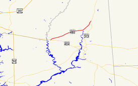
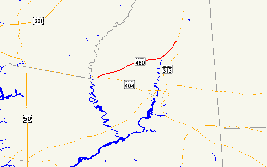
Maryland Route 480 highlighted in redRoute information Maintained by MDSHA Length: 9.08 mi[1] (14.61 km) Major junctions West end:  MD 404 in Hillsboro
 MD 314 in Greensboro
East end:  MD 313 in Greensboro
Location Counties: Caroline Highway system Maryland highway system
Interstate • US • State • Minor • Former • Turnpikes←  MD 478
MD 481  →
→Maryland Route 480 (MD 480) is a state highway in the U.S. state of Maryland. Known for most of its length as Ridgely Road, the state highway runs 9.08 miles (14.61 km) from MD 404 in Hillsboro east to MD 313 in Greensboro. MD 480 passes through Ridgely, where it has a concurrency with MD 312. The state highway was constructed between Ridgely and Greensboro in the early 1930s. MD 480 was rerouted in both towns in the early 1950s before being extended west to Hillsboro in the late 1950s.
Contents
Route description
MD 480 begins at an intersection with MD 404 in Hillsboro. Ridgely Road continues south toward the center of Hillsboro. MD 480 heads northeast through farmland until it meets MD 312 (Downes Station Road) on the outskirts of Ridgely.[2] The two state highways continue northeast, with MD 776 (Sunset Boulevard) splitting to the north immediately before the road enters the town limits of Ridgely, where its name temporarily changes to Sixth Street and the highway passes Martin Sutton Memorial Park.[1][2] The concurrency of MD 480 and MD 312 ends where the latter highway heads north into the center of town on Central Avenue. MD 480 heads east out of town, continuing straight through farmland.[2] After traversing Forge Branch, the state highway veers to the northeast, paralleling the Choptank River at a distance until the highway enters Greensboro, where its name changes again to Main Street.[1][2] MD 480 intersects MD 314 (Sunset Avenue) in the center of the town. The state highway traverses an S-curve and passes Greensboro Elementary School before reaching its northern terminus at MD 313 (Greensboro Road).[1][2]
History
MD 480 was under construction from Ridgely to Greensboro by 1932 and completed in 1933.[3][4][5] The state highway originally followed Central Avenue in Ridgely south from MD 312, then turned east onto Sixth Street toward Greensboro. In Greensboro, MD 480 had its eastern terminus at present-day MD 314. MD 480 north to its present eastern terminus and MD 314 east across the Choptank River were originally part of MD 313.[6] When MD 313 bypassed Greensboro in 1950, MD 480 was extended north through Greensboro to its present terminus.[7] When the Ridgely Cutoff was completed in 1953, MD 312 replaced MD 480 on Central Avenue.[8][9] MD 480's western terminus was the intersection of Central Avenue and Sixth Street until MD 480 was extended west to MD 404 in Hillsboro in 1959.[10]
Junction list
The entire route is in Caroline County.
Location Mile
[1]Destinations Notes Hillsboro 0.00 Ridgely Road south Western terminus MD 404 (Shore Highway) – Denton, Bay BridgeRidgely 2.50  MD 312 south (Downes Station Road) – Denton
West end of concurrency with MD 312 2.90  MD 776 north (Sunset Boulevard)
3.38 MD 312 north (Central Avenue) / Central Avenue southEast end of concurrency with MD 312 Greensboro 8.21 MD 314 (Sunset Avenue) – Whiteleysburg9.08 MD 313 (Greensboro Road) – GoldsboroEastern terminus 1.000 mi = 1.609 km; 1.000 km = 0.621 mi References
- ^ a b c d e "Highway Location Reference: Caroline County" (PDF). Maryland State Highway Administration. 2009. http://www.marylandroads.com/Location/2009_CAROLINE.pdf. Retrieved 2010-09-03.
- ^ a b c d e Google, Inc. Google Maps – Maryland Route 480 (Map). Cartography by Google, Inc. http://maps.google.com/maps?f=d&source=s_d&saddr=MD-480+E%2FRidgely+Rd&daddr=N+Main+St%2FMD-480+E&geocode=FcbgUQIduk55-w%3BFdjcUgIdQmV7-w&hl=en&mra=ls&sll=38.979395,-75.803604&sspn=0.015246,0.038581&ie=UTF8&t=h&z=12. Retrieved 2010-05-17.
- ^ "NBI Structure Number: 100000050019010". National Bridge Inventory. http://nationalbridges.com/nbi_record.php?StateCode=24&struct=100000050019010. Retrieved 2010-09-03.
- ^ Report of the State Roads Commission of Maryland. 1931-1934. Baltimore: Maryland State Roads Commission. 1934-12-28. p. 324. http://www.archive.org/details/reportofstateroa1931mary. Retrieved 2010-09-03.
- ^ Maryland Geological Survey. Map of Maryland Showing State Road System: State Aid Roads and Improved County Road Connections (Map) (1933 ed.).
- ^ Maryland State Roads Commission. General Highway Map: State of Maryland (Map) (1939 ed.).
- ^ Report of the State Roads Commission of Maryland. 1949-1950. Baltimore: Maryland State Roads Commission. 1950-12-20. p. 110. http://www.archive.org/details/reportofstateroa1949mary. Retrieved 2010-09-03.
- ^ Report of the State Roads Commission of Maryland. 1953-1954. Baltimore: Maryland State Roads Commission. 1954-11-12. p. 153. http://www.archive.org/details/reportofstateroa1953mary. Retrieved 2010-09-03.
- ^ Maryland State Roads Commission. Maryland: Official Highway Map (Map) (1953 ed.).
- ^ Maryland State Roads Commission. Maryland: Official Highway Map (Map) (1959 ed.).
External links
Roads in Caroline County, Maryland State highways 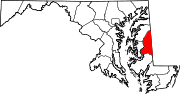 Categories:
- State highways in Maryland
- Roads in Caroline County, Maryland


Wikimedia Foundation. 2010.