- Mylor Bridge
-
Coordinates: 50°11′09″N 5°04′39″W / 50.18592°N 5.07757°W
Mylor Bridge Cornish: Ponsnowydh 
 Mylor Bridge
Mylor Bridge shown within CornwallOS grid reference SW804363 Parish Mylor Unitary authority Cornwall Ceremonial county Cornwall Region South West Country England Sovereign state United Kingdom Post town FALMOUTH Postcode district TR11 Dialling code 01326 Police Devon and Cornwall Fire Cornwall Ambulance South Western EU Parliament South West England UK Parliament Truro and Falmouth List of places: UK • England • Cornwall Mylor Bridge (Cornish: Ponsnowydh) is a village in Cornwall, United Kingdom. It is situated in Mylor civil parish at the head of Mylor Creek approximately five miles north of Falmouth.[1]
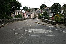
Mylor Bridge has a post office, newsagent, grocery store, fishmonger, butcher's shop and a pub called the Lemon Arms. The village also has a dental surgery and a primary school[2]. The parish church of Saint Mylor is in the nearby village of Mylor Churchtown.[3]
Governance
The village is represented as Penryn East and Mylor on Cornwall Council.[4] It was formerly in the Falmouth and Camborne parliamentary electoral constituency; from 2010 it will be in the Falmouth and Truro constituency.[5][6]
References
- ^ Ordnance Survey: Landranger map sheet 204 Truro & Falmouth ISBN 9780319231494
- ^ Mylor Bridge Primary School; Retrieved April 2010
- ^ GENUKI website; Mylor. Retrieved April 2010
- ^ Cornwall Council website. Retrieved April 2010
- ^ Politics.co.uk website; Retrieved April 2010
- ^ BBC website; Election constituencies; Truro and falmouth. Retrieved April 2001
 Mylor Bridge
Geography of Cornwall Cornwall Portal Unitary authorities Major settlements Bodmin • Bude • Callington • Camborne • Camelford • Falmouth • Fowey • Hayle • Helston • Launceston • Liskeard • Looe • Lostwithiel • Marazion • Newlyn • Newquay • Padstow • Par • Penryn • Penzance • Porthleven • Redruth • Saltash • St Austell • St Blazey • St Columb Major • St Ives • St Just-in-Penwith • St Mawes • Stratton • Torpoint • Truro • Wadebridge
See also: Civil parishes in CornwallRivers Topics History • Status debate • Flag • Culture • Places • People • The Duchy • Diocese • Politics • Hundreds/shires • Places of interest • full list...Categories:- Cornwall geography stubs
- Villages in Cornwall


Wikimedia Foundation. 2010.