- Newquay
-
For other uses, see New Quay (disambiguation).
Coordinates: 50°24′43″N 5°04′33″W / 50.4120°N 5.0757°W
Newquay Cornish: Tewyn Plustry 
Looking towards Newquay Harbour
 Newquay
Newquay shown within CornwallPopulation 19,562 (Civil Parish, 2001) OS grid reference SW815615 Parish Newquay Unitary authority Cornwall Ceremonial county Cornwall Region South West Country England Sovereign state United Kingdom Post town NEWQUAY Postcode district TR7 Dialling code 01637 Police Devon and Cornwall Fire Cornwall Ambulance South Western EU Parliament South West England UK Parliament St Austell and Newquay List of places: UK • England • Cornwall Newquay (Cornish: Tewyn Plustry/Towan Blystra) is a town, civil parish, seaside resort and fishing port in Cornwall, England. It is situated on the North Atlantic coast of Cornwall approximately 20 miles (32 km) west of Bodmin and 12 miles (19 km) north of Truro.[1]
The town is bounded to the west by the River Gannel and its associated salt marsh, and to the east by the Porth Valley. Newquay has been expanding inland (south) since it was founded.
In 2001, the census recorded a permanent population of 19,562.[2]
Contents
History
Prehistoric period
There are some pre-historic burial mounds and an embankment on the area now known as The Barrowfields, 400 m (1,300 ft) from Trevelgue. There were once up to fifteen barrows, but now only a few remain. Excavations here have revealed charred cooking pots and a coarse pottery burial urn containing remains of a Bronze Age chieftain, who was buried here up to 3,500 years ago.[3]
In 1987, evidence of a Bronze Age village was found at Trethellan Farm, a site that overlooks the River Gannel.[4]
The first signs of settlement in the Newquay area consist of a late Iron Age hill fort/industrial centre which exploited the nearby abundant resources (including deposits of iron) and the superior natural defences provided by Trevelgue Head. It is claimed that occupation of the site was continuous from the 3rd century BC to the 5th or 6th century AD (a Dark Ages house was later built on the head).[5]
Medieval period
The curve of the headland around what is now Newquay Harbour provided natural protection from bad weather and a small fishing village grew up in the area. When the village was first occupied is unknown but it is not mentioned in the Domesday Book although a local house (now a bar known as "Treninnick Tavern") is included.[6] By the 15th century, the village was called "Towan Blystra"—-"Towan" means sand hill/dune in Cornish, "Blystra" meaning blown-—but the anchorage was exposed to winds from the north east and in 1439 the local burgesses applied to Edmund Lacey, Bishop of Exeter for leave and funds to build a "New quay" from which the town derives its current name.
Modern period
 Newquay Harbour in 1904
 Newquay Harbour today
The first national British census of 1801 recorded around 1,300 inhabitants in the settlement (enumerated as a village under St Columb Minor parish). The construction of the current harbour started in 1832.[7] Newquay parish was created in 1882.[8]
A mansion called the Tower was built for the Molesworth family in 1835: it included a castellated tower and a private chapel as they were devout Roman Catholics. The Tower later became the golf club house.[9] After the arrival of passenger trains in 1876, the former fishing village started to grow. Several major hotels were built around the turn of the 19th century, including the Victoria in East Street, the Atlantic and the Headland. The three churches were also built soon after 1901.
Growth of the town eastwards soon reached the area around the railway station: Station Road became Cliff Road around 1930, and the houses beyond, along Narrowcliff, were also converted into hotels. Narrowcliff was first known as Narrowcliff Promenade, and then Narrowcliff Road. On some pre-war maps it is spelt Narrowcliffe.
At the time of the First World War the last house at the edge of the town was a little further along present-day Narrowcliff, and in more recent times this building became the Garth Hotel. Post-war development saw new houses and streets built in the Chester Road area, accompanied by ribbon development along the country lane which led to St Columb Minor, some 2 miles (3 km) away. This thoroughfare was modernised and named Henver Road, also some time in the 1930s. Development continued in this direction until the Second World War, by which time much of Henver Road had houses on both sides, with considerably infilling also taking place between there and the sea.
It was not until the early 1950s that the last houses were built along Henver Road itself: after that, there was a virtually continuous building line on both sides of the main road from the other side of St Columb Minor right into the town centre. The Doublestiles estate to the north of Henver Road was also built in the early 1950s, as the name of Coronation Way indicates, and further development continued beyond, becoming the Lewarne Estate and extending the built up area to the edges of Porth.
Other areas also developed in the period between the wars were Pentire (known for a time as West Newquay) and the Trenance Valley. Other streets dating from the 1920s included St Thomas Road, which provided the approach to the town's new cottage hospital at its far end, to be followed by others in the same area near the station, such as Pargolla Road.
Up to the early 20th century, the small fishing port was famous for pilchards and there is a "Huer's Hut" above the harbour from which a lookout would cry "Hevva!" to call out the fishing fleet when pilchard shoals were spotted. The town's present insignia is two pilchards. The real pilchards now only survive in limited stocks, but a small number of boats still catch the local edible crabs and lobsters.
More recent development has been on a larger scale: until the late 1960s a passenger arriving by train would not have seen a building by the line (with the exception of Trencreek village) until the Trenance Viaduct was reached. Today, the urban area starts a good 1.5 miles (2 km) inland from the viaduct. Other growth areas have been on the fringes of St Columb Minor and also towards the Gannel. More development beyond Treninnick, south of the Trenance Valley. has taken the urban area out as far as Lane, where more building is proposed. The Trennnick/Treloggan development, mainly in the 1970s and 1980s, included not merely housing but also an industrial estate and several large commercial outlets, including a major supermarket and a cash and carry warehouse.
New plans include further substantial development inland, which if allowed would extend the urban area towards Chapel. Places like Trencreek, Porth and St Columb Minor have long since become suburbs of Newquay: it is possible that by the 2030s, should present development trends continue, the edges of the town could be approaching and perhaps encompass Quintrell Downs, 3 miles (5 km) from the town centre. The development plan for Newquay Cornwall International Airport includes substantial additions around the airport, including a proposed business park as well as industry related to aviation.
Town trail
Newquay Discovery Trail is made up of 14 Cornish slate discs, each 39 inches (0.99 m) in diameter, sunk into the ground at strategic points around the town. Each of the discs features a series of 'conundrum' words carved by sculptor Peter Martin. People following the trail can pick up a free guide and learn about the town's past. The trail starts in the centre of town at the Killacourt.[10]
Churches
 St Columb Minor, Newquay
Newquay St. Michael's, a large Anglican church in the Cornish style designed by Sir Ninian Comper, was built in 1911. There is a fine rood screen; the churchmanship is High. The church was destroyed by an arson attack on 29 June 1993, but has since been reopened (rededicated in 1996). Most of Newquay was in earlier times part of the parish of St Columb Minor. A chapel of ease already existed before 1911 but the growth in population meant that it was no longer adequate.[11] Arthur Mee in his Cornwall (King's England) describes the perpetual light maintained in the church as a memorial to the men of Newquay who died in the First World War. The stained glass windows and rood screen are also described: the main themes are St Michael, the three other archangels, and Jesus Christ and Mary the Blessed Virgin.[12]
The Roman Catholic Church of the Holy Trinity is earlier, having been built in 1903: until 1985 it was dependent on monks from Bodmin but then became part of the Diocese of Plymouth. There have also been Wesleyan and Bible Christian chapels in the town, the Wesleyan being a fine (picturesque) building of 1904.
Climate
As with the rest of the British Isles and South West England, Newquay experiences a maritime climate with cool summers and mild winters. The nearest Met Office weather station is St. Mawgan/Newquay Airport, about 3.5 miles to the north east of the town centre. Temperature extremes in the area since 1960 vary from 31.3 °C (88.3 °F) in June 1976 and August 1995[13] down to −9 °C (15.8 °F) during January 1987.[14]
Climate data for Newquay Airport/St Mawgan 103m asl, 1971-2000, Extremes 1960- Month Jan Feb Mar Apr May Jun Jul Aug Sep Oct Nov Dec Year Record high °C (°F) 14.4
(57.9)16.5
(61.7)19.6
(67.3)23.9
(75.0)26.5
(79.7)31.3
(88.3)30.7
(87.3)31.3
(88.3)27.4
(81.3)23.6
(74.5)16.5
(61.7)16.5
(61.7)31.3
(88.3)Average high °C (°F) 8.5
(47.3)8.5
(47.3)9.8
(49.6)11.6
(52.9)14.5
(58.1)16.8
(62.2)19.0
(66.2)19.1
(66.4)17.1
(62.8)14.2
(57.6)11.2
(52.2)9.5
(49.1)13.3 Average low °C (°F) 3.8
(38.8)3.5
(38.3)4.6
(40.3)5.5
(41.9)8.2
(46.8)10.8
(51.4)13.1
(55.6)13.2
(55.8)11.4
(52.5)9.1
(48.4)6.4
(43.5)4.9
(40.8)7.9 Record low °C (°F) −9
(15.8)−8.5
(16.7)−8.5
(16.7)−2.1
(28.2)1.0
(33.8)2.7
(36.9)7.4
(45.3)7.2
(45.0)4.9
(40.8)0.3
(32.5)−4.2
(24.4)−6.7
(19.9)−9
(16)Precipitation mm (inches) 119.9
(4.72)86.8
(3.417)81.1
(3.193)62.0
(2.441)58.5
(2.303)65.2
(2.567)55.7
(2.193)73.2
(2.882)89.8
(3.535)108.2
(4.26)121.1
(4.768)121.1
(4.768)1,046.2
(41.189)Sunshine hours 61.1 79.4 121.5 192.0 221.7 207.0 212.4 203.7 160.2 113.2 76.2 55.5 1,703.7 Source no. 1: MetOffice[15] Source no. 2: Royal Dutch Meteorological Institute/KNMI[16] Tourism
 Tolcarne Beach
Newquay has been a major tourist destination for more than a century, principally on account of its coastline and nine long and accessible sandy beaches, including Fistral. Around 22,000 people live in Newquay, but the population can increase to 100,000 or more in the summer[citation needed] because Newquay has a large stock of holiday accommodation.
Established in sections throughout the 20th century, Trenance Leisure Gardens are sited in a wooded, formerly marshy valley on the quieter edge of Newquay, stretching down to the Gannel Estuary. From the Edwardian era it provided recreation for tourists with walks, tennis courts and a bowling green, all still popular today. In the gardens, which are spanned by the arches of the stone railway viaduct, visitors have long been able to enjoy a stroll through the beautiful Trenance Gardens with their mature trees and heritage cottages, leading to the boating lake. This was dug during the depression of the 1930s as a work creation scheme. In the late 1960s, further enterprises were established by the council, including mini-golf, a swimming pool, the "Little Western" miniature railway and Newquay Zoo, which opened in 1969.
Newquay is also known for the "Run to the Sun" event, which always takes place during the public holiday on the last weekend in May at Trevelgue Holiday Park. People visit the town in Volkswagen camper vans, Beetles and other custom cars.
The 1,013 kilometres (629 mi) South West Coast Path runs through the town.
Surfing
 Fistral Beach showing the beach bar setup ready for the 2010 Boardmasters Festival
The resort widely regarded as the surf capital of the UK.[17] Newquay is a centre for the surf industry in Britain,[18] with many surf stores, board manufacturers and hire shops in the town.
At the centre of Newquay's surfing status is Fistral Beach which has a reputation as one of the best beach breaks in Cornwall. Fistral is capable of producing powerful, hollow waves and holding a good sized swell. Fistral Beach has been host to international surfing competitions for around 20 years now, most recently the Rip Curl Boardmasters Tounament which now has a new sponsor and is called the Relentless Boardmasters Festival. After three years at the Boardmasters Tournament Relentless took the title sponsorship in 2009 and again in 2010. The tournament takes place at Fistral beach, with the music festival taking place at Watergate Bay.
Newquay is also home to the reef known as the Cribbar. Breaking at up to 20 feet (6 m), the Cribbar was until recently rarely surfed as it requires no wind and huge swell to break. It was first surfed in 1967 by Jack Lydgate, Bob Head and Rod Sumpter.[19] The recent explosion in interest in surfing large waves has seen it surfed more frequently by South African born Chris Bertish who during a succession of huge clean swells in 2004 surfed the biggest wave ever seen there.[20]
Towan, Great Western and Tolcarne beaches nearer the town and nearby Crantock and Watergate Bay also provide high quality breaks. Towan Beach is the location for the proposed Newquay Surfing Reef, a controversial project which has caused a fierce local debate [21]
The surf gear brand Fat Willy's was founded in Newquay[citation needed].
 Newquay, harbour, Atlantic Hotel and headland from Tolcarne Beach
Night life
Newquay has lively nightlife. There is a wide selection from chillout bars and traditional pubs, to beachside cafes nightclubs and organised bar crawls. Many venues offer live music featuring local and international acts. Newquay's nightclubs often play host to BBC Radio 1 and other well known DJs.[22] In recent years Newquay has become popular Stag and Hen parties and teenagers come to Newquay to celebrate following exam results.[23]
Hospital and emergency services
 Newquay Lifeboat Station
Devon and Cornwall Constabulary maintains a substantial police station in Tolcarne Road, and the Major Crime Investigation Team for Cornwall works from there. The modern day-staffed fire station in Tregunnel Hill is run by Cornwall County Fire Brigade, and is the home of one of the two aerial ladder platforms based in Cornwall. Ambulance cover is provided by the South Western Ambulance Service NHS Trust from an Ambulance Station in St Thomas Road. Newquay Hospital[24] is also at the end of St Thomas Road, and is a local hospital catering for both in- and outpatients. The nearest general hospital is in Truro. Proposals in recent years for the Newquay Growth Area, east of the present town, have included a new and larger hospital. Newquay also has a 14 personnel coastguard rescue team based at Treloggan Industrial Park.
Transport
Rail
 Newquay railway station
Newquay railway station is the terminus of the Atlantic Coast Line from Par. The railway was originally built as a mineral line in the 1840s to provide a link with the harbour. A passenger service followed on 20 June 1876, and from then on the town developed quickly as a resort. The station is close to the beaches on the east side of the town centre.
Newquay handles intercity trains throughout the summer, which include a daily service to and from London in July and August and also further through trains to London, the Midlands and North on Saturdays and Sundays between May and September. It is the only branch line terminus in Britain still handling scheduled intercity trains.
Two of the three former platforms were taken out of use in 1987, but Network Rail had planned[25] to restore one of the disused platforms to improve capacity. However, the latest draft Route Utilisation Study for the Great Western routes, published in September 2009,[26] makes no mention of this. Instead it favours a restored crossing place (a short section of double track where trains can pass) at St Columb Road. This will depend on the progress with developing a proposed eco-town in the China clay area, much of which lies near the line.
An active local user group is campaigning for the line to be upgraded, not merely with at least one additional platform to be provided at Newquay, but also for passenger trains to run from St Dennis Junction (near St Columb Road) to Burngullow, on the Cornish Main Line west of St Austell. This would require the restoration of several miles of track, and also the improvement of a China clay line which still operates between Parkandillack and Burngullow. This route was proposed in 1987 as a possible replacement for the line to Par, much of which could then have been closed. However, although the British Railways Board obtained the necessary legal powers, the plan was not carried out.
History
The goods line which developed into the Newquay and Cornwall Junction Railway was opened in 1846 from inland clay mines to the harbour, worked by horses. Parts of the old line from the present station to the harbour are still in existence: the most obvious section is a broad footpath from opposite the station in Cliff Road to East Street, known locally as the "tram track", and complete with a very railway-style overbridge. From East Street, the line continued towards the harbour along the present-day Manor Road.
The last trains ran through to Newquay Harbour in about 1924, but general goods traffic continued to reach Newquay railway station until 1964. The goods yard then closed as part of much wider changes on British Railways. However, the passenger station and its approaches were enlarged more than once, with additional carriage sidings being built at Newquay in the 1930s. The originally wooden viaduct just outside the station, which crosses the Trenance Valley, was rebuilt in 1874 to allow locomotives to run over the structure and then again after World War II to carry double track, which extended until 1964 for approximately 1 mile to Tolcarn Junction. The line is now single throughout again, but the width of the viaduct is still obvious.
Tolcarn Junction itself was the point where a second passenger route diverged from the Par line between 1906 and 1963. This branch ran to Chacewater, west of Truro, via Perranporth and St Agnes, and provided through trains to Truro and Falmouth.
The surviving branch line from Par, which includes other viaducts—mainly in the Luxulyan Valley—and also numerous level crossings, still brings many visitors each year from the junction at Par (on the Cornish Main Line) to Newquay. From the 1890s until 1947 the branch was owned by the Great Western Railway, then becoming part of British Railways Western Region until the late 1980s, when it was transferred to the Provincial sector of BR. This sector was renamed Regional Railways at the start of the 1990s.
After BR passenger services were franchised in 1996 and 1997, the line was operated by Wales and West (originally South Wales and West) from October 1996. W & W was a franchise owned by Prism Rail, but Prism did not stay the course: it was taken over by National Express in early 2001 and the W & W franchise was then divided, its South West of England area becoming Wessex Trains. This situation lasted until April 2006, when the Wessex franchise was absorbed by the new Greater Western contract, which is owned by FirstGroup and branded First Great Western. Thus, the wheel has largely come full circle since 1948: Newquay is now a Great Western station once again.
Air
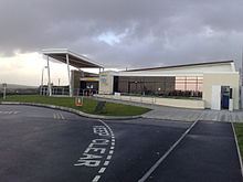 Newquay Cornwall Airport
Newquay Cornwall Airport provides links to many other parts of the United Kingdom. It is an HM Customs port, because it also handles increasing numbers of foreign flights, both scheduled and chartered. Newquay (NQY) is the principal airport for Cornwall, although there are several minor airfields elsewhere in the county and a Heliport at Penzance for Isles of Scilly traffic.
Until 2008, Newquay Civil Airport (as it was formerly known) used the runway and other facilities of RAF St Mawgan, but in December 2008 the Ministry of Defence handed over most of the site to the recently formed Cornwall Airport Limited. The first stage of the conversion into a fully commercial airport is now complete, although further substantial development is planned.[27] The handover, which was due to take place at the end of 2008, was delayed for almost three weeks because of problems in obtaining the essential Civil Aviation Authority licence, which was withheld until further work had been carried out. Altogether, Newquay Cornwall Airport now offers more than twenty routes.[citation needed]
Bus
 Newquay Bus Station
National Express runs coaches from various parts of Great Britain to Newquay. Newquay has a good local bus network: the principal operator is Western Greyhound, but some services are provided by FirstGroup and Summercourt Travel. The bus station is in Manor Road, which runs parallel to the main shopping area of Bank Street.
Education
Newquay has one higher education campus, Cornwall College Newquay, which is a member of the Combined Universities in Cornwall Partnership. It offers foundation degree courses in Zoological Conservation, Marine Aquaculture, Animal Science and Wildlife Education and Media. Appropriately, the campus is close to Newquay Zoo in the Trenance Valley. There are also two secondary schools: Newquay Tretherras School is a state-funded specialist Technology College and Treviglas College is a specialist Business and Enterprise College.
World War II
Among many schools evacuated to Cornwall (notably Benenden Girls' School), 240 boys and 20 masters of Gresham's School were evacuated to the town from Holt, Norfolk, during the Second World War, between June 1940 and March 1944.[28]
Notable people associated with Newquay
- William Golding author of Lord of the Flies, was born in Newquay
- Singer-songwriter Ruarri Joseph lives in the Newquay area
- Former Sheffield Wednesday and Celtic footballer Chris Morris was born in Newquay
- Singer-songwriter James Morrison grew up in the Newquay area: he attended Treviglas College
- Phillip Schofield attended Newquay Tretherras School[29]
- John Coulson Tregarthen, naturalist and novelist
- Sir David Willcocks the choral conductor, organist, and composer was born here in 1919
- British painter Nicholas Charles Williams is based in Newquay
Twinning
Newquay in films
- The Headland Hotel next to Fistral Beach has been used in several films, including Wild Things (1998) and The Witches (1990).[30]
- The Beatles filmed part of the Magical Mystery Tour film in Newquay. Scenes were filmed at the Atlantic Hotel and Towan Beach.[31]
See also
References
- ^ Ordnance Survey: Landranger map sheet 200 Newquay & Bodmin ISBN 9780319229385
- ^ "Table KS01 work= Census 2001". ONS. http://www.statistics.gov.uk/statbase/ssdataset.asp?vlnk=8271&More=Y.
- ^ "The Barrowfields". http://www.newquaytowncouncilcornwall.co.uk/local/?i=36.
- ^ Cornwall County Council. "Archaeological work at Scarcewater reveals rare & interesting finds". http://www.cornwall.gov.uk/index.cfm?articleid=1143.
- ^ Interim account of 1939 excavation by C. K. Croft Andrew (1949)
- ^ It was part of the manor of Coswarth and consisted of one virgate (value 15d) with five sheep; Thorn (1979) entry 4.22
- ^ "A Short History of Newquay Harbour". http://www.artseer.com/stcolumb.net/artytype/newquayharbour/harbmain.htm. Retrieved 5 September 2010.
- ^ "Newquay article in Genuki". http://www.genuki.org.uk/big/eng/Cornwall/Newquay/. Retrieved 13 February 2010.
- '^ Pevsner, N. (1970) Cornwall'; 2nd ed. Penguin Books; p. 126
- ^ "Newquay Discovery Trial". http://newquay.oldcornwall.org.uk/misc/disctrail.shtml.
- ^ St Michael's appears on W. Jago's ecclesiastical map of Cornwall, 1877, in Cornish Church Guide
- ^ Mee, A. (1937) Cornwall. London: Hodder and Stoughton; pp. 156-57
- ^ "1976 temperature". KNMI. http://eca.knmi.nl/utils/monitordetail.php?seasonid=14&year=1995&indexid=TXx&stationid=2130.
- ^ "1987 temperature". KNMI. http://eca.knmi.nl/utils/monitordetail.php?seasonid=7&year=1987&indexid=TNn&stationid=1816.
- ^ "St Mawgan Climate". UKMO. http://www.metoffice.gov.uk/climate/uk/averages/19712000/sites/st.mawgan.html. Retrieved 12 Nov 2011.
- ^ "St Mawgan extremes". KNMI. http://eca.knmi.nl/utils/mapserver/anomaly.php?indexcat=**&indexid=TNn&year=1962&seasonid=18&create_image=true&minx=-528750.00000003&miny=-4659285.7142857&maxx=-312083.33333334&maxy=-4496785.7142857&MapSize=560%2C420&imagewidth=560&imageheight=420&mainmap.x=336&mainmap.y=207&CMD=QUERY_POINT&CMD=QUERY_POINT#bottom. Retrieved 12 Nov 2011.
- ^ Newquay Town Council Cornwall webpage
- ^ The Surfing Tribe - a History of Surfing in Britain by Roger Mansfield (chapter 3) ISBN 0952364654
- ^ "Surfing The Cribbar Newquay, Cornwall". http://www.rogermansfield.com/cribbar.html. Retrieved 2010-07-01.
- ^ Cornwall Beaches - Fistral Beach{{dubious|date=November 2011|reason=This is more of a spam site than a reliable source
- ^ http://www.thisiscornwall.co.uk/news/Fresh-bring-surf-reef-resort/article-1916918-detail/article.html
- ^ http://www.visitnewquay.org/do-newquay/nightlife.php
- ^ Newquay: The teenage invasion Daily Telegraph article from 6 June 2008
- ^ http://www.nhs.uk/ServiceDirectories/Pages/Hospital.aspx?id=5QP15
- ^ Network Rail
- ^ http://www.networkrail.co.uk/browseDirectory.aspx?dir=\RUS%20Documents\Route%20Utilisation%20Strategies\Great%20Western&pageid=4449&root=\RUS%20Documents\Route%20Utilisation%20Strategies
- ^ The Newquay Cornwall Airport Masterplan
- ^ Benson, S. G. G. & Evans, Martin Crossley (2002) I Will Plant Me a Tree: an Illustrated History of Gresham's School. London: James & James ISBN 0-907383-92-0
- ^ "Phillip Schofield Online". http://www.schofieldfans.co.uk/about.php.
- ^ [1]
- ^ The Beatles, John Lennon, Paul McCartney, Ringo Starr and George Harrison, Photo stock Archive by Chris Walter
External links
- Newquay Community Profile
- The Official Newquay Tourism website
- Newquay Town Council
- Newquay Old Cornwall Society
- Newquay at the Open Directory Project
Geography of Cornwall Unitary authorities Major settlements Bodmin • Bude • Callington • Camborne • Camelford • Falmouth • Fowey • Hayle • Helston • Launceston • Liskeard • Looe • Lostwithiel • Marazion • Newlyn • Newquay • Padstow • Par • Penryn • Penzance • Porthleven • Redruth • Saltash • St Austell • St Blazey • St Columb Major • St Ives • St Just-in-Penwith • St Mawes • Stratton • Torpoint • Truro • Wadebridge
See also: Civil parishes in CornwallRivers Topics History • Status debate • Flag • Culture • Places • People • The Duchy • Diocese • Politics • Hundreds/shires • Places of interest • full list...Civil parishes of St Austell and Newquay constituency  Carlyon • Colan • Crantock • Fowey • Grampound with Creed • Mawgan-in-Pydar • Mevagissey • Newquay • Pentewan Valley • Roche • St Austell • St Austell Bay • St Blaise • St Columb Major • St Dennis • St Enoder • St Ewe • St Goran • St Mewan • St Michael Caerhays • St Sampson • St Stephen-in-Brannel • St Wenn • Treverbyn • Tywardreath and ParCategories:
- Newquay
- Towns in Cornwall


Wikimedia Foundation. 2010.