- Mylor Churchtown
-
Coordinates: 50°10′38″N 5°03′19″W / 50.17715°N 5.05528°W
Main article: Mylor, Cornwall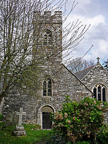 Mylor parish church
Mylor Churchtown is a coastal village in Cornwall, United Kingdom. It is situated at the mouth of Mylor Creek approximately five miles north of Falmouth.[1]
Mylor Harbour is a large yacht marina immediately north of Mylor Churchtown. The marina is at the mouth of Mylor Creek at its confluence with Carrick Roads and is the home of Restronguet Sailing Club.
The village is the church town of Mylor ecclesiastical parish.[2]
Mylor parish church (Anglican) is in Mylor Churchtown and is dedicated to St Melorus. The church has Norman origins. It is built on a cruciform plan and a south aisle was added in the 15th century. There is a small west tower but the bells are in a detached campanile.
Features of interest include 13th century carving of the Crucifixion outside the north transept, a 15th century pillar piscina and the Elizabethan pulpit. The well preseved rood screen has a the painted inscription in Cornish: "IARYS IONAI JESW CREST" (explained as a corrupT repainting of "MARYA JOHANNES JESUS CHRIST", i.e. Mary, John (the Evangelist), Jesus Christ). There are monuments to Francis Trefusis, one of the MPs for Penryn in 1679, dated 1680.[3][4][5] and to Reginald Cocks (1805) by Richard Westmacott.[6]
The cross in the churchyard is the largest in Cornwall (10 ft high).[7] The cross was only identified as such in 1870 as it had been buried head downwards in the earth so that the part above ground could serve as a post. The stone is 17 ft 6 in long and there is a local tradition that it marked the site of St Mylor's grave not far from the place where it was found. It was set up as it is now by sailors from HMS Ganges.[8][9] Thomas Peter's gravestone is the oldest in the churchyard; he was Vicar of Mylor but as a Royalist he was driven out of Cornwall and became the first minister at the settlement of New London afterwards returning to Mylor. There is also "a stone with a ship engraved on it, in memory of people drowned in the year before Waterloo" (Arthur Mee in Cornwall, 1937). This is for the over 250 victims of the shipwreck of the Queen, wrecked at Trefusis Point on a voyage from Spain to England.
References
- ^ Ordnance Survey: Landranger map sheet 204 Truro & Falmouth ISBN 9780319231494
- ^ [1] GENUKI website; Mylor. Retrieved April 2010
- ^ Pevsner, N. (1969) Cornwall; 2nd ed. Harmondsworth: Penguin; p. 125
- ^ Cornish Church Guide (1925) Truro: Blackford; p. 169
- ^ "In the chancel aisle kneels a young man born when Charles Stuart was about to die [1649]; he is Francis Trefusis, carved in stone."--Arthur Mee in his Cornwall; England's farthest south, London: Hodder & Stoughton, 1937.
- ^ Pevsner (1969); p. 125
- ^ Cornish Church Guide (1925) Truro: Blackford; pp. 168-69
- ^ Langdon, A. G. (1896) Old Cornish Crosses. Truro: Joseph Pollard; pp. 342-43
- ^ Iago, W. [Account of Mylor cross]. in: Journal of the Royal Institution of Cornwall; no. XI (April 1870), pp. 162-64
Geography of Cornwall Unitary authorities Major settlements Bodmin • Bude • Callington • Camborne • Camelford • Falmouth • Fowey • Hayle • Helston • Launceston • Liskeard • Looe • Lostwithiel • Marazion • Newlyn • Newquay • Padstow • Par • Penryn • Penzance • Porthleven • Redruth • Saltash • St Austell • St Blazey • St Columb Major • St Ives • St Just-in-Penwith • St Mawes • Stratton • Torpoint • Truro • Wadebridge
See also: Civil parishes in CornwallRivers Topics History • Status debate • Flag • Culture • Places • People • The Duchy • Diocese • Politics • Hundreds/shires • Places of interest • full list...Categories:- Villages in Cornwall
- Populated coastal places in Cornwall
- Marinas in the United Kingdom

Wikimedia Foundation. 2010.