- Mueang Mukdahan District
-
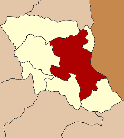
Mueang Mukdahan
เมืองมุกดาหาร— Amphoe — Amphoe location in Mukdahan Province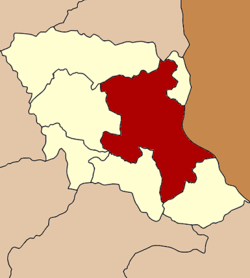
Coordinates: 16°32′17″N 104°42′53″E / 16.53806°N 104.71472°ECoordinates: 16°32′17″N 104°42′53″E / 16.53806°N 104.71472°E Country  Thailand
Province Mukdahan Seat Amphoe established Area – Total 1,235.07 km2 (476.9 sq mi) Population (2008) – Total 129,351 – Density 103.6/km2 (268.3/sq mi) Time zone THA (UTC+7) Postal code 49000 Geocode 4901 Mueang Mukdahan (Thai: เมืองมุกดาหาร) is the capital district (Amphoe Mueang) of Mukdahan Province, northeastern Thailand.
Contents
Geography
Neighboring districts are (from the southeast clockwise) Don Tan, Nikhom Kham Soi, Nong Sung, Khamcha-i, Dong Luang of Mukdahan Province, That Phanom of Nakhon Phanom Province and Wan Yai of Mukdahan Province again. To the east across the Mekong river is the Laotian province of Savannakhet.
The important water resource is the Mekong river.
History
The district goes back to the Mueang Mukdahan, which was administrated within the Monthon Udon Thani. In 1907 it was made a district of Nakhon Phanom Province. On September 27 1982 the southern part of Nakhon Phanom was split off to form the new province Mukdahan, and the district Mukdahan was renamed to Mueang Mukdahan as the capital district of the new province.[1]
Administration
The district is subdivided into 13 subdistricts (tambon), which are further subdivided into 144 villages (muban). The town (thesaban mueang) Mukdahan covers parts of tambon Mukdahan and the whole tambon Si Bun Rueang. The subdistrict municipality (thesaban tambon) Dong Yen covers the whole same-named tambon. There are further 12 Tambon administrative organizations (TAO).
No. Name Thai Villages Inh.[2] 1. Mukdahan มุกดาหาร 6 32,211 2. Si Bun Rueang ศรีบุญเรือง - 6,850 3. Ban Khok บ้านโคก 13 8,401 4. Bang Sai Yai บางทรายใหญ่ 12 8,421 5. Phon Sai โพนทราย 13 8,179 6. Phueng Daet ผึ่งแดด 13 5,557 7. Na Sok นาโสก 16 9,811 8. Na Si Nuan นาสีนวน 10 7,240 9. Kham Pa Lai คำป่าหลาย 17 12,034 10. Kham Ahuan คำอาฮวน 15 11,645 11. Dong Yen ดงเย็น 14 9,911 12. Dong Mon ดงมอน 10 5,387 13. Kut Khae กุดแข้ 6 3,704 References
- ^ "พระราชบัญญัติตั้งจังหวัดมุกดาหาร พ.ศ. ๒๕๒๕" (in Thai). Royal Gazette 99 (121 ก ฉบับพิเศษ): 14–17. 1982-08-27. http://www.ratchakitcha.soc.go.th/DATA/PDF/2525/A/121/14.PDF.
- ^ "Population statistics 2008". Department of Provincial Administration. http://www.dopa.go.th/xstat/p5149_01.html.
External links
- amphoe.com (Thai)
Categories:- Amphoe of Mukdahan
- Isan geography stubs
Wikimedia Foundation. 2010.