- Nong Phok District
-
Nong Phok
หนองพอก— Amphoe — Amphoe location in Roi Et Province
Coordinates: 16°18′35″N 104°12′11″E / 16.30972°N 104.20306°ECoordinates: 16°18′35″N 104°12′11″E / 16.30972°N 104.20306°E Country  Thailand
Province Roi Et Seat Nong Phok Tambon Muban Amphoe established Area – Total 599.5 km2 (231.5 sq mi) Population (2005) – Total 64,646 – Density 107.8/km2 (279.2/sq mi) Time zone THA (UTC+7) Postal code 45210 Geocode 4509 Nong Phok (Thai: หนองพอก) is a district (amphoe) in the northeastern part of Roi Et Province, northeastern Thailand.
Contents
Geography
Neighboring districts are (from the south clockwise) Selaphum, Phon Thong and Moei Wadi of Roi Et Province, Nong Sung of Mukdahan Province, and Loeng Nok Tha and Kut Chum of Yasothon Province.
History
The district goes back to the small village Ban Nong Phok, which was part of tambon Kok Pho, Phon Thong district. It was made a minor district (King Amphoe) on June 16, 1965, then consisting of the two tambon Kok Pho and Bueng Ngam.[1] It was upgraded to a full district on June 28, 1973.[2]
Places
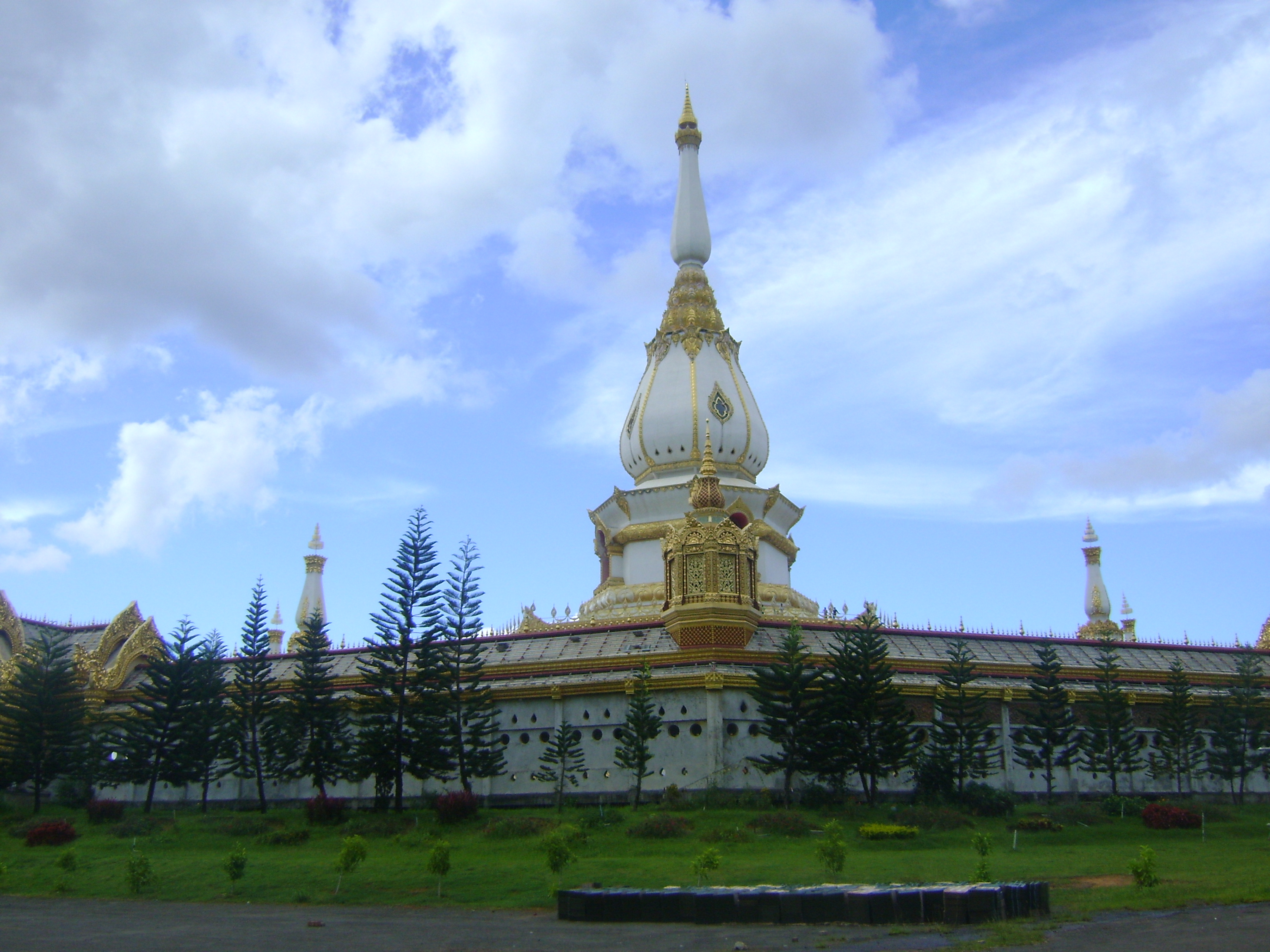
 Phra Maha Chedi Chai Mongkol
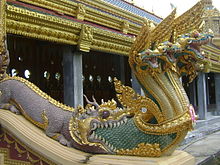 Phra Maha Chedi Chai Mongkol Naga emerging from mouth of Chinese dragon
Phra Maha Chedi Chai Mongkol (Thai: พระมหาเจดีชัยมงคล) located on the premises of Wat Pha Namthip Thep Prasit Vararam is one of the largest chedis in Thailand. It measures 101 metres wide, 101 metres long and 101 metres high. The chedi is on 101 rai (16.16 hectares, very nearly 40 acres.) The number 101 symbolises the name of the province: “Roi-et” is one hundred one in Thai numerals. The five-tiered chedi containing Buddha relics is decorated with elaborate designs in a contemporary style. The sides of the stairway leading into the central courtyard recall legendary origins in China and subsequent adoption of Buddhism with multi-headed Nāgas emerging from the mouth of Chinese dragons.
Administration
The district is subdivided into 9 subdistricts (tambon), which are further subdivided into 120 villages (muban). Nong Phok is a township (thesaban tambon) which covers parts of the tambon Nong Phok and Rop Mueang. There are further 9 Tambon administrative organizations (TAO).
No. Name Thai name Villages Inh. 1. Nong Phok หนองพอก 14 9,118 2. Bueng Ngam บึงงาม 11 5,392 3. Phukhao Thong ภูเขาทอง 17 9,611 4. Kok Pho กกโพธิ์ 12 6,435 5. Khok Sawang โคกสว่าง 10 4,651 6. Nong Khun Yai หนองขุ่นใหญ่ 13 7,955 7. Rop Mueang รอบเมือง 19 9,555 8. Pha Nam Yoi ผาน้ำย้อย 13 6,015 9. Tha Sida ท่าสีดา 11 5,914 References
- ^ "ประกาศกระทรวงมหาดไทย เรื่อง แบ่งท้องที่ตั้งเป็นกิ่งอำเภอ" (in Thai). Royal Gazette 81 (47 ง): 1616-. June 15, 1965. http://www.ratchakitcha.soc.go.th/DATA/PDF/2508/D/047/1616.PDF.
- ^ "พระราชกฤษฎีกาตั้งอำเภอเขาพนม อำเภอสนามชัยเขต อำเภอแม่อาย อำเภอขามสะแกแสง อำเภอเก้าเลี้ยว อำเภอโพธิ์ประทับช้าง อำเภอหนองพอก อำเภอละอุ่น อำเภอทุ่งหว้า และอำเภอศรีธาตุ พ.ศ. ๒๕๑๖" (in Thai). Royal Gazette 90 (75 ก special): 32–36. June 28, 1973. http://www.ratchakitcha.soc.go.th/DATA/PDF/2516/A/075/32.PDF.
External links
- amphoe.com (Thai)
Mueang Roi Et · Kaset Wisai · Pathum Rat · Chaturaphak Phiman · Thawat Buri · Phanom Phrai · Phon Thong · Pho Chai · Nong Phok · Selaphum · Suwannaphum · Mueang Suang · Phon Sai · At Samat · Moei Wadi · Si Somdet · Changhan · Chiang Khwan · Nong Hi · Thung Khao Luang
Categories:- Amphoe of Roi Et
- Buddhist monasteries in Thailand
- Buddhist temples in Roi Et Province
- Theravada Buddhist temples
- Buddhist art and culture
- Religion in Thailand
- Thai art
- Isan geography stubs


Wikimedia Foundation. 2010.