- Don Tan District
-
Don Tan
ดอนตาล— Amphoe — Amphoe location in Mukdahan Province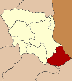
Coordinates: 16°19′0″N 104°55′12″E / 16.316667°N 104.92°ECoordinates: 16°19′0″N 104°55′12″E / 16.316667°N 104.92°E Country  Thailand
Province Mukdahan Seat Don Tan Amphoe established 1963 Area - Total 510.92 km2 (197.3 sq mi) Population (2008) - Total 42,215 - Density 81.3/km2 (210.6/sq mi) Time zone THA (UTC+7) Postal code 49120 Geocode 4903 Don Tan (Thai: ดอนตาล) is the southeasternmost district (Amphoe) of Mukdahan Province, northeastern Thailand.
Contents
History
Originally Don Tan was a Tambon of Mukdahan district, Nakhon Phanom Province. Don Tan was upgraded to a minor district (King Amphoe) in 1963,[1] which was further upgraded to a full district in 1974.[2] When the government established Mukdahan Province in 1982, Don Tan district was assigned to be a district of the new province.[3]
Geography
Neighboring districts are (from the southeast clockwise) Chanuman of Amnat Charoen province, Loeng Nok Tha of Yasothon Province, Nikhom Kham Soi and Mueang Mukdahan of Mukdahan Province. To the east across the Mekong river is the Laotian province of Savannakhet.
The important water resource is the Mekong river.
Administration
The district is subdivided into 7 subdistrict (tambon), which are further subdivided into 62 villages (muban). Don Tan is a subdistrict municipality (thesaban tambon) which covers parts of the tambon Don Tan. There are further 7 Tambon administrative organizations (TAO).
No. Name Thai Villages Inh.[4] 1. Don Tan ดอนตาล 12 7,013 2. Pho Sai โพธิ์ไทร 7 4,686 3. Pa Rai ป่าไร่ 11 8,609 4. Lao Mi เหล่าหมี 9 6,595 5. Ban Bak บ้านบาก 7 5,432 6. Na Sameng นาสะเม็ง 9 7,047 7. Ban Kaeng บ้านแก้ง 7 2,833 References
- ^ "ประกาศกระทรวงมหาดไทย เรื่อง แบ่งท้องที่ตั้งเป็นกิ่งอำเภอ" (in Thai). Royal Gazette 80 (14 ง): 221. 1963-02-05. http://www.ratchakitcha.soc.go.th/DATA/PDF/2506/D/014/221.PDF.
- ^ "พระราชกฤษฎีกาตั้งอำเภอเขาวง อำเภอเชียงม่วน อำเภอดอนตาล อำเภอชาติตระการ อำเภอภูเรือ อำเภอเคียนซา อำเภอน้ำโสม อำเภอหนองวัวซอ และอำเภอน้ำยืน พ.ศ. ๒๕๑๗" (in Thai). Royal Gazette 91 (54 ก ฉบับพิเศษ): 30–33. 1974-03-28. http://www.ratchakitcha.soc.go.th/DATA/PDF/2517/A/054/30.PDF.
- ^ "พระราชบัญญัติตั้งจังหวัดมุกดาหาร พ.ศ. ๒๕๒๕" (in Thai). Royal Gazette 99 (121 ก ฉบับพิเศษ): 14–17. 1982-08-27. http://www.ratchakitcha.soc.go.th/DATA/PDF/2525/A/121/14.PDF.
- ^ "Population statistics 2008". Department of Provincial Administration. http://www.dopa.go.th/xstat/p5149_01.html.
External links
- amphoe.com (Thai)
Categories:- Amphoe of Mukdahan
- Isan geography stubs

Wikimedia Foundation. 2010.