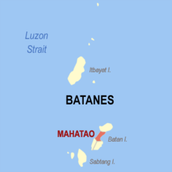
- Mahatao, Batanes
-
Mahatao — Municipality — Map of Batanes showing the location of Mahatao. Location in the Philippines Coordinates: 20°25′N 121°57′E / 20.417°N 121.95°ECoordinates: 20°25′N 121°57′E / 20.417°N 121.95°E Country  Philippines
Region Cagayan Valley (Region II) Province Batanes District Lone District Founded Barangays 4 Government - Mayor Pedro F. Poncio Area - Total 12.90 km2 (5 sq mi) Population (2007) - Total 1,539 - Density 119.3/km2 (309/sq mi) Time zone PST (UTC+8) ZIP code 3901 Income class 6th class Population Census of Mahatao Census Pop. Rate 1995 1,556 — 2000 1,895 4.32% 2007 1,539 -2.83% Mahatao is a 6th class municipality in the province of Batanes, Philippines. According to the latest census, it has a population of 1,707 people in 188 households.
Barangays
Mahatao is politically subdivided into 4 barangays.
- Hanib
- Kaumbakan
- Panatayan
- Uvoy (Pob.)
External links
- Philippine Standard Geographic Code
- 1995 Philippine Census Information
- 2000 Philippine Census Information
- 2007 Philippine Census Information
Municipalities Categories:- Philippines geography stubs
- Municipalities of Batanes
Wikimedia Foundation. 2010.


