- Mona Passage
-
Coordinates: 18°30′N 68°0′W / 18.5°N 68°W
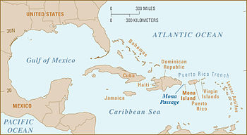 Location of the Mona Passage
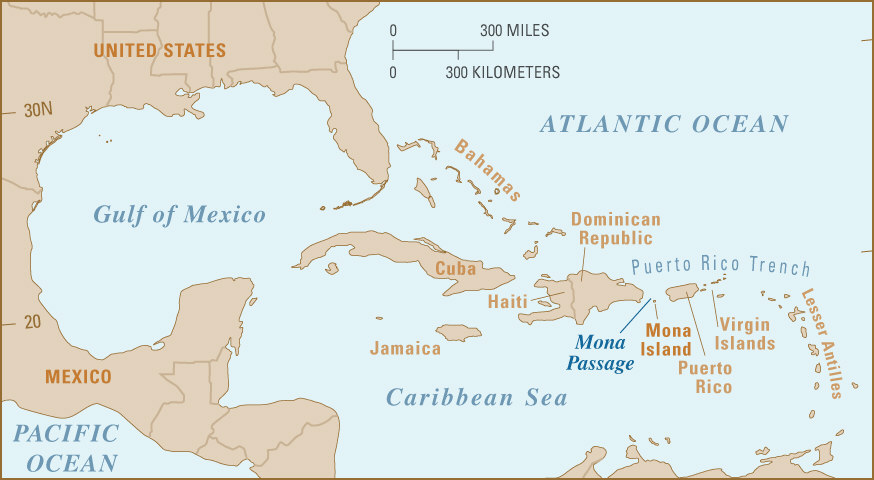
The Mona Passage is a strait that separates the islands of Hispaniola and Puerto Rico. The Mona Passage connects the Atlantic Ocean to the Caribbean Sea, and is an important shipping route between the Atlantic and the Panama Canal.
The 80 mi (130 km) stretch of sea between the two islands is one of the most difficult passages in the Caribbean. It is fraught with variable tidal currents created by the large islands on either side of it, and by sand banks that extend out for many miles from both coasts.
Contents
Islands
There are three islands in the Mona Passage:
Mona Island lies close to the middle of the Mona Passage.
Five kilometers northwest of Mona Island is much smaller Monito Island.
Fifty kilometers northeast of Mona Island and much closer (21 km) to the Puerto Rican mainland is Desecheo Island.
Structure and seismicity
The Passage was also the site of a devastating earthquake and resulting tsunami that hit western Puerto Rico in 1918.[1] It is the site of frequent small earthquakes. The passage is underlain by a seismically active rift zone that overprints an older partly eroded tilted-block structure.[1] Desecheo Island sits on the Desecheo ridge, a narrow east - west ridge that extends west from the northwest corner of Puerto Rico. The ridge forms the southern boundary of the 4000 m deep Mona rift which extends toward the north to the strike slip fault zones which bound Puerto Rico and Hispanola. The east face of the rift has a sharp relief of 3 km and is controlled by the N - S trending Mona Rift Fault. The epicenter of the 1918 earthquake was located along the east or southeast edge of the Mona Rift.[2]
Boating
Most cruising boaters entering the Caribbean from the north do so via a stop at Samaná in the northeastern part of the Dominican Republic, then continuing across the Mona Passage to Puerto Rico without stopping. Under sail it means an even longer distance because of having to "tack" a zig-zag course into the easterly trade winds.
At the stop of Saona Island on the southeast coast of the Dominican Republic, boaters can sit and wait for a lull in the trade winds when seas are down to start their eastward crossing. This is an advantage which is not possible when departing from Samaná. It is only about 40 miles (64 km) from Saona to the protected anchorage inside the barrier coral reef on the west coast of Mona Island. And from there it is another 40 miles (64 km) to the popular and spacious cruising anchorage at Boquerón in Puerto Rico.
References
- ^ a b http://soundwaves.usgs.gov/2007/05/ Uri ten Brink, New Bathymetric Map of Mona Passage, Northeastern Caribbean, Aids in Earthquake- and Tsunami-Hazard Mitigation, USGS Sound Waves Newsletter, May 2007
- ^ Mann, Paul, Active Tectonics and Seismic Hazards of Puerto Rico, the Virgin Islands, and Offshore Areas, Special Paper, Geological Society of America, 2005 p. 118 - 119 ISBN 978-0813723853
Categories:- Geography of Puerto Rico
- Geography of Hispaniola
- Straits of the Caribbean
- Dominican Republic–Puerto Rico border
- International straits
- Oceanography stubs
Wikimedia Foundation. 2010.