Birsig

Birsig

Infobox_River
river_name = Birsig


image_size =
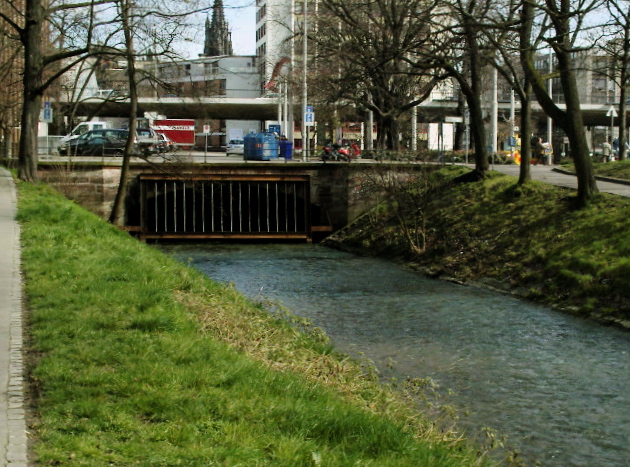
caption = Beginning of the Birsig's overbuilding near the Basel zoo
origin =
mouth = Rhine
coord|47|33|37|N|7|35|17|E|name=Rhine-Birsig|display=inline,title
basin_countries = France, Switzerland
length = 21 km
elevation =
mouth_elevation =
discharge =
watershed = 82 m2
The Birsig is a small river in eastern France and northern Switzerland. Its source is in the village Biederthal, in the French Haut-Rhin department, near the Swiss border. The Birsig is about 21 kilometers long and its watershed area is about 82 square kilometers. It flows variably through Swiss and French territory and through the Birsig Valley. Afterwards it passes the city of Basel, where it enters the Rhine river (left bank).

The Birsig river originally flowed openly through Basel, but its banks had been built up and forced early to prevent water damage to the houses. The river flowed directly along the houses in the lower part of the city, where many bridges were built over. It took the fecal waste from the houses and was therefore called "the city's big cloaca", which favoured the outbreak of cholera and typhus.

Nowadays the Birsig river is overbuilt in Basel; there are just a few hundred meters around the city zoo where the Birsig river can be seen openly.

External links

;Maps, photos, and other
http://www.basel.ch/?nav=218&lang=en Photography of the Birsig kloak]

References

*http://www.geoportail.fr


Wikimedia Foundation. 2010.

Игры ⚽ Нужна курсовая?

Look at other dictionaries:

  • Birsig — / Boersegraben Beginn der Eindolung des Birsig in der Nähe des Zoologischen GartensVorlage:Infobox Fluss/KARTE fehlt …   Deutsch Wikipedia

  • Birsig — Birsig, Flüßchen im Schweizercanton Basel, kommt aus dem Sundgau, fließt durch die Stadt in den Rhein …   Pierer's Universal-Lexikon

  • Birsig — Birsig, ein kleines Juragewässer in der Schweiz, dem Lauf der Birs (s. d.) benachbart und parallel, aber im Oberlauf durch den Blauen Berg, weiter unten durch die geschichtlich denkwürdigen Höhen des Bruderholzes (1499) vom Birsgebiet getrennt,… …   Meyers Großes Konversations-Lexikon

  • Birsig — 47°33′37″N 7°35′17″E / 47.56028, 7.58806 …   Wikipédia en Français

  • Börsegraben — Birsig Birsig Caractéristiques Longueur 21 km Bassin 82 km2 …   Wikipédia en Français

  • Бирзиг — (Birsig) левый приток Рейна, начинается в 17 км к ЮЗ. от Базеля, течет по близости р. Бирса и параллельно ему, но в верхнем течении отделяется от области Бирса Синей Горой, а ниже замечательными в историческом отношении высотами так наз.… …   Энциклопедический словарь Ф.А. Брокгауза и И.А. Ефрона

  • Rümelinbach — RümelinbachVorlage:Infobox Fluss/GKZ fehlt Lage Kantone Basel Landschaft und Basel Stadt, Schweiz Flusssystem RheinVorlage:Infobox Fluss/FLUSSSYSTEM falsch …   Deutsch Wikipedia

  • Dorenbach — DorenbachVorlage:Infobox Fluss/GKZ fehlt Lage Kanton Basel Landschaft, Kanton Basel Stadt; Schweiz Flusssystem Birsig→RheinVorlage:Infobox Fluss/FLUSSSYSTEM falsch Vorlage:Infob …   Deutsch Wikipedia

  • Heuwaage — 47.5511305555567.58729722222227Koordinaten: 47° 33′ 4,1″ N, 7° 35′ 14,3″ O; CH …   Deutsch Wikipedia

  • Bachletten — Quartier von Basel Koordinaten …   Deutsch Wikipedia

Share the article and excerpts

Direct link
Do a right-click on the link above
and select “Copy Link”