- Tangipahoa River
Geobox River
name = Tangipahoa River
native_name =
other_name =
other_name1 =
image_size = 200 px
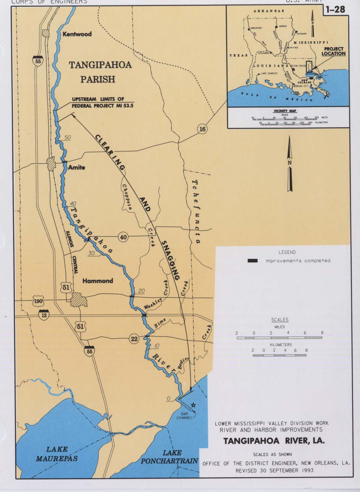
image_caption = Map of the Tangipahoa River, LA
country =United States
country1 =
state =Mississippi
state1 =Louisiana
region_type = County/Parish
region = Pike County Amite County Lincoln County Tangipahoa Parish
region1 =
district =
district1 =
city =Osyka, Mississippi Kentwood, Louisiana Amite, Louisiana
city1 =Hammond, Louisiana
length_imperial = 110
watershed_imperial =
discharge_location =
discharge_imperial =
discharge_max_imperial =
discharge_min_imperial =
discharge1_location =
discharge1_imperial =
source_name = Little Tangipahoa River
source_location = Osyka, Pike County
source_district =
source_region =
source_state =Mississippi
source_country =
source_lat_d = 31
source_lat_m = 06
source_lat_s = 29
source_lat_NS = N
source_long_d = 90
source_long_m = 28
source_long_s = 32
source_long_EW = W
source_elevation_imperial = 269
source_length_imperial =
mouth_name =Lake Pontchartrain
mouth_location = Southeast Ponchatoula
mouth_district =
mouth_region =Tangipahoa Parish
mouth_state =Louisiana
mouth_country =
mouth_lat_d = 30
mouth_lat_m = 20
mouth_lat_s = 12
mouth_lat_NS = N
mouth_long_d = 90
mouth_long_m = 16
mouth_long_s = 26
mouth_long_EW = W
mouth_elevation_imperial = -3
tributary_left =
tributary_left1 =
tributary_right =
tributary_right1 =
free_name =
free_value =
map_size =
map_caption =The Tangipahoa River (IPA2|tænˈdʒɪpəhoʊə in English; tan-juh-puh-HO-uh) originates northwest of McComb in southwest
Mississippi , and runs south 110 miles through the Percy Quin Reservoir before passing into southeast Louisiana. Its mouth opens into the northwest region ofLake Pontchartrain . [ [http://www.bartleby.com/69/56/T01156.html The Columbia Gazetteer of North America. 2000.] ]Alternate/historical names and spellings: [ [http://geonames.usgs.gov/pls/gnispublic/f?p=133:3:2256349563441453058::NO::P3_FID:556198 USGS Geographic Names Information System - Tickfaw River] ]
*Rio Tanchipaho
*Taensapaoa River
*Tanchipaho River
*Tanchipao River
*Tandgepao River
*Tandgi-pao River
*Tangipaho River
*Tansypaho River
*Tanzipao River
*Taugipahoa River
*Tuckepaw River
*Big Tangipahoa RiverReferences
External links
* [http://geonames.usgs.gov/pls/gnispublic/f?p=133:3:2256349563441453058::NO::P3_FID:672695 USGS Geographic Names Information System - Little Tangipahoa River]
* [http://cfpub.epa.gov/surf/huc.cfm?huc_code=08070205 US EPA Tangipahoa Watershed]
* [http://www.mvn.usace.army.mil/eng2/edsd/proj_maps/pm1-28.jpgArmy Corps of Engineers Map of the Tickfaw River]
* [http://www.mvn.usace.army.mil/eng2/edsd/proj_maps/pmap_rah2.htm US Army Corps of Engineers River and Harbor Act Projects - New Orleans District]
Wikimedia Foundation. 2010.