- Ninety East Ridge
-


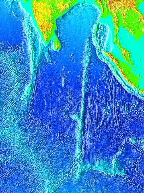
The Ninety East Ridge (also rendered as Ninetyeast Ridge, 90E Ridge or 90°E Ridge) is a linear, aseismic, age-progressive seamount chain in the Indian Ocean and is named for its near-parallel strike along the 90th meridian. It is approximately 5,000 kilometres (3,100 mi) in length and can be traced topographically from the Bay of Bengal southward towards the Southeast Indian Ridge (SEIR), though the feature continues to the north where it is hidden beneath the sediments of the Bengal Fan. The ridge extends between latitudes 33°S and 17°N and has an average width of 200 km.[1]
The ridge dissects the Indian Ocean into the West and East Indian Ocean. The northeastern side is named the Wharton Basin and ceases at the western end of the Diamantina Fracture Zone which passes to the east and almost to the Australian continent.[2]
The ridge is primarily composed of Ocean Island Tholeiites (OIT), a subset of basalt which increase in age from approximately 43.2 ± 0.5 Ma in the south to 81.8 ± 2.6 Ma in the north[3] though a more recent analysis using modern Ar-Ar techniques is currently pending publication. This age progression has led geologists to theorize that a hotspot in the mantle beneath the Indo-Australian Plate created the ridge as the plate has moved northward in the late Mesozoic and Cenozoic. This theory is supported by a detailed analysis of the chemistry of the Kerguelen Plateau and Rajmahal Traps, which together, geologists believe, represent the flood basalts erupted at the initiation of volcanism at the Kerguelen hotspot which was then sheared in two as the Indian subcontinent moved northward.[3] However, the existence of so-called deep mantle hotspots is currently a topic of debate in the geologic community, with many geochemists favoring an alternative hypothesis which postulates a much shallower origin for hotspot volcanism.[4]
The ridge has been surveyed several times in the past, including several times by the Deep Sea Drilling Program (DSDP). In 2007, the RV Roger Revelle collected bathymetric, magnetic and seismic data together with dredge samples from nine sites along the ridge as part of an Integrated Ocean Drilling Program (IODP) site survey intended to examine the hotspot hypothesis for the ridge.[5]
References
- ^ Ramana, M.V.; T. Ramprasad, M. Desa, V. Subrahmanyam (2000). "Integrated geophysical studies over the 85°E ridge - Evaluation and interpretation". Visakha Science Journal 4 (1): 45–56. http://drs.nio.org/drs/handle/2264/428.
- ^ Stow, D. A. V. (2006) Oceans : an illustrated reference Chicago : University of Chicago Press, ISBN 0226776646 - page 127 for map of Indian Ocean and ridges
- ^ a b Weis, D.; et al. (1993). "The Influence of Mantle Plumes in Generation of Indian Oceanic Crust". Geophysical Monograph 70: 57–89.
- ^ King, S. D.; Anderson, D. L. (1995). "An Alternative Mechanism of Flood Basalt Formation". Earth and Planetary Science Letters 136 (3–4): 269–279. doi:10.1016/0012-821X(95)00205-Q.
- ^ "Seismic Project Information KNOX06RR Ninetyeast Ridge IODP Survey". The University of Texas at Austin. http://www.ig.utexas.edu/sdc/cruise.php?cruiseIn=knox06rr.
Further reading
- Sager, William W. (2007). "Cruise Report KNOX06RR R/V Roger Revelle 18 June to 6 August, 2007, Phuket to Singapore". Scripps Institution of Oceanography. http://www.marine-geo.org/tools/search/data/field/Revelle/KNOX06RR/docs/KNOX06RR_CruiseRept.pdf.
- Nobre Silva, I. G. (2011). Deciphering mantle source components in basalts from hotspot tracks and oceanic islands. University of British Columbia. https://circle.ubc.ca/handle/2429/33960?show=full.
- Sager, W. W.; Paul, C.F., Krishna, K.S., Pringle, M.S., Eisin, A.E., Frey, F.A., Rao, D.G., Levchenko, O.V. (September 2010). "Large fault fabric of the Ninetyeast Ridge implies near-spreading ridge formation". Geophysical Research Letters (American Geophysical Union) 37 (L17304). doi:10.1029/2010GL044347. http://drs.nio.org/drs/bitstream/2264/3723/1/Geophys_Res_Lett_37_L17304a.pdf.
- Verzhbitsky, E. V. (2003). "Geothermal regime and genesis of the Ninety-East and Chagos-Laccadive ridges". Journal of Geodynamics 35 (3): 289–302. doi:10.1016/S0264-3707(02)00068-6.
Categories:- Plate tectonics
- Underwater ridges of the Indian Ocean
Wikimedia Foundation. 2010.