Washington State Route 211
- Washington State Route 211
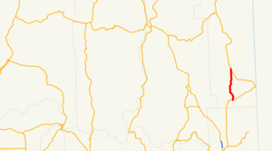
Infobox WA State Route
type=State
route=211
sec=
parent_type=WA
parent=20
length_mi=15.18
length_ref=[cite web|author=Washington State Department of Transportation|url=http://www.wsdot.wa.gov/mapsdata/tdo/PDF_and_ZIP_Files/HwyLog2006.pdf|title=State Highway Log, 2006|accessdate=2007-04-22] ]
length_round=2
formed=1964 (as SR 311)
dir2=South
dir1=North
to= at Sacheen Lake
from= at Usk
previous_type=WA
previous_route=207
next_type=WA
next_route=215
State Route 211 is a state highway in the U.S. state of Washington, running from US 2 at Sacheen Lake to SR 20 at Usk.
History
Before SR 20 took the Tiger to Newport section of SR 31, SR 211 was SR 311. In 1967, SR 311 became the current SR 211.
Before 1964, SR 311 was SSH 6B. [ [http://www.angelfire.com/wa2/hwysofwastate/sr211.html Highways of Washington State] Retrieved April 2, 2008]
Major intersections
*
*
References
Wikimedia Foundation.
2010.
Look at other dictionaries:
Washington State Route 31 — State Route 31 Nearby state routes with SR 31 highlighted in red. Route inform … Wikipedia
Washington State Route 20 — State Route 20 Whidbey Scenic Isle Way North Cascades Highway … Wikipedia
Washington State Route 213 — Infobox WA State Route|type=State|route=213|parent type=State|parent=21|sec=417 length mi= length ref= length round=0 dir1=North|dir2=South from= to= previous type=WA previous route=211 next type=WA next route=215State Route 213 is a proposal for … Wikipedia
Washington State Route 207 — Infobox WA State Route type=State route=207 sec= parent type=US parent=2 length mi=4.38 length ref=cite web|author=Washington State Department of Transportation|url=http://www.wsdot.wa.gov/mapsdata/tdo/PDF and ZIP Files/HwyLog2006.pdf|title=State … Wikipedia
Washington State Route 215 — Infobox WA State Route type=State route=215 sec= parent type=WA parent=20 length mi=6.24 length ref=cite web|author=Washington State Department of Transportation|url=http://www.wsdot.wa.gov/mapsdata/tdo/PDF and ZIP… … Wikipedia
New York State Route 17M — Basisdaten Gesamtlänge: 26,63 mi. / 42,86 km Eröffnung: … Deutsch Wikipedia
Ohio State Route 39 — State Route 39 Route information Maintained by ODOT Length: 154.28 mi[1 … Wikipedia
New York State Route 17M — NYS Route 17M … Wikipedia
California State Route 1 — For other uses, see CA1 (disambiguation). State Route 1 Route information … Wikipedia
Interstate 210 and State Route 210 (California) — Interstate 210, State Route 210 Foothill Freeway … Wikipedia
