- Monomoy Island
-
Coordinates: 41°33′0″N 70°0′0″W / 41.55°N 70°W
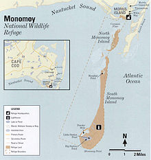
Monomoy Island is an 8 mile (13 km) long spit of sand extending southwest from Chatham, Cape Cod off the Massachusetts mainland.
History
It was taken over by the US government just before World War II. The island was home to the Monomoy Island Gunnery Range until 1944 when the Monomoy National Wildlife Refuge was established.
Despite its remoteness Monomoy was home to its own community as early as 1710. A tavern for sailors was opened up in the location of today's Hospital Pond, known then as Wreck Cove.
During the early 19th century a deep natural harbor at Monomoy's inner shore, known as the Powder Hole, attracted a sizeable fishing settlement. In its prime Whitewash Village housed about 200 residents, a tavern inn called Monomoit House, and Public School #13, which at one time boasted 16 students. Cod and mackerel brought in to the Monomoy port were dried and packed for markets in Boston and New York. Lobsters were also plentiful, providing both food and income for the villagers, who peddled them to mainlanders at about two cents apiece.
The village was abandoned after its harbor was washed away by a hurricane around 1860. A storm in the spring of 1958 carved a wide shallow channel between Morris Island and Monomoy, separating it from the mainland. The Blizzard of 1978 further divided the island into North Monomoy and South Monomoy. A storm during the winter of 2006-2007 once again reconnected South Monomoy to the mainland, although North Monomoy remains an island. The island was designated in 1970 a Federal Wildlife Refuge, serving as an important stop on the migratory routes of 285 species of birds. Since gaining Federal protection in 1972, Gray seals have become a common sight on Monomoy and nearby Chatham's South Beach island.
Monomoy has no human residents, no electricity, no paved roads; today, in fact, the only reminder of Monomoy's habitation is the Monomoy Point Light, which guided from 1828 to 1923. The wooden lightkeeper's quarters, the cast iron light tower, and the brick generator house are alone on the desolate point of the South Island.
External links
Categories:- Chatham, Massachusetts
- Islands of Massachusetts
- Landforms of Barnstable County, Massachusetts
Wikimedia Foundation. 2010.

