- Mitchell Point Tunnel
-
 Inside the tunnel
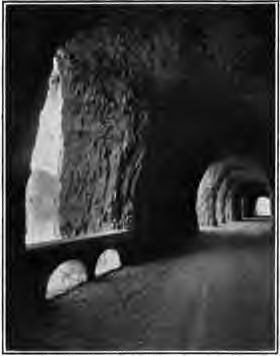
The Mitchell Point Tunnel was a tunnel located towards the eastern end of the Historic Columbia River Highway in Oregon, United States. It existed from 1915 to 1966.
History
 Looking up from the river
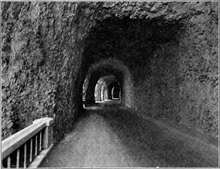 Entrance to the tunnel
The Mitchell Point Tunnel was designed by Oregon State Highway Engineer John Arthur Elliott. Completed in 1915, it served as a major automobile and truck route until the opening of a water grade route through Columbia River Gorge in 1954.
The Mitchell Point Tunnel was blasted through solid rock high up on the bluff of Mitchell Point, 95 feet (29 m) above the Columbia River. Its five windows, carved through basaltic rock, afforded a scenic view of the Columbia River Gorge. Motorists could pause and enjoy watching steamboats plying the Columbia River far below, or gaze up at rugged, snow capped volcanoes Mount Adams and Mount St. Helens.
The Mitchell Point Tunnel was a prominent feature of the Columbia River Highway, now known as the Historic Columbia River Highway. This famous roadway stretched 125 miles (200 km) along the Oregon side of the Columbia River between Portland and The Dalles. The road is recognized as an engineering marvel and as America's first scenic highway.
Although the tunnel's two-way, 18-foot (5.5 m) roadbed was considered adequate by 1915 standards, vehicles became larger and wider during the 1920s. Truck traffic also became more common on the highway. Eventually, a signal was installed at each entry of the tunnel, alternately allowing east and west, one-way traffic to avert collisions.
By the 1930s, the tunnel was considered inadequate for modern traffic. A wider, river-level route (now designated U.S. Route 30) was built at the base of Mitchell Point around 1954. The five famous windows were bricked up, the tunnel filled with rock, and the viaducts leading to the tunnel were blocked.
The once-celebrated tunnel remained abandoned, but intact, until 1966 when the Mitchell Point Tunnel was destroyed during the widening of Interstate 84.
There are now plans to re-create the tunnel by the Oregon Department of Transportation as part of its ongoing restoration of the Historic Columbia River Highway.
External links
- Vintage Postcards of Mitchell Point Tunnel
- Historic American Engineering Record report on Mitchell Point Tunnel
- Article about the tunnel's engineer from the University of Washington alumni magazine
Coordinates: 45°42′15″N 121°37′01″W / 45.704096°N 121.616839°W
Categories:- Tunnels in Oregon
- Columbia River Gorge
- Historic Columbia River Highway
- Buildings and structures in Hood River County, Oregon
- Tunnels completed in 1915
- Oregon building and structure stubs


Wikimedia Foundation. 2010.