Allawah, New South Wales

Allawah, New South Wales

Infobox Australian Place | type = suburb
name = Allawah
city = Sydney
state = nsw


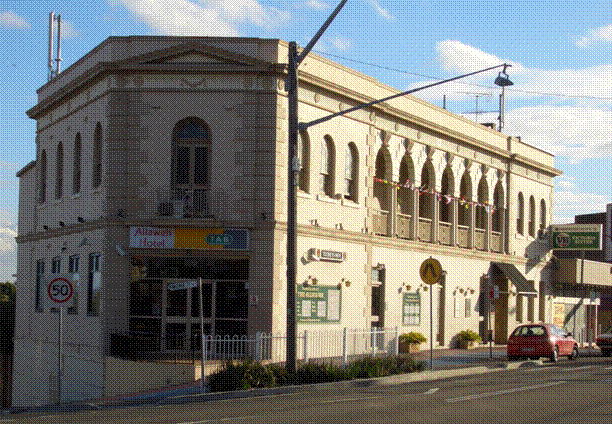
caption = Allawah Hotel, Railway Parade
lga = Municipality of Kogarah
lga2 = City of Rockdale
postcode = 2218
pop =
area =
propval =
est =
stategov = Kogarah
fedgov = Division of Barton
near-nw = Hurstville
near-n = Bexley
near-ne = Bexley
near-w = South Hurstville
near-e = Carlton
near-sw = Blakehurst
near-s = Carss Park
near-se = Carlton
dist1 = 15
location1= CBD

Allawah is a suburb in southern Sydney, in the state of New South Wales, Australia. Allawah is located 16 km south of the Sydney central business district and is part of the St George area. Allawah lies mostly in the local government area of the Municipality of Kogarah and partly in the City of Rockdale. The postcode is 2218, which is shared by the neighbouring suburb of Carlton. [Gregory's Sydney Street Directory, Gregory's Publishing Company, 2007]

Commercial area

Allawah is a small landlocked suburb, about 15-20 minutes walking distance from Hurstville. Allawah’s main shopping centre is located on Railway Parade, beside Allawah railway station. The Allawah shopping strip contains a newsagent, post office, corner store, real estate agent, take-away shops, an Italian restaurant called 'Little Italy' and the local watering hole and bottle shop, the Allawah Hotel.

Transport

Allawah railway station is on the City Rail Illawarra line. The railway station has had an upgrade in recent years, including the installation of lifts to benefit the mobility challenged. Trains stop at Allawah three times an hour during peak times, and twice an hour at all other times.

History

Allawah is an Aboriginal name meaning 'make your abode here' or 'remain here'.

The area was part of a land grant to Captain John Townson in 1808. The grant extended from King Georges Road and Stoney Creek Road to beyond Kogarah railway station. The railway line to Hurstville was opened in 1884 but the railway station at Allawah did not open until 23 October 1925. The post office opened in May 1933. [Book of Sydney Suburbs, Frances Pollon (Angus and Robertson) 1990]

Politics

Allawah is in the federal government division of Barton and state government electorate of Kogarah.

Landmarks

* St Raphaels Catholic Church, Illawarra Synagogue
* St Raphaels Catholic School

References

External links


Wikimedia Foundation. 2010.

Игры ⚽ Поможем решить контрольную работу

Look at other dictionaries:

  • South Hurstville, New South Wales — Infobox Australian Place | type = suburb name = South Hurstville city = Sydney state = nsw caption = Intersection of King Georges Connells Point Roads lga = Municipality of Kogarah postcode = 2221 pop = area = propval = est = stategov = Kogarah… …   Wikipedia

  • Kogarah, New South Wales — For the seat in the New South Wales Legislative Assembly, see Electoral district of Kogarah. For the local government area, see the Municipality of Kogarah. Kogarah Sydney, New South Wales …   Wikipedia

  • Hurstville, New South Wales — Infobox Australian Place | type = suburb name = Hurstville city = Sydney state = nsw caption = Memorial Square, Forest Road, Hurstville lga = City of Hurstville postcode = 2220 est = 1887 pop = 23,331 (2006) Census 2006 AUS | id = SSC11497 | name …   Wikipedia

  • Blacktown, New South Wales — Infobox Australian Place | type = suburb name = Blacktown city = Sydney state = nsw caption = St. Paraskevi Greek Orthodox Church, Blacktown lga = City of Blacktown postcode = 2148 est = pop = 39,000 area = propval = stategov = Blacktown fedgov …   Wikipedia

  • Carlton, New South Wales — Infobox Australian Place | type = suburb name = Carlton city = Sydney state = nsw caption = Carlton Parade, Carlton lga = City of Rockdale lga2 = Municipality of Kogarah postcode = 2218 pop = area = propval = est = 1886 stategov = Rockdale fedgov …   Wikipedia

  • Carss Park, New South Wales — Infobox Australian Place | type = suburb name = Carss Park city = Sydney state = nsw caption = Carwar Avenue, Carss Park lga = Municipality of Kogarah postcode = 2221 pop = area = propval = est = stategov = Kogarah fedgov = Division of Barton… …   Wikipedia

  • Connells Point, New South Wales — Connells Point Sydney, New South Wales Oatley Bay, Connells Point Population …   Wikipedia

  • South Coast railway line, New South Wales — Public transport infrastructure in Sydney logo= name=South Coast line transport mode=Interurban rail line Coach service line owner=CityRail operation area=Wollongong Shellharbour Kiama Shoalhaven map colour=Blue/Grey line length=153 km stations… …   Wikipedia

  • Hurstville — City of Hurstville Lage der Hurstville City in Sydney Basisdaten Bundesstaat: New South Wales Hauptort: Hurstville Fläche …   Deutsch Wikipedia

  • Hurstville City — City of Hurstville Lage der Hurstville City in Sydney Gliederung …   Deutsch Wikipedia

Share the article and excerpts

Direct link
Do a right-click on the link above
and select “Copy Link”