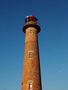
- Gorleston (Range Rear) Lighthouse
-
Gorleston (Range Rear) Lighthouse 
Gorleston (Range Rear) Lighthouse Location Gorleston on sea, Norfolk, England Coordinates 52°34′19.48″N 1°43′56.16″E / 52.5720778°N 1.7322667°ECoordinates: 52°34′19.48″N 1°43′56.16″E / 52.5720778°N 1.7322667°E Year first lit 1878 Construction Masonry Tower shape round red brick tower, Height 11 meters Characteristic Active aid to navigation. Gorleston (Range Rear) Lighthouse is located near mouth of River Yare in the town of Gorleston on sea in the English county of Norfolk.[1] The lighthouse was built in 1878. Gorleston lighthouse carries two lights. The rear light for the harbor entrance range (white light, 4 seconds on, 2 seconds off) is mounted on the tower with a focal plane of 23 feet; a fixed red light is also displayed from the gallery with a focal plane of 66 feet.
Gallery
References
- ^ Ordnance Survey (2005). OS Explorer Map OL40 - The Broads. ISBN 0-319-23769-9.
Cromer Lighthouse · Gorleston South Pier Lighthouse · Gorleston (Range Rear) Lighthouse · Happisburgh Lighthouse · RAF Neatishead · Old Hunstanton Lighthouse · RAF Trimingham · Winterton LighthouseCategories:- Buildings and structures in Norfolk
- Lighthouses in England
- Geography of Norfolk
- Coastal feature of Norfolk
- Gorleston
Wikimedia Foundation. 2010.

