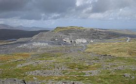
- Manod Mawr North Top
-
Manod Mawr North Top 
Manod Mawr North Top from Manod MawrElevation 658 m (2,159 ft) Listing Hewitt, Nuttall Translation great snowdrift (Welsh) Pronunciation Welsh: [ˈmanɔd ˈmauɾ] Location Location Gwynedd,  Wales
WalesRange Moelwynion Topo map OS Landranger 124 Manod Mawr North Top is a mountain in North Wales and forms part of the Moelwynion.
It lies directly to the north of its parent Manod Mawr, separated by the Graig Ddu quarry. Crossing the quarry to reach the main summit can be dangerous. There are also a few mine adits on the northern slopes.[1]
References
- ^ Nuttall, John & Anne (1999). The Mountains of England & Wales - Volume 1: Wales (2nd edition ed.). Milnthorpe, Cumbria: Cicerone. ISBN 1-85284-304-7.
External links
Coordinates: 52°59′01″N 3°54′13″W / 52.98348°N 3.90360°W
Categories:- Hewitts of Wales
- Mountains and hills of Snowdonia
- Nuttalls
- Gwynedd geography stubs
Wikimedia Foundation. 2010.
