- Loop Retail Historic District
Infobox_nrhp | name =Loop Retail Historic District
nrhp_type = hd
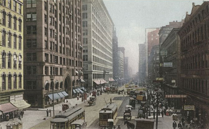
caption = State Street in 1907
location=Chicago, Illinois
locmapin = Illinois
area =26 acres
built =1871
architect= Holabird and Roche; Sullivan, Louis Henri, et al.
architecture= Italianate, Early Commercial, Chicago
added =November 27 ,1998 cite web|url=http://www.nr.nps.gov/|title=National Register Information System|date=2007-01-23|work=National Register of Historic Places|publisher=National Park Service]
governing_body = Local
refnum=98001351Loop Retail Historic District is a shopping district within the
Chicago Loop community area in city-state|Cook County|Illinois,United States . It is bounded by Lake Street to the north, Congress Parkway to the south, State Street to the west and Wabash Avenue to the east. The district has the highest density ofNational Historic Landmark ,National Register of Historic Places andChicago Landmark designated buildings in Chicago. It hosts several historic buildings including former department store flagship locationsMarshall Field and Company Building (nowMacy's at State Street), and theSullivan Center (formerly Carson, Pirie, Scott and Company Building). It was added to theNational Register of Historic Places onNovember 27 ,1998 .citation|title=PDFlink| [http://gis.hpa.state.il.us/hargis/PDFs/205556.pdf National Register of Historic Places Registration: Loop Retail Historic District] |32 KB|date=1998-06-01 |author=Raymond Terry Tatum |publisher=National Park Service (includes map of district)] It includes 74 contributing buildings and structures, including 13 separately listedRegistered Historic Places , and 22 non-contributing buildings. Other significant buildings in the district include theJoffrey Tower ,Chicago Theatre ,Palmer House , andPage Brothers Building . It also hostsDePaul University 's College of Commerce, which includes theKellstadt Graduate School of Business and theRobert Morris College .The district is most commonly associated with
department store buildings. In its heyday the district hosted seven prominent department stores from which six buildings remain today. These include the aforementioned Marshall Field and Company Building, and Carson, Pirie, Scott and Company Buildings as well as theNational Register of Historic Places A. M. Rothschild & Company Store () at 333 S. State St. The other department store buildings are contributing properties.History
The district's period of historic significance was 1872–1949. In the late
1860s ,Potter Palmer improved State Street by building his ownPalmer House hotel on State Street in1870 . [cite web|url=http://www.encyclopedia.chicagohistory.org/pages/947.html|publisher=Chicago Historical Society|date=2005|work=The Electronic Encyclopedia of Chicago|accessdate=2008-03-02|author=Moore, Anne|title=Palmer House] He had also convincedMarshall Field andLevi Leiter to move the Field, Leiter & Co. store to State Street in 1868. [cite web|url=http://chicago.urban-history.org/ven/dss/fields.shtml|title=Marshall Field and Company|accessdate=2008-03-02|publisher=Scott A. Newman|work=Jazz Age Chicago|date=2006-05-11 ] Chicago's retailing center was State Street (anchored byMarshall Field's ) in the downtown Loop after theGreat Chicago Fire of 1871.cite web|url=http://www.encyclopedia.chicagohistory.org/pages/1141.html|publisher=Chicago Historical Society|date=2005|work=The Electronic Encyclopedia of Chicago|accessdate=2008-03-02|author=Bennett, Larry|title=Shopping Districts and Malls] Convenientmass transit such asstreetcars and elevated trains, supported a retail corridor along State Street from Lake Street to Van Buren Street. State Street became a shopping destination during the 1900s, and is referred to inFrank Sinatra 's songChicago (That Toddlin' Town) , where Frank refers it to "State Street, that Great Street." [cite web|url=http://www.lyricsfreak.com/c/chicago/chicago_20030041.html|title=Chicago |accessdate=2008-03-02|publisher=lyricsfreak.com] At one time seven major department stores were situated on State Street: Benson, Rixon, Karolls, Charles A. Stevens and Mandel Brothers (in addition to Marshall Field's and Carson, Pirie Scott). [cite web|url=http://wgntv.trb.com/news/local/coverstory/wgntv-news-040307statestreet,0,7872802.story|title=State Street: That Great Street?|accessdate=2008-03-02|date=2007-04-03 |publisher=Tribune Interactive |author=Sanders, Steve]However Chicago evolved and by the 1920s, commuter suburbs began to have significant retail districts. After 1950, suburban development reduced the role of the Loop's daily significance to many Chicagoans as downtown retail sales slipped. However, the
Magnificent Mile kept a luxury shopping district close to the central business district.cite web|url=http://www.encyclopedia.chicagohistory.org/pages/764.html|publisher=Chicago Historical Society|date=2005|work=The Electronic Encyclopedia of Chicago|accessdate=2008-03-02|author=Danzer, Gerald A.|title=The Loop]In 1979,
Chicago Mayor Jane Byrne converted the downtown portion into apedestrian mall with only bus traffic allowed. MayorRichard M. Daley oversaw the State Street Revitalization Project and onNovember 15 ,1996 , the street was reopened to traffic. In addition, theChicago Transit Authority Red Line serves State Street and the elevated trains of the Chicago 'L' serve Wabash and Lake streets in this district. [cite web|url=http://www.transitchicago.com/maps/maps/2007D.html|title=Downtown Chicago|accessdate=2008-03-02|publisher=Chicago Transit Authority] Current revitalization is catering to the mix of student residents and other new residents with the newly available residential spaces. [cite web|url=http://www.chicagoloopalliance.com/businessintheloop/businessnews/9_27TribLoopRetail.htm|title=State Street a Great Street for Retail Real Estate Surge |accessdate=2008-03-02|date=2006-09-27 |publisher=Chicago Loop Alliance |work=Chicago Tibune|author=Diesenhouse, Susan]Gallery
Notes
External links
* [http://egov.cityofchicago.org/webportal/COCWebPortal/COC_ATTACH/Community_Areas_LOOP.pdf City of Chicago Loop Community Map]
Wikimedia Foundation. 2010.