- 2008 Lincolnshire earthquake
Earthquake
title=2008 Lincolnshire earthquake
date=27 February 2008 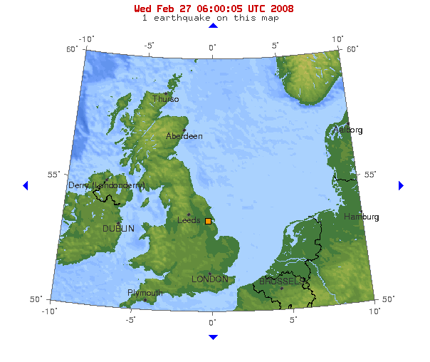
magnitude = 5.2 ML
depth=convert|18.6|km|mi|0
location=coord|53.40|N|0.33|W|display=inline,title
countries affected = UK
intensity = 6 EMS - Slightly Damaging
casualties = 1 reported; 0 fatalitiesThe 2008 Lincolnshire earthquake struck
Lincolnshire , in theUnited Kingdom , on27 February 2008 at 00:56:47.8s GMT. According to theBritish Geological Survey , the quake registered a reading of 5.2 on the Richter scale with theepicentre 2.5 miles (4 km) north ofMarket Rasen and 15 miles (24 km) south-west ofGrimsby . [http://www.earthquakes.bgs.ac.uk/earthquakes/reports/market_rasen_27022008/market_rasen_27022008_intro.htm BGS Earthquake report] ] The duration of the earthquake was confirmed as roughly 10 seconds. citeweb | first=Fran | last=Yeoman | title=Earthquake hits Britain, 5.3 magnitude | publisher="The Times " | date=2008-02-27 | url=http://www.timesonline.co.uk/tol/news/uk/article3442675.ece | accessdate=2008-02-27]The tremors were felt across a wide area of
England andWales , fromHampshire in the south, toNewcastle upon Tyne in the north,Wiltshire in the south west and as far west as Bangor,Northern Ireland , with the effects being strongest around the epicentre in Lincolnshire. [citeweb | first=Gavin | last=O'Connor | title=Quake tremors are felt in city | publisher="South Wales Echo " | date=2008-02-27 | url=http://icwales.icnetwork.co.uk/news/uk-news/2008/02/27/quake-tremors-are-felt-in-city-91466-20529964/ | accessdate=2008-02-27] Structural damage was recorded in some areas, including one case where achimney had collapsed and injured a resident.The tremor is the largest earthquake to affect the UK since the
1984 Lleyn Peninsula earthquake , which measured 5.4.cite web | url =http://www.lincolnshireecho.co.uk/displayNode.jsp?nodeId=156130&command=displayContent&sourceNode=242285&home=yes&more_nodeId1=156139&contentPK=19996286 | first = | last = | origyear = | origmonth = | publisher = Lincolnshire Echo| work = | title = Lincolnshire earthquake "one of biggest ever"| accessdate = 2008-02-27]Cause
The 2008 Lincolnshire
earthquake was caused by the sudden rupture and motion along a strike-slip fault, convert|18.6|km|mi|0 beneath Lincolnshire. Earthquake motion occurred over a time span of ~2 minutes but it was most intense and was felt at the surface for just 10 to 30 seconds; maximum vertical ground motion at the epicentre of the earthquake was only ~1 mm. Computer calculations carried out by the BGS infersinistral motion on a N-S ordextral motion on a E-W orientated strike-slip fault. The nine aftershocks observed, ~convert|5|km|mi|0 SSW of the main earthquake event, point to an approx. N-S orientated fault. From the 5.2 ML magnitude of the main earthquake, a motion of a fewcentimetre s along a ~convert|2.5|km|mi|0 long fault rupture is derived.Cite journal
volume = 84
issue = 4
pages = 974–1002
last = Wells
first = Donald L.
coauthors = Kevin J. Coppersmith
title = New empirical relationships among magnitude, rupture length, rupture width, rupture area, and surface displacement
journal = Bulletin of the Seismological Society of America
accessdate = 2008-02-29
date = 1994-08-01
url = http://www.bssaonline.org/cgi/content/abstract/84/4/974] The energy released was 3.98×10¹²joules (equal to the detonation of ~950tonnes of TNT).citeweb |title=Earthquake Power Calculator | publisher=" [www.convertalot.com] " | accessdate=2008-02-29 | url=http://convertalot.com/earthquake_power__calculator.html]Unlike typical earthquakes worldwide, the earthquakes of
Northern Europe areintraplate earthquake s, meaning they are not close totectonic plate boundaries.Cite journal
doi = 10.1016/j.quascirev.2004.06.015
volume = 24
issue = 3-4
pages = 241–304
last = Cloetingh
first = S.
coauthors = P.A. Ziegler, F. Beekman, P.A.M. Andriessen, L. Matenco, G. Bada, D. Garcia-Castellanos, N. Hardebol, P. Dezes, D. Sokoutis
title = Lithospheric memory, state of stress and rheology: neotectonic controls on Europe's intraplate continental topography
journal = Quaternary Science Reviews
accessdate = 2008-02-29
date = 2005-02
url = http://www.sciencedirect.com/science/article/B6VBC-4F14YPM-1/2/474738a20e894ebebdfbdd18016a3c75] Most intraplate earthquakes in Northern Europe (and theUK ) are thought to be driven by distant tectonic stresses - a combination of E-W North Atlantic Ridge and N-SAfrican Plate regional stress fields, and local mantle conditions.Cite journal
doi = 10.1144/0016-764903-014
volume = 161
issue = 1
pages = 19–29
last = Bott
first = Martin H.P.
authorlink = Martin Bott
coauthors = Jacqueline D.J. Bott
title = The Cenozoic uplift and earthquake belt of mainland Britain as a response to an underlying hot, low-density upper mantle
journal = Journal of the Geological Society
accessdate = 2008-02-28
date = 2004-01-01
url = http://jgs.lyellcollection.org/cgi/content/abstract/161/1/19] Cite journal
doi = 10.1016/S0277-3791(00)00074-3
volume = 19
issue = 14-15
pages = 1469–1493
last = Firth
first = Callum R.
coauthors = Iain S. Stewart
title = Postglacial tectonics of the Scottish glacio-isostatic uplift centre
journal = Quaternary Science Reviews
accessdate = 2008-02-28
date = 2000-10-01
url = http://www.sciencedirect.com/science?_ob=ArticleURL&_udi=B6VBC-4183HR0-9&_user=10&_rdoc=1&_fmt=&_orig=search&_sort=d&view=c&_acct=C000050221&_version=1&_urlVersion=0&_userid=10&md5=afa4c363cec8cd3e52afaf742c5c39f4] Indeed, the motion on the strike-slip fault responsible for 2008 Lincolnshire earthquake is compatible with a local NW-SE stress field; a product of the E-W and N-S regional stress fields.Only a minority of earthquakes in the UK are related to
post-glacial rebound e.g. the minor earthquakes (<3.5 ML) of western Scotland, whereglacier s ~1 km thick existed during the peak of the lastIce Age .Impact
The earthquake resulted in structural damage to many homes and businesses in the epicentral area. Buildings as large as apartment blocks were reported to have shaken for up to 30 seconds afterwards. Birds and pets became highly agitated.citeweb|first=Julian | last=Kossof | title=Earthquake hits UK | publisher="
The Daily Telegraph " | date=2008-02-27 | url=http://www.telegraph.co.uk/news/main.jhtml?xml=/news/2008/02/27/nquake227.xml | accessdate = 2008-02-27] There were no deaths, but a 19 year old man inWombwell ,Barnsley ,South Yorkshire suffered a broken pelvis when a piece of chimney fell through the roof onto his attic bed,citeweb | title=Earthquake hits much of England | publisher=BBC | url=http://news.bbc.co.uk/1/hi/england/7266136.stm | date=2008-02-27 | accessdate = 2008-02-27] cite web |title=UK rocked by strongest earthquake in over 20 years |publisher="TV3 New Zealand" |date=2008-02-27 |url=http://www.tv3.co.nz/News/Story/tabid/209/articleID/47542/cat/41/Default.aspx |accessdate = 2008-02-27] The earthquake was felt by people as far south asHampshire , where it was felt as a mild but noticeable vibration, and as far away asBangor, Northern Ireland where it woke people.citeweb|first=Julian | last=Kossof | title=Earthquake hits UK | publisher="The Daily Telegraph " | date=2008-02-27 | url=http://www.telegraph.co.uk/news/main.jhtml?xml=/news/2008/02/27/nquake227.xml | accessdate = 2008-02-27] Police in the Midlands received more than 5,000 telephone calls in an hour from members of the public regarding the earthquake. The earthquake caused power cuts in some areas. A church in March,Cambridgeshire reported that since the earthquake, water was coming up from the ground into the cellar at a rate of convert|10|impgal|l per hour. The water is being analysed to find out if it comes from a water main or a natural spring.citeweb | title=Mystery of 'holy' water's source | publisher=BBC News Online | date=2008-03-26 | url=http://news.bbc.co.uk/1/hi/england/cambridgeshire/7314447.stm | accessdate = 2008-03-26] The St Mary Magdalene church atWaltham on the Wolds inLeicestershire had its spire damaged and will be rebuilt at a cost of £100,000.Fact|date=August 2008Magnitude
The British Geological Survey gave the earthquake a reading of 5.2 on the Richter scale, while the United States Geological Survey reported it measured 4.8Mb.citeweb | title=Magnitude 4.8 - England, United Kingdom | publisher="United States Geological Survey" | date=2008-02-27 | url=http://earthquake.usgs.gov/eqcenter/eqinthenews/2008/us2008nyae/ | accessdate = 2008-02-27] The French Atomic Energy Commission estimated the magnitude was 5.4 on the Richter scale.citeweb|title=Alerte Sismique | publisher="Commissariat à L'Energie Atomique (CEA)" | date=2008-02-27 | url=http://www-dase.cea.fr/evenement/evenements.php?type=alerte&identifiant=20080227-005651 | accessdate = 2008-02-27fr]
Aftershocks
A total of nine aftershocks were recorded. The largest, measuring 2.8 on the Richter scale, occurred around five weeks after the initial event, on
April 5 at 13:57 GMT. citeweb | title= Market Rasen aftershocks | publisher="British Geological Survey" | date=2008-04-14 | url=http://www.earthquakes.bgs.ac.uk/earthquakes/reports/market_rasen_27022008/market_rasen_27022008_aftershocks.htm | accessdate = 2008-04-14]ignificance
It was the largest earthquake in the UK since the
1984 Lleyn Peninsula earthquake , which was magnitude 5.4. The BGS described the earthquake as an "extremely large earthquake in UK terms but not large in world terms". Approximately 200 earthquakes occur in the UK every year, approximately 175 of which are small enough not to be noticed by humans.ee also
*
List of earthquakes in the United Kingdom
*Geology of the United Kingdom
*British Geological Survey
*London-Brabant Island References
External links
* [http://www.earthquakes.bgs.ac.uk/earthquakes/reports/market_rasen_27022008/market_rasen_27022008_intro.htm Report] from the
British Geological Survey
* [http://www.thisisgrimsby.co.uk/displayNode.jsp?nodeId=151901&command=displayContent&sourceNode=151727&contentPK=19996927&folderPk=86530&pNodeId=151458 Report] from The Grimsby Telegraph
* [http://www.emsc-csem.org/index.php?page=current&sub=detail&id=79520 Earthquake information] by the "European-Mediterranean Seismological Centre"
* [http://earthquake.usgs.gov/eqcenter/eqinthenews/2008/us2008nyae/ Earthquake information] by theUnited States Geological Survey
* [http://news.bbc.co.uk/2/hi/uk_news/england/7266136.stm Report] fromBBC News
* [http://news.sky.com/skynews/article/0,,30100-1307071,00.html Report] fromSky News
* [http://maps.google.com/maps?f=q&hl=en&geocode=&q=53.321%C2%B0N,+0.314%C2%B0W&ie=UTF8&ll=53.311186,-0.10437&spn=2.189112,6.514893&z=8&iwloc=addr Location of epicentre] onGoogle Maps
* [http://www.doncasterfreepress.co.uk/free/Earthquake-hits-Doncaster--readers39.3818724.jp Report and video] from theDoncaster Free Press
Wikimedia Foundation. 2010.