- Marojala
-
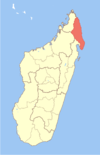
Marojala Location in Madagascar Coordinates: 14°29′S 50°2′E / 14.483°S 50.033°E Country  Madagascar
Region Sava District Sambava Population (2001)[1] – Total 13,000 Time zone EAT (UTC3) Marojala is a town and commune (Malagasy: kaominina) in northern Madagascar. It belongs to the district of Sambava, which is a part of Sava Region. At the time of the 2001 communce census, the population was estimated to be approximately 13,000.[1]
Only primary schooling is available in town. The majority 99.99 % of the population the commune are farmers. The most important crop is vanilla, while other important products are coffee, cloves and rice. Services provide employment for 0.01 % of the population.[1]
References and notes
- ^ a b c "ILO census data". Cornell University. 2002. http://www.ilo.cornell.edu/ilo/data.html. Retrieved 2008-02-23.
Andapa 
Antalaha Ambalabe · Ambinanifaho · Ambohitralanana · Ampahana · Ampohibe · Antalaha · Antananambo · Antombana · Antsahanoro · Antsambalahy · Lanjarivo · Marofinaritra · Sarahandrano · VinanivaoSambava Ambatoafo · Amboangibe · Ambodiampana · Ambodivoara · Ambohimalaza · Ambohimitsinjo · Analamaho · Andrahanjo · Andratamarina · Anjangoveratra · Anjialava · Anjinjaomby · Antindra · Antsahambaharo · Antsahavaribe · Bemanevika · Bevonotra · Farahalana · Maroambiny · Marogaona · Marojala · Morafeno · Nosiarina · Sambava · Tanambao DaoudVohemar Ambalasatrana · Ambinanin'andravory · Amboriala · Ampanefena · Ampisikina · Ampondra · Andrafainkona · Andravory · Antsahavaribe · Antsirabe Nord · Belambo · Bobakindro · Daraina · Fanambana · Maromokotra · Milanoa · Nosibe · Tsarabaria · VohemarCoordinates: 14°29′S 50°2′E / 14.483°S 50.033°E

This Sava region of Madagascar location article is a stub. You can help Wikipedia by expanding it.

