- Akagera National Park
:"Akagera" redirects here. For the river, see
Kagera River ."Infobox_protected_area | name = Akagera National Park
iucn_category = II

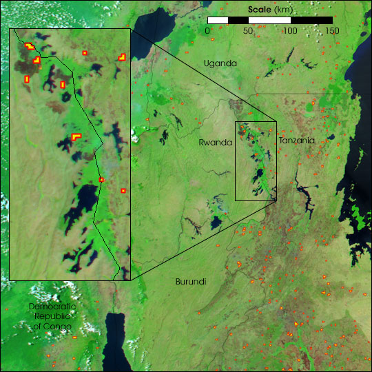
caption =Satellite photo from July 2004, showing fires (red) set by poachers next to a burnt section (gray) in the northern section of the densely forested (bright green) park (inset).
locator_x =
locator_y =
location =Rwanda
nearest_city =
lat_degrees =
lat_minutes =
lat_seconds =
lat_direction =
long_degrees =
long_minutes =
long_seconds =
long_direction =
area = 2,500km²
established = 1934
visitation_num =
visitation_year =
governing_body =The Akagera National Park (French: "Parc National de l'Akagera") covers 2,500km² in north eastern
Rwanda , against theTanzania n border. It was founded in 1934 to protect animals in threeecoregion s:savanna h,mountain andswamp . It includeslake s includingLake Shakani andLake Ihema .Much of the savannah area of the park was settled in the late 1990s by former
refugee s returning after the end of theRwandan Civil War , but the other regions remain relatively remote. Animals which fled during the upheavals are now returning. The park is named for theKagera River which flows through it.Literature
* Vande weghe, Jean Pierre: "Akagera: Land of water, grass and fire" / Jean Pierre Vande weghe. With collaboration of Thérèse Abandibakobwa, José Kalpers a.o. Photography by Philippe Dejace. Translated by Alicia L. Spruijt-Ray. - Brussels: World Wildlife Fund for Nature, 1990
External links
* [http://www.wcs.org/international/Africa/rwanda/akageranationalpark?preview=&psid=&ph=class%252525252525252525253DAWC-14877272 World Conservation Society]
* [http://www.stiopka.com/akagera/akagera.html October 2004 pictures]
Wikimedia Foundation. 2010.
