- Nyagatare District
-
Nyagatare District — District — Nyagatare District, Rwanda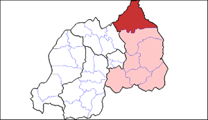
Country Rwanda Province Eastern Province Area - Total 1,741 km2 (672.2 sq mi) - Land 1,738 km2 (671 sq mi) - Water 3 km2 (1.2 sq mi) Population (2008) - Total 291,452 - Density 167.0/km2 (432.5/sq mi) Nyagatare is a district (akarere) in Eastern Province, Rwanda. Its capital is Nyagatare city, the former capital of the now defunct Umutara province. Its borders are Uganda in the North, Tanzania in the East, Gatsibo District (Eastern Province) in the South, and Gicumbi of Northern Province in the West.
Contents
Geography
Nyagatare is the largest district in Rwanda. Nyagatare lies in an area of grassy plains, and low hills, with excellent views in all directions, including the mountains of southern Uganda and, on a very clear day, the Virunga volcano range. The district has a higher temperature compared to the other parts of the country. It also receives lower precipitations. The land is not farmed as extensively as other areas of the country, and there is a large amount of cattle. The area has a higher average daytime temperature than the Rwandan average, and lower precipitation, which come sometimes lead to droughts. The District of Nyagatare is one of the seven districts making the Eastern Province. It is divided into 14 Sectors made of 106 cells and 630 Villages ”Imidugudu”. Spreading an area of 1.741 square kilometers, the district borders with Uganda at the north, Tanzania at its East, at the South by Gatsibo District and by Gicumbi District of the North Province on the Western border.
Sectors
Nyagatare district is divided into 14 sectors (imirenge): Gatunda, Kiyombe, Karama, Karangazi, Katabagemu, Matimba, Mimuli, Mukama, Musheli, Nyagatare, Rukomo, Rwempasha, Rwimiyaga and Tabagwe.
Topography
The District of Nyagatare is characterized, in general, by lowly inclined hills separated by dry allies for a long period of the year (June-October). The District is located in the granite low valley whose altitude is 1513,5m. This kind of topographical layout constitutes an important potentiality for modern and mechanized agriculture.
Demographics
The total population in Nyagatare is 291.452 inhabitants whose 51% are women. The overage density attains 167 inhabitants/km2 which is by far lower than the national density figure–321 inhabitants/km2. The sectors the most populated are Mimuli and Katabagemu which have 25.651 and 25.250 inhabitants, respectively. While the less populated are Rwempasha and Matimba having respectively 13.056 and 15.396 inhabitants.
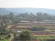 Nyarurema High School, Nyagatare District
Climate
The District of Nyagatare experiences small quantity of rains and hot temperatures. It is characterized by two main seasons: one long dry season that varies between 3 and 5 months with an annual overage temperature varying between 25,3 °C et 27,7 °C. The monthly distribution of the rains varies from one year to another. Annual rain falls are both very weak (827 mm/an) and very unpredictable to satisfy the needs in agriculture and livestock.
Hydrographic Description
The hydrographic network is very limited in the District of Nyagatare. The Akagera river flows East on the border with Tanzania. The river Kagitumba flows North on the border with Uganda. It ends in the Akagera river at the intersection of the 3 countries. The River Muvumba that cut across the District, is a result of the reunion of 2 rivers: the Ngoma and the Karungeli. Rice is grown in its large valley. The river is the main water reserve for the people and the cattle in the large dry land. There is no other consistent river that can be exploited by the population in Nyagatare. Few of the rivers found there such as Nyiragahaya, Kayihenda, Karuruma, Nayagasharara and Kaborogota are erratic and intermittent. The weak river network constitutes a serious handicap to responding to the needs of water for people and animals.
Fauna et Flora
The District of Nyagatare contains half of Akagera National Park where is found a vast number of Wild life including buffalo, Antelopes and more other ruminants. The District also accommodates a huge variety of birds such as birds of prey, guinea-fowl, partridges, heroes and so forth. The hares, Wild boars, monkeys and more other small beasts of the rodent family are rarely found in the wooden savanna and in the natural vegetation. There, in the River Umuvumba, you will find Hippopotamus. Because the park is not fenced, animals can come out to cause some damages in the neighboring human inhabited areas.
The Flora in Nyagatare is made, in general, by an afforested savanna vegetation and some forestry gallery. The latter constitutes a very precious reserve which should be rationally exploited.
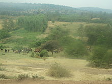 Nyagatare Countryside
Soils
The soil of this area is characterized by the tightness of the humifere layer of the soil brought about by the grassy savanna and by the vertisoils that are rich in nutrients mineral elements but lacking organic substances. These types of soils may be exploited with the help of modern agricultural techniques and form sorts of artificial pastures camps for livestock.
References
- Districts of Rwanda at statoids.com
- Inzego.doc — Province, District and Sector information from MINALOC, the Rwanda ministry of local government.
Districts of Rwanda by province Eastern 
Kigali Northern Southern Western Categories:


Wikimedia Foundation. 2010.