- Mount Erie (Washington)
-
Mount Erie 
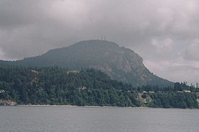
Mount Erie from Burrows BayElevation 1,273 ft (388 m) NAVD 88[1] Prominence 1,273 ft (388 m) [2] Location Location Skagit County, Washington, USA Coordinates 48°27′14″N 122°37′33″W / 48.453791292°N 122.625708886°WCoordinates: 48°27′14″N 122°37′33″W / 48.453791292°N 122.625708886°W[1] Climbing Easiest route Paved Road The Cascade Range from the Mt. Erie summit
Mount Erie is a mountain in Skagit County, Washington. The park land is owned and operated by the city of Anacortes and is located in the south of the Anacortes Community Forest Lands.
Mount Erie was named in 1841 by the Wilkes Expedition for the Battle of Lake Erie.[3]
The mountain itself was first explored in the 1960s by local climbers, including Dallas Kloke.[4] The mountain is known for its climbing as well as the view from the summit. Mount Erie is a city park operated by the City of Anacortes and the summit is accessible via a single-lane, paved road from the base. At 1,273 feet (388 meters) tall, Mount Erie is the highest point on Fidalgo Island.[1]
The mountain is composed mostly of feldspar and hornblende rich diorite.[5]
Geology
Located near the Fidalgo Complex in the San Juan Islands of Washington Mt. Erie has a unique and somewhat puzzling composition. Mt. Erie is thought to have been formed during the Jurassic period (155-170 Ma.) by invasive volcanic flows creating batholithic masses of diorite, which also helped to create the island arcs associated with the San Juan Islands. By the end of the late Jurassic period the area experienced uplift and erosion and was subjected to intense folding and faulting. At this point most of the deposited Paleozoic and Mesozoic sediments had been eroded away exposing the plutons of diorite, which is the primary igneous rock found on Mt Erie. The diorite pluton, at some point, experienced intrusion by gabbro dikes associated with the formation of oceanic seafloor. Indicating that the area may have experienced periods of submersion, as the Juan de Fuca plate subducted underneath the North American plate accreted the area. This whole process of constant uplift and erosion followed by accretion is thought to have created the unique ophialites associated with the San Juan Islands and primarily the Fidalgo Complex located near the mountain. During the Quaternary Period the area experienced many glacial periods and retreats and such evidence for the glacial erosion of Mt. Erie itself can be observed at the summit of the mountain as large striations in the diorite and gabbro. These periods of glacial erosion were separated by warming trends and continue to present day.
References
- ^ a b c "Park". NGS data sheet. U.S. National Geodetic Survey. http://www.ngs.noaa.gov/cgi-bin/ds_mark.prl?PidBox=TR1243.
- ^ "Mount Erie, Washington". Peakbagger.com. http://www.peakbagger.com/peak.aspx?pid=772.
- ^ Majors, Harry M. (1975). Exploring Washington. Van Winkle Publishing Co. p. 22. ISBN 9780918664006. http://books.google.com/books?id=CoWrPQAACAAJ.
- ^ "Climbing Area: Mount Erie". Washington Climbers Coalition. http://www.washingtonclimbers.org/Climbing/erie.htm. Retrieved 2010-03-05.
- ^ "Mount Eerie". SummitPost.org. http://www.summitpost.org/page/153999. Retrieved 2011-01-05.
External links
- "Mount Erie". Geographic Names Information System, U.S. Geological Survey. http://geonames.usgs.gov/pls/gnispublic/f?p=gnispq:3:::NO::P3_FID:1512193. Retrieved 2010-03-05.
- City of Anacortes Parks
- [1]
- [2]
Categories:- Anacortes, Washington
- Mountains of Washington (state)
- Parks in Washington (state)
- Landforms of Skagit County, Washington
- Parks in Skagit County, Washington
- Washington (state) geography stubs
Wikimedia Foundation. 2010.

