- Ortiporio
-
Ortiporio
Ortiporiu
Administration Country France Region Corsica Department Haute-Corse Arrondissement Bastia Canton Alto-di-Casaconi Mayor Sabrina Lunardi
(2008–2014)Statistics Elevation 313–1,236 m (1,027–4,055 ft)
(avg. 700 m/2,300 ft)Land area1 5 km2 (1.9 sq mi) Population2 126 (2008) - Density 25 /km2 (65 /sq mi) INSEE/Postal code 2B195/ 20290 1 French Land Register data, which excludes lakes, ponds, glaciers > 1 km² (0.386 sq mi or 247 acres) and river estuaries. 2 Population without double counting: residents of multiple communes (e.g., students and military personnel) only counted once. Coordinates: 42°27′21″N 9°20′33″E / 42.4558°N 9.3425°E
Ortiporio is a commune in the Haute-Corse department of France on the island of Corsica.
It shares the canton of Alto-di-Casaconi with Monte, Volpajola, Campile, Olmo, Prunelli-di-Casacconi, Campitello, Canavaggia, Lento, Bigorno, Scolca, Crocicchia and Penta-Acquatella.[1]
Contents
Geography
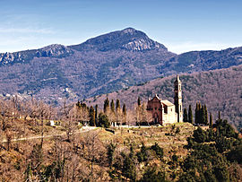
Ortiporio is 24 kilometres (15 mi) to the south of Campitello at the foot of Mont Campuli, which is 1,236 metres (4,055 ft).
Population
Historical population of Ortiporio 1962 1968 1975 1982 1990 1999 2008 141 167 119 100 104 113 126 See also
References
- ^ "France, le trésor des régions: Département: Haut-Corse". http://tresordesregions.mgm.fr/Mdir.php?p=cant.php®ion=94&cl=. Retrieved 2008-05-06. (French).
Categories:- Communes of Haute-Corse
- Haute-Corse geography stubs
Wikimedia Foundation. 2010.


