- Whitehead, County Antrim
Infobox Irish Place
name = Whitehead
gaeilge = An Cionn Bán
crest
motto =
map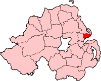
pin coords = left: 175px; top: 65px
north coord = 54.45 | west coord = 5.42
elevation =
province =Ulster
county =County Antrim
NI district = Carrickfergus Borough
UK constituency = East Antrim
EU constituency = Northern Ireland
stdcode = 028, +44 28
posttown =Carrickfergus
postcode = BT38
population = 3,702
census yr = 2001
web =
|Whitehead ( _ga. An Cionn Bán) is a seaside
village on the east coast ofCounty Antrim ,Northern Ireland , lying almost midway betweenCarrickfergus andLarne . Located at the base of Muldersleigh Hill, at the entrance toBelfast Lough , it lies in a small bay between the limestone cliffs of Whitehead and the black volcanic cliff of Blackhead, with the Blackhead Lighthouse on top, marking the entrance to the Lough. It had a population of 3,702 people in the 2001 Census.It is a Victorian Railway village with a well preserved Conservation area, including the Railway Station. It is home to the [http://www.rpsi-online.org/whitehead Railway Preservation Society of Ireland] , [http://www.cayc.freeserve.co.uk County Antrim Yacht Club] and the Council owned [http://www.bentragolf.co.uk Bentra Golf Course] , as well as being the starting point for the popular
Gobbins Path seaside walk past Sunshine House, around Blackhead Lighthouse and along theIrish Sea cliffs ofIslandmagee .Whitehead is about 20 miles from
Belfast . On the opposite coast ofBelfast Lough , theCopeland Islands , Bangor and part of theCounty Down coastline, are clearly visible.Whitehead received a silver at the
Britain in Bloom awards in 2005 and 2006, and a bronze in 2007. The towns [http://www.brighterwhitehead.co.uk Brighter Whitehead] group planted many of the flowers.Local Schools & Education
* Whitehead Primary School
* Lourdes Primary SchoolLocal Churches
* [http://www.whiteheadbaptist.org.uk/ Whitehead Baptist Church]
* Whitehead Presbyterian Church
* St Patrick's Church of Ireland
* Whitehead Methodist Church
* Our Lady of Lourdes (RC)Transport
*
Whitehead railway station was opened on1 May 1863 and the Whitehead Excursion Platform was opened on10 July 1907 . [cite web | title=Whitehead | work=Railscot - Irish Railways | url=http://www.railscot.co.uk/Ireland/Irish_railways.pdf | accessdate=2007-08-28|format=PDF] The through station is still part of theNorthern Ireland Railways network, whilst the terminus Whitehead Excursion Station is the headquarters of theRailway Preservation Society of Ireland .
* [http://www.translink.co.uk/ Translink Bus and Rail Website]History
The Troubles For more information see
The Troubles in Whitehead, County Antrim , which includes a list of incidents in Whitehead during the Troubles resulting in two or more fatalities.People
*
Neighbours actressJackie Woodburne was born in Whitehead in 1957.
*Sting (Gordon Sumner) lived with ex-wifeFrances Tomelty in Whitehead during the mid 1970s.
*Keith Gillespie (Northern Ireland footballer) went to Whitehead Primary School2001 Census
Whitehead is classified as an intermediate settlement by the [http://www.nisra.gov.uk/ NI Statistics and Research Agency (NISRA)] (ie with population between 2,250 and 4,500 people). On Census day (
29 April 2001 ) there were 3,702 people living in Whitehead. Of these:
*20.3% were aged under 16 years and 24.1% were aged 60 and over
*47.8% of the population were male and 52.2% were female
*15.4% were from aCatholic background and 76.8% were from a Protestant background
*2.7% of people aged 16-74 were unemployed.For more details see: [http://www.ninis.nisra.gov.uk/ NI Neighbourhood Information Service]
References
* [http://www.cayc.freeserve.co.uk County Antrim Yacht Club - Marfine Parade Whitehead]
* [http://www.bentragolf.co.uk Bentra Golf Course]
* [http://www.whiteheadgolfclub.com Whitehead Golf Club]
* [http://www.castlefm.co.uk Castle FM Carrick's Radio Station] {not to be confused with other local RSL's)
* [http://www.whitehead-ni.com Whitehead Community Association]
* [http://www.brighterwhitehead.co.uk Brighter Whitehead, established to ensure our town always looks its best]
* [http://www.rpsi-online.org Railway Preservation Society of Ireland]
* [http://www.culturenorthernireland.org/town_Home.aspx?co=16&to=349&ca=0&sca=0&navID=1 Culture Northern Ireland]See also
*
List of villages in Northern Ireland
*List of towns in Northern Ireland
Wikimedia Foundation. 2010.