- Mantshwabisi
-
Mantshwabisi Location in Botswana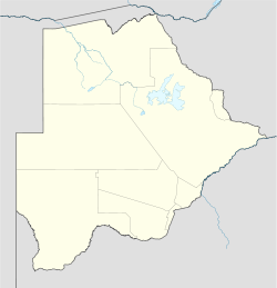
 Mantshwabisi
Coordinates: 24°10′53″S 25°16′28″E / 24.18139°S 25.27444°E Country  Botswana
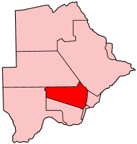
District Kweneng District Population (2001) - Total 464 Mantshwabisi is a village in Kweneng District of Botswana. It is located 45 km north-west of Molepolole, along the Molepolole–Letlhakeng road. The population of Mantshwabisi was 464 in 2001 census.[1]
References
- ^ "Distribution of population by sex by villages and their associated localities: 2001 population and housing census". Archived from the original on 2007-11-24. http://web.archive.org/web/20071124145459/http://www.cso.gov.bw/html/census/dist20_30_31.html. Retrieved 2008-02-09.
Urban villages 
Rural villages Boatlaname · Botlhapatlou · Ditshegwane · Ditshukudu · Dutlwe · Gakgatla · Hatsalatladi · Kaudwane · Kgope · Khudumelapye · Kotolaname · Kubung · Kumakwane · Kweneng · Lentsweletau · Lephephe · Losilakgokong · Maboane · Mahetlwe · Malwelwe · Mantshwabisi · Metsimotlhaba · Mmankgodi · Mmanoko · Mmopane · Mogonono · Monwane · Moshaweng · Motokwe · Ngware · Salajwe · Sesung · Shadishadi · Sojwe · Sorilatholo · Takatokwane · Tsetseng · TswaaneCoordinates: 24°10′53″S 25°16′28″E / 24.18139°S 25.27444°E
Categories:- Botswana geography stubs
- Kweneng District
- Villages in Botswana

Wikimedia Foundation. 2010.