- Andermatt
Infobox Swiss town
subject_name = Andermatt
municipality_name = Andermatt
municipality_type = municipality
image_photo = Andermatt.jpg
imagepath_coa = Andermatt-coat of arms.svg|pixel_coa=
languages = German
canton = Uri
iso-code-region = CH-UR
district = n.a.
lat_d=46|lat_m=37|lat_NS=N|long_d=8|long_m=35|long_EW=E
postal_code = 6490
municipality_code = 1202
area = 62.15
elevation = 1447|elevation_description=
population = 1312|populationof=2002
website = www.gemeinde-andermatt.ch
mayor = Hansueli Kumli|mayor_asof=|mayor_party=
mayor_title = |list_of_mayors =
places =
demonym =
neighboring_municipalities=Airolo (TI),Göschenen ,Gurtnellen ,Hospental ,Tujetsch (GR)
twintowns = |Andermatt is a municipality in the canton of Uri in
Switzerland .It has a population of 1,312 inhabitants has an area of 62.15 km². With
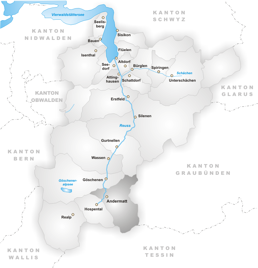
Realp andHospental , it is located in theUrseren valley, 22 km south of Altdorf.Geography
Andermatt is located in a high Alpine valley—the
Ursern Valley —in theAdula Alps .Transport
Andermatt serves as a crossroads between southern Switzerland and the North as well as between eastern Switzerland i.e.
Graubünden /Grisons and Western Switzerland, i.e.Valais , Berne and the Swiss Romande. The town is thus connected by four Alpine passes: theOberalp Pass to the East, theSt. Gotthard Pass (6,916 ft) to the South, theRealp Pass (5,046 ft) and theFurka Pass (7,992 ft) to the West, as well as theGöscheneralp Pass (5,850 ft) to the North. The SchöllenenGorge in the Reuss Valley between Andermatt andGöschenen is the location of the infamousDevil's Bridge .Roads
Rail
It is a station on the
Matterhorn-Gotthard-Bahn .Airports
History
Archaeological finds dating back to 4,000 BC indicate that the Ursern Valley was populated already in the
Neolithic period. During Roman times this Alpine valley was probably inhabited by some Helvetic Celtic tribes. However, the origins of Andermatt can only be traced back to Alemannic tribes, theWalser s, who established settlements in the area, where the current town of Andermatt is situated.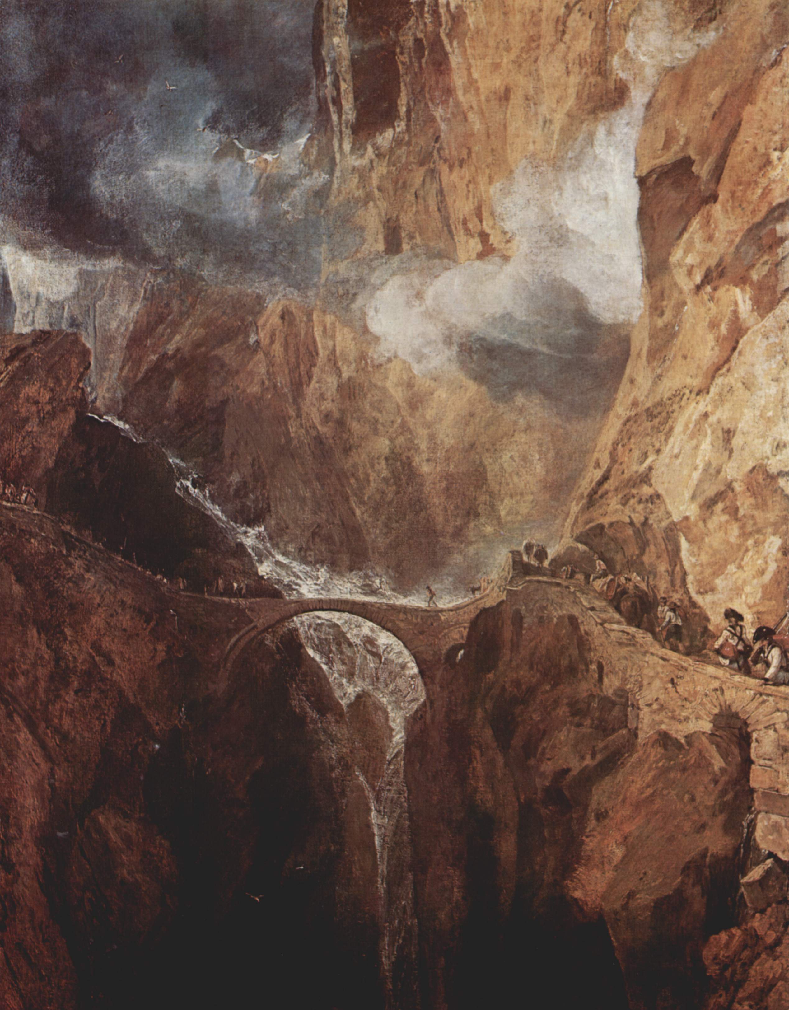
thumbnail|left|200px|The Devil's Bridge by J.M.W. TurnerA ceremony will also mark the momentousFlight of the Earls through the small town of Andermatt exactly four centuries ago this St Patrick's Day.The currently serving Irish Ambassador to Switzerland Mr. James Sharkey said weeks of celebrations will lead up to the inauguration of the memorial.
The last Gaelic Earls fled English rule on a small ship from Co
Donegal in1607 in a defining moment that would forever alter the course of Irish history.On their way towards
Spain - where they intended to gather an army to reclaimUlster - they passed through Switzerland.On their epic journey over the Alps, the chieftains lost a fortune of gold down a ravine by the infamous
Devil's Bridge , near Andermatt, on St Patrick's Day in1608 .It has never been recovered and is known as the Lost Treasure of the
St Gotthard Pass .The new memorial to the earls will be inaugurated outside the old Church in Andermatt which, coincidentally, is dedicated to the Irish
Saint Columbanus ."Andermatt is a small town in the Alps - about the size of
Buncrana orCarndonagh in Co Donegal - and they already have two monuments there," said Ambassador Sharkey."One memorial monument is to the
Russia ns who reached the Alps in1814 while the other is to the French who resisted them during theNapoleonic Wars .This recent addition is to become the third monument commemorating the passage of historically important European events, this time to mark the passage of Irish Earls, who reached the Alps some 200 years earlier.
Celebrations marking relations between Ireland and Switzerland will start on February 27th. with an exhibition about the
Flight of the Earls in the Swiss frontier city ofBasel .
The Nobel Peace Prize winnerJohn Hume is to unveil the memorial to Ireland's last Gaelic chieftains.
Theparish of Andermatt was, however, not mentioned until the year of 1203 AD, serving as a tenure to theBenedictine Disentis Abbey . In 1649 AD, with the emergence of an independentSwiss Confederation , the ecclesiastical rights of the Monastery Disentis were revoked in favour of civil legislation.Between 1818-1831 AD the nearby
St. Gotthard Pass was made accessible tostagecoaches . As the last resort before the pass, Andermatt flourished economically and became a popularspa town .The opening, in 1881 AD, of the St. Gotthard railway tunnel, however, reverted its fortunes as the tunnel runs immediately beneath the town, connecting the Central Swiss town
Göschenen withAirolo inTicino . Some Andermattians, who worked on the tunnel were killed during its construction. A strike by the tunnel workers, furthermore, was put down through the use of military force killing a further four workers.Since 1885 AD Andermatt has been converted into a garrison town of the [http://www.vbs.admin.ch/internet/vbs/en/home.html Swiss Federal Army] . Here the infrastructure for the High Command of the Swiss Federal Army in an event of war was built. Today it is location of a [http://www.heer.vbs.admin.ch/internet/heer/de/home/uber/ausbildung/kompzengebda.html Training Centre] of the Swiss army.
Plans to build a series of reservoirs in the
Ursern Valley were voted down by the locals. Several avalanches, in particular in the winter of 1951 AD and 1975 AD have caused havoc in some residential areas of Andermatt killing the inhabitants of the houses affected.Tourism
kiing, hiking, biking, and snowshoeing
External links
*HDS|691
Wikimedia Foundation. 2010.