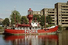
- Nore
-
For other uses, see Nore (disambiguation).
The Nore is a sandbank at the mouth of the Thames Estuary, England. It marks the point where the River Thames meets the North Sea, roughly halfway between Havengore Creek in Essex and Warden Point in Kent.
Until 1964 it marked the seaward limit of the Port of London Authority. As the sandbank was a major hazard for shipping coming in and out of London, in 1732 it received the world's first lightship. This became a major landmark, and was used as an assembly point for shipping. Today it is marked by Sea Reach No. 1 Buoy.
Contents
Lightship
The Nore is a hazard to shipping, so in 1732 the world's first lightship was moored over it[1] in an experiment by Robert Hamblin, who patented the idea. The experiment must have proved successful, because by 1819 England had nine lightships.[1] The Nore lightship was run by Trinity House, Britain's General Lighthouse Authority.
The early Nore lightships were small wooden vessels, often Dutch-built galliots.[1] By the end of the 19th century a larger ship with a revolving light had appeared, but after about 1915 the authorities ceased to use a lightship. Sea Reach No. 1 Buoy as of 2006 marks the anchorage-point of the former lightship, about mid-way between Shoeburyness in Essex and the Isle of Sheppey in Kent. This defines the limit of the Thames and the beginning of the North Sea.
From 1899 to 1955, the Royal Navy maintained a Commander-in-Chief, The Nore, a senior officer responsible for protecting the entrance to the port of London, and merchant traffic along the east coast of Britain.
Mutiny
Main article: Spithead and Nore mutiniesIn May/June 1797 the anchorage adjoining the Nore witnessed a mutiny in the British Royal Navy fleet then lying here, known as the Mutiny of the Nore.
Fort
A Maunsell army fort was erected here for anti-aircraft defence in 1943.[2] It was badly damaged in a collision in 1953 and dismantled in 1959–60.
References
- ^ a b c "Trinity House: Lightvessels" PortCities London
- ^ Shepherd, E. W. (1979). The story of Southend Pier and its associations. Letchworth: Egon Publishers Ltd. ISBN 0-905858-11-5.
 This article incorporates text from a publication now in the public domain: Chisholm, Hugh, ed (1911). Encyclopædia Britannica (11th ed.). Cambridge University Press.
Categories:- Sandbanks of England
- Geography of the River Thames
- Sandbanks of the North Sea
Wikimedia Foundation. 2010.

