- Burbach, North Rhine-Westphalia
-
Burbach 

 BurbachLocation of Burbach within Siegen-Wittgenstein district

Coordinates 50°44′40″N 8°05′10″E / 50.74444°N 8.08611°ECoordinates: 50°44′40″N 8°05′10″E / 50.74444°N 8.08611°E Administration Country Germany State North Rhine-Westphalia Admin. region Arnsberg District Siegen-Wittgenstein Municipal subdivisions 9 Mayor Christoph Ewers Basic statistics Area 79.66 km2 (30.76 sq mi) Elevation 365 m (1198 ft) Population 14,443 (31 December 2010)[1] - Density 181 /km2 (470 /sq mi) Other information Time zone CET/CEST (UTC+1/+2) Licence plate SI Postal code 57299 Area code 02736 Website www.burbach-siegerland.de Burbach is a municipality in the Siegen-Wittgenstein district, in North Rhine-Westphalia, Germany.
Contents
Geography
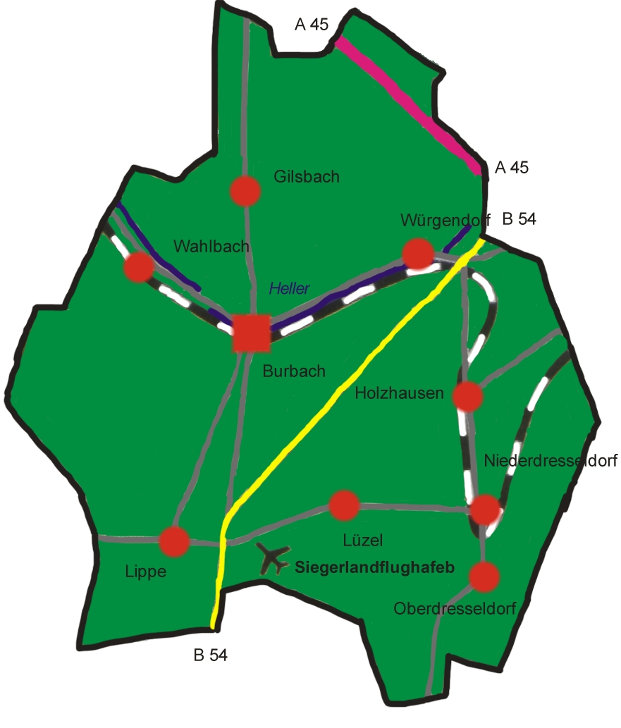
Burbach is located in Siegen-Wittgenstein district on the river Heller, about 15 km south of Siegen.
Constituent divisions
 Constituent communities
The community of Burbach consists of the following subdivisions: Burbach, Gilsbach, Holzhausen, Lippe, Lützeln, Niederdresselndorf, Oberdresselndorf, Wahlbach, Würgendorf.
Politics
Municipal council
The council's 32 seats are apportioned thus, in accordance with municipal elections held on 26 September 2004:
Coat of arms
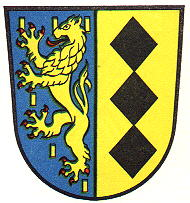
Burbach's civic coat of arms might heraldically be described thus: Party per pale, dexter in azure spangled with billets Or a two-tailed lion rampant Or armed and langued gules, sinister in Or three lozenges sable arranged vertically.
The lion stands for the princely House of Nassau-Siegen. The three lozenges (diamonds) come from the Lords of Seelbach, who held sway over the community in the Middle Ages.
The current civic coat of arms is based on the now abolished Amt's arms, and was granted in 1970. The local court for Burbach and Seelbach was already using the combination of a lion and diamonds by the 15th century.[1]
Economy and infrastructure
Transport
Running through the northeast of the municipal area is Autobahn A 45 (Sauerlandlinie). As well, the municipal area is connected in the east to Federal Highway (Bundesstraße) B 54, which runs from Siegen towards Limburg an der Lahn. Bus connections are provided by the Westphalia-South Transport Community (Verkehrsgemeinschaft Westfalen-Süd; VGWS) running to all neighbouring communities.
The community is directly connected to the Deutsche Bahn railway network by the Hellertalbahn railway running from Haiger to Betzdorf.
In the southern municipal area lies the Siegerland Airport.
Established businesses
Well known businesses in Burbach are:
- Expert Klein
- Foto-Drogerie-Kosmetik Bräuer
- Georgi Transporte
- Hering Bau (tracklaying)
- Heusel Kälte- und Klimatechnik
- SOPREMA-KLEWA Dachbaustoffe
- MHP Mannesmann Präzisrohr
- Orica, Werk Würgendorf (formerly Dynamit Nobel AG)
- razorcom it service
- Rittal
- Waldrich Siegen
- IPG Photonics
Notable people
Notable people associated with the town include:
- Cem Islamoglu, Turkish-German football player
- Wilhelm Killing, mathematician
- Hermann Schmidt, German politician
- Markus Waldrich, German football player
References
- ^ "Amtliche Bevölkerungszahlen" (in German). Landesbetrieb Information und Technik NRW. 31 December 2010. http://www.it.nrw.de/statistik/a/daten/amtlichebevoelkerungszahlen/index.html.
- This article incorporates information from the German Wikipedia.
External links
- Official site (German)
- Burbach in the Kulturatlas Westfalen (German)
- Catholic parish (German)
Bad Berleburg | Bad Laasphe | Burbach | Erndtebrück | Freudenberg | Hilchenbach | Kreuztal | Netphen | Neunkirchen | Siegen | Wilnsdorf Categories:
- Municipalities in North Rhine-Westphalia


Wikimedia Foundation. 2010.