Otter Trail

Otter Trail
Otter Trail
Otter Trail03.jpg
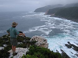
View from Skilderkrans across Bloubaai-Wes
Length 41 kilometres (25 mi)
Location Garden Route, South Africa
Trailheads Storms River Mouth
Nature's Valley
Use Hiking
Tidal pools at Ngubu Huts
Oakhurst Huts next to Lottering River at the ocean mouth
Sunset from Andre Huts at the Kliprivier mouth

The Otter Trail is a hiking trail along the Garden Route coast of South Africa and is named for the Cape Clawless Otter[1] which occurs in this region. This trail is widely regarded as one of the finest in the world and stretches from Storms River Mouth 34°01′15.5″S 23°52′47.5″E / 34.020972°S 23.879861°E / -34.020972; 23.879861 in the east to Nature's Valley 33°58′56″S 23°34′36″E / 33.98222°S 23.57667°E / -33.98222; 23.57667 in the west, is 26 km long as the crow flies and 41 km as the hiker walks. Walking the trail takes 5 days, and the 4 nights are spent in comfortable huts with superb views. The route is located entirely within the Tsitsikamma National Park, which protects an 80 km long strip of coastal mountains, forest and beaches.

The trail traverses an extremely scenic landscape, never straying far from the shoreline, but often climbing steeply and then descending to the beach or a river crossing. Vegetation along the way is either fynbos, dense gallery forest or open, rocky sections near the sea with an abundance of wildflowers.

Trail stages

  • Day 1 - 4.8 km (± 2 hours)
  • Day 2 - 7.9 km (± 4 hours)
  • Day 3 - 7.7 km (± 4 hours)
  • Day 4 - 13.8 km (± 6 hours)
  • Day 5 - 6.8 km (± 3 hours)
  • Total Distance 41 km

See also

References

  1. ^ Delien Burger, ed. "20. Tourism". South Africa Yearbook 2007/08 (15 ed.). South African Government Communication and Information System. pp. 548. ISBN 978-0-621-37568-8. http://www.gcis.gov.za/docs/publications/yearbook/2008/. 


Wikimedia Foundation. 2010.

Игры ⚽ Поможем написать реферат

Look at other dictionaries:

  • Otter (disambiguation) — Otters are aquatic or marine carnivorous mammals, members of the large and diverse family Mustelidae, which also includes weasels, polecats, badgers, and others. Otter may also refer to: Contents 1 Places 2 Vehicles 3 People 4 …   Wikipedia

  • Otter mound — Perserve Otter Mound Location Marco Island, Florida Coordinates …   Wikipedia

  • Otter River State Forest — Coordinates: 42°37′27.24″N 72°4′39.39″W / 42.6242333°N 72.0776083°W / 42.6242333; 72.0776083 …   Wikipedia

  • Otter Creek Wilderness — Coordinates: 39°01′58″N 79°39′13″W / 39.03278°N 79.65361°W / 39.03278; 79.65361 …   Wikipedia

  • Long-distance trail — Long distance trails (or long distance tracks, paths, footpaths or greenways) are the longer recreational right of way routes mainly through rural areas, used for non motorised recreational travelling (walking, backpacking, cycling or horse… …   Wikipedia

  • Maddron Bald Trail — Infobox Hiking trail Name=Maddron Bald Trail Photo=Maddron bald trail heath1.jpg Caption=Maddron Bald Location=Great Smoky Mountains National Park, Tennessee, United States Length=convert|7.2|mi|km Start/End Points=Baxter Road (just off US 321)… …   Wikipedia

  • OC&E Woods Line State Trail — OC E Trail through Klamath Falls at Wiard Park …   Wikipedia

  • Mormon Trail — Mormon Pioneer National Historic Trail Echo Canyon, Utah on Mormon Trail Location Iowa, Nebraska, Wyoming, Utah …   Wikipedia

  • Santa Fe National Historic Trail — Karte des Santa Fe Trails um 1845 Lage: Missouri, Kansas, Colorado …   Deutsch Wikipedia

  • Santa Fe Trail — Santa Fe National Historic Trail Lage: Mexiko, Vereinigte Staaten …   Deutsch Wikipedia

Share the article and excerpts

Direct link
Do a right-click on the link above
and select “Copy Link”