- Gmina Olszówka
-
Gmina Olszówka
Olszówka Commune— Gmina — 
Coat of arms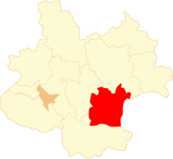
Coordinates (Olszówka): 52°11′N 18°50′E / 52.183°N 18.833°ECoordinates: 52°11′N 18°50′E / 52.183°N 18.833°E Country  Poland
Voivodeship Greater Poland County Koło Seat Olszówka Area – Total 81.54 km2 (31.5 sq mi) Population (2006) – Total 4,757 – Density 58.3/km2 (151.1/sq mi) Website http://www.olszowka.bazagmin.pl/ Gmina Olszówka is a rural gmina (administrative district) in Koło County, Greater Poland Voivodeship, in west-central Poland. Its seat is the village of Olszówka, which lies approximately 14 kilometres (9 mi) east of Koło and 133 km (83 mi) east of the regional capital Poznań.
The gmina covers an area of 81.54 square kilometres (31.5 sq mi), and as of 2006 its total population is 4,757.
Villages
Gmina Olszówka contains the villages and settlements of Adamin, Dębowiczki, Drzewce, Głębokie, Grabina, Krzewata, Łubianka, Młynik, Mniewo, Nowa Wioska, Olszówka, Ostrów, Ponętów Górny Drugi, Ponętów Górny Pierwszy, Przybyszew, Szczepanów, Tomaszew, Umień, Zawadka and Złota.
Neighbouring gminas
Gmina Olszówka is bordered by the gminas of Dąbie, Grabów, Grzegorzew and Kłodawa.
References
Other villages Adamin • Dębowiczki • Drzewce • Głębokie • Grabina • Krzewata • Łubianka • Młynik • Mniewo • Nowa Wioska • Ostrów • Ponętów Górny Drugi • Ponętów Górny Pierwszy • Przybyszew • Szczepanów • Tomaszew • Umień • Zawadka • ZłotaSeat Koło (urban gmina)
Urban-rural gminas Rural gminas Gmina Babiak • Gmina Chodów • Gmina Grzegorzew • Gmina Koło • Gmina Kościelec • Gmina Olszówka • Gmina Osiek MałyCategories:- Gminas in Greater Poland Voivodeship
- Koło County


Wikimedia Foundation. 2010.