Gmina Milówka

Gmina Milówka
Gmina Milówka
Milówka Commune
—  Gmina  —

Coat of arms
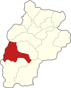
Coordinates (Milówka): 49°33′47″N 19°5′14″E / 49.56306°N 19.08722°E / 49.56306; 19.08722Coordinates: 49°33′47″N 19°5′14″E / 49.56306°N 19.08722°E / 49.56306; 19.08722
Country  Poland
Voivodeship Silesian
County Żywiec
Seat Milówka
Area
 – Total 98.33 km2 (38 sq mi)
Population (2006)
 – Total 9,965
 – Density 101.3/km2 (262.5/sq mi)
Website http://www.milowka.pl

Gmina Milówka is a rural gmina (administrative district) in Żywiec County, Silesian Voivodeship, in southern Poland. Its seat is the village of Milówka, which lies approximately 17 kilometres (11 mi) south-west of Żywiec and 77 km (48 mi) south of the regional capital Katowice.

The gmina covers an area of 98.33 square kilometres (38.0 sq mi), and as of 2006 its total population is 9,965.

Villages

Gmina Milówka contains the villages and settlements of Kamesznica, Laliki, Milówka, Nieledwia and Szare.

Neighbouring gminas

Gmina Milówka is bordered by the town of Wisła and by the gminas of Istebna, Radziechowy-Wieprz, Rajcza, Ujsoły and Węgierska Górka.

References


Wikimedia Foundation. 2010.

Игры ⚽ Поможем решить контрольную работу

Look at other dictionaries:

  • Milówka — Milówka …   Deutsch Wikipedia

  • Milówka — See also: Milówka, Lesser Poland Voivodeship Milówka   Village   Museum in an old wooden house …   Wikipedia

  • Milówka, Lesser Poland Voivodeship — For the village in Silesian Voivodeship, see Milówka. Milówka   Village   …   Wikipedia

  • Gmina Istebna — Infobox Settlement name = Gmina Istebna other name = Istebna Commune settlement type = Gmina total type = Total image shield = POL gmina Istebna COA.svg subdivision type = Country subdivision name = POL subdivision type1 = Voivodeship subdivision …   Wikipedia

  • Gmina Wojnicz — Infobox Settlement name = Gmina Wojnicz other name = Wojnicz Commune settlement type = Gmina total type = Total image shield = POL Wojnicz COA.gif subdivision type = Country subdivision name = POL subdivision type1 = Voivodeship subdivision name1 …   Wikipedia

  • Gmina Ujsoły — Infobox Settlement name = Gmina Ujsoły other name = Ujsoły Commune settlement type = Gmina total type = Total image shield = POL gmina Ujsoły COA.svg subdivision type = Country subdivision name = POL subdivision type1 = Voivodeship subdivision… …   Wikipedia

  • Gmina Radziechowy-Wieprz — Infobox Settlement name = Gmina Radziechowy Wieprz other name = Radziechowy Wieprz Commune settlement type = Gmina total type = Total image shield = subdivision type = Country subdivision name = POL subdivision type1 = Voivodeship subdivision… …   Wikipedia

  • Gmina Rajcza — Infobox Settlement name = Gmina Rajcza other name = Rajcza Commune settlement type = Gmina total type = Total image shield = subdivision type = Country subdivision name = POL subdivision type1 = Voivodeship subdivision name1 = Silesian… …   Wikipedia

  • Gmina Węgierska Górka — Infobox Settlement name = Gmina Węgierska Górka other name = Węgierska Górka Commune settlement type = Gmina total type = Total image shield = subdivision type = Country subdivision name = POL subdivision type1 = Voivodeship subdivision name1 =… …   Wikipedia

  • Olszyny, Gmina Wojnicz — For other places with the same name, see Olszyny. Olszyny   Village   …   Wikipedia

Share the article and excerpts

Direct link
Do a right-click on the link above
and select “Copy Link”