- Shire of Pyalong
Infobox Australian Place | type = lga
name = Shire of Pyalong
state = vic
region =
area = 577.57
est = 1863
seat = Pyalong
pop = 810 (1992) [cite book|title=Victorian Year Book|author=Australian Bureau of Statistics, Victoria Office|year=1994|page=52|id=ISSN 0067-1223]
logosize =
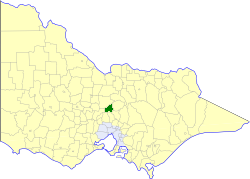
caption = Location in Victoria
county = Dalhousie
near-nw = McIvor
near-n = McIvor
near-ne = Seymour
near-w = Kyneton
near-e = Seymour
near-sw = Romsey
near-s = Kilmore
near-se = Broadford
_noautocat = yesThe Shire of Pyalong was a Local Government Area located about convert|85|km|mi|0 north of
Melbourne , the state capital of Victoria,Australia . The shire covered an area of convert|577.57|km2|sqmi|1, and existed from 1863 until 1994.History
Pyalong was first incorporated as a district on 2 September 1863, and became a shire on 5 May 1871.cite book|title=Victorian Municipal Directory|year=1992|publisher=Arnall & Jackson|location=Brunswick|pages=811-812 Accessed at
State Library of Victoria , La Trobe Reading Room.]On 18 November 1994, the Shire was abolished, and merged with the Shires of Broadford, Kilmore, Seymour and parts of McIvor into the
Shire of Mitchell . [cite book|url=http://www.ausstats.abs.gov.au/ausstats/free.nsf/0/76E601D6DB55E88ACA25722500049195/$File/12570_1994-95.pdf|title=Victorian local government amalgamations 1994-1995: Changes to the Australian Standard Geographical Classification|author=Australian Bureau of Statistics |date=1 August 1995|publisher=Commonwealth of Australia|page=9|isbn=0-642-23117-6|accessdate=2008-01-05]Wards
Pyalong was divided into three ridings , each of which elected three councillors:
* East Riding
* South Riding
* West RidingTowns and Localities
* Glenaroua
* Moranding
* Puckapunyal
* Pyalong
* Sugarloaf CreekPopulation
* Estimate in the 1958 Victorian Year Book.
References
Wikimedia Foundation. 2010.