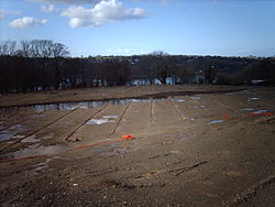
- Nantporth
-
Nantporth
Proposed site of Nantporth StadiumFormer names Normal Site Playing Fields Location Bangor, Gwynedd, Wales Coordinates 53°13′31.63″N 4°09′00.50″W / 53.2254528°N 4.150139°WCoordinates: 53°13′31.63″N 4°09′00.50″W / 53.2254528°N 4.150139°W Broke ground January 2008 Opened Unknown Owner Gwynedd Council Operator Bangor City Surface Grass Architect Morbaine Ltd Capacity 600 Tenants Bangor City from September 2009 Nantporth is a multi-sport venue on Holyhead Road in Bangor, Wales. It is currently in occasional use by Bangor University football and rugby clubs, as well as for practical lectures by the University's 'Normal Site' campus, which is home to the sports science and education faculties. The main pitch overlooks the Menai Strait, with stunning views in both directions along the coast. Work started on building a new football stadium on the site on August 1st 2011. It is thought Bangor City FC will play their last game at their current Farrar Road stadium on January 2nd 2011 before moving to Nantporth shortly afterwards. Photos of the ongoing development are shown on http://www.bangorcitizens.com
Bangor City Football Club History of Bangor City F.C. (1876–1968) · History of Bangor City F.C. (1968–1992) · History of Bangor City F.C. (1992–present) · Seasons · Europe Home stadium Rivalries Categories:- Bangor, Gwynedd
- Football venues in Wales
- Rugby union stadiums in Wales
- Stadiums under construction
- Welsh sports venue stubs
Wikimedia Foundation. 2010.

